USA – New England

I love the New England countryside; forested mountains, hilly pastures, red barns – postcard pictures. We decided to go there in the middle of September – which was too early for the famous autumn colours – so that we could escape the crowds which usually fill the rural roads during October, and to save some money of course as well.

After three days in Boston we headed north and that’s where, for me, the real New England begins.

My favourite New England state is Vermont, especially the Lake Champlain coast and islands. From Burlington we took US Hwy 2 north and then across the causeway, to visit tiny settlements located on the lake’s islands. From the south they are: South Hero, Grand Isle, North Hero, Birdland, Alburgh and some other tiny hamlets whose names I don’t even remember.

There you can visit country stores, art galleries or local cafés. Even when stopping for petrol you can chat with friendly locals over a cup of tea or coffee. We would have liked to stay a few days more in the area, but as it is with such road trips we had more things to see and not that much time. After crossing yet another causeway we entered New York State, specifically a town called Rouses Point. Most people associate this state with the urban craziness of New York City, but up in the north, next to the Canadian border, things couldn’t be more different; towns are small, country music rules and the sky is big.

We decided to eat at the tiny Gino’s Pizza – a place where the furniture harks back to the early ‘80s, people are friendly and the chef looked like he had just arrived from Naples, yet spoke with strong Yankee accent. When we asked for a big pizza, he said that because we are Europeans we should have a look how big the big pizza actually is. It was absolutely enormous so we took his advice and scaled down to the medium one (which was still bigger than any big pizza you can get anywhere else).

Absolutely full, we headed north again. After crossing the Canadian border without much hassle at the quiet and deserted border station we drove towards Montreal. I expected a lot from the famous city but unfortunately I was seriously disappointed. The biggest reason was due to the dreadful weather – it was raining like a hell for whole afternoon so we only had a quick walk and went back to our car completely soaked. At this point we decided to pass on Montreal sightseeing and drove west towards Toronto, hoping for a change of weather.

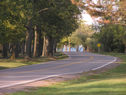
And what a difference a day can make. The following day was absolutely fantastic – sunny and warm but not too hot; perfect for a peaceful drive. We went off the main motorway and decided to explore the back roads. I especially recommend the Thousand Islands region, and the best way to visit it (apart from a boat of course) is to drive the 1,000 Island Parkway. It is an absolutely amazing road hugging water all the time with great views over the islands. Some of them are tiny with just one tree, on some there are houses, on others whole mansions and even a castle.

Another good way to see the varied topography of the St Lawrence waterway is a visit to the viewing tower located on the Hill Island, right next to the border crossing to the US. To get there you have to drive along a narrow and steep suspension bridge alongside massive 18-wheelers. It is a bit scary. From the top of the tower you can see how many islands and channels create the region. At the westernmost point of the region is the historic city of Kingston where you can stop for dinner or a bit of shopping.

Our next destination was Toronto. Driving from the east we used the famous (or infamous) Hwy 401. Some say it is the busiest road in the world; it has anything from12 to18 lanes and it is a weird experience to drive it. Fortunately we arrived to the Toronto area late in the evening and avoided the notorious 401 rush hours.

Toronto is actually a very nice city. If Montreal was a disappointment, Toronto was a big pleasant surprise (great weather definitely helped for a more positive experience). The day started with a visit to the CN tower. For a long time it was the tallest free-standing structure on earth but by the time of our visit it had already been overtaken by Burj Dubai. To be honest it doesn’t really matter it is not the tallest any more, it is still an amazing structure and offers stunning views from the viewing platform at 346m. Everyone brave enough should try to walk over the glass floor panels. Even I knew this was a very strong, perfectly safe floor, I still tried to step on the little metal frames joining the glass panels. I also realised that most people did the same thing.

After the tower we walked around the nice and compact Toronto downtown and visited the provincial parliament building which offers quite interesting, free, guided tours.

The best part of the whole Toronto experience was a visit to the beaches. Yes, Toronto has beaches – just a few miles east from downtown. All you have to do is to take a cool, old fashioned red tram and in 30 minutes you can enjoy the seaside-like environment. The beaches are surrounded by attractive old houses, and the main drag (Queen Street East) offers great food and shopping. There is even Kew Gardens for homesick Brits; they are a bit smaller than our Kew but it is still a nice spot. Our day in Toronto ended with a long walk along the beach at the sunset.

The following day we went towards Niagara. But before we reached the famous waterfalls we popped in to Niagara-on-the-Lake. It is a lovely small town set – as the name suggests – on the lakeshore and surrounded with wineries. It is a complete tourist trap, full of tour buses and American tourists looking for a British experience close to home. But it is still worth visiting and offers especially good shopping – locally made wine, Irish accessories, antiques, and organic food. And of course it is the perfect place for an afternoon tea.

The best way to approach Niagara Falls is to drive the Niagara Parkway – a scenic road connecting Lake Ontario with Lake Erie and follows the Niagara River for its entire 56km. Some say Niagara Falls is so commercialised, kitsch and tacky that going there it is a complete waste of time. I don’t think so. True, there are all the possible gift shops and tacky attractions you can only imagine, but the falls itself are still worth seeing. We just ignored the encroaching kitsch, and concentrated instead on the falls, which is not too difficult because they were truly amazing. I recommend going down to the base of the falls; after paying quite a hefty fee you can enter the tunnel leading to the base and it is worth every penny. As we approached, we could feel that everything was vibrating; the thousands of tonnes of falling water was making the ground shake. We stood on the platform with the falls right next to us – in fact, almost directly above us. We also went through smaller side tunnels which open right behind the curtain of water.

After the whole experience we were almost completely soaked; the plastic ponchos you get when you enter the tour don’t give much protection against the eternal mist forming behind the falls.

We continued south on the Niagara Parkway, which becomes very rural and quiet just a few miles from all the hustle and buzz of the falls. But it still offers beautiful scenery and is worth driving.

We entered back into the US at Buffalo which is completely insignificant and not worth a stop, although the countryside around it is very pleasant. We went off the main highway again to drive the back roads of upstate New York. We got a bit lost and almost ran out of fuel but saw plenty of nice towns and villages. After dinner in one of these small towns, we headed east towards the Big Apple, still a long way to go. We had to spend a night somewhere and it wasn’t easy to find motels off the main interstate highways in this rural region. We finally spotted one in the town of Warsaw. It was one of the dirtiest and dodgiest motels I have ever slept in, but it was late, we were tired and it was extremely cheap. Anyway, if you can, avoid staying in a motel in Warsaw.

The next day was spent driving the quiet highways on the New York – Pennsylvania border heading steadily towards New York City, which was our final destination. But this is the subject for a completely different story.

Author: Gregor Swiderek

Browse our collection of maps, guides and travel literature:
> USA travel guides
> USA road maps and atlases
> Travel literature inspired by the USA

USA – Disney World

So why do people travel? Many hope to experience different tastes, different cultures, many aspire to an inner journey in which some internal turmoil may be resolved or expect a new life path to be revealed.

For others, and it could be a majority of the 55 million UK residents who go abroad, the desires are more basic: they want to enjoy themselves for two weeks of the year, they want the family to be happy, they want to escape the humdrum of the norm’ and they want to feel sunshine on their backs.

We were on a package deal to Disney World, Florida, which included our flight, accommodation in a Disney Resort Hotel and access to all the theme parks. We were also given a Mickey Mouse credit card that you use to pay for food and gifts. This made it very easy to spend money, especially as everything you buy is delivered to your hotel, so you don’t have to cart round your three-foot high Winnie-the-Pooh. It does also have the advantage that you do not have to carry round wads of dollar bills.

For some this sort of holiday means that you are effectively living in a Disney bubble. This need not be the case, you can easily arrange car hire and explore Orlando and the rest of Florida, but, if you are there for just seven days there is an obvious desire to get your money’s worth, and to do that leaves little time for exploring. In the spare time I had, the desire to sit round the pool and actually relax and rest my weary feet was overwhelming.

The Movies Hotel was fine, the rooms were actually fairly spacious, even if the décor gave you a headache. The swimming pool was on the small side, but there were two lifeguards on duty between 8am and midnight. The catering arrangements were good: you could eat any time of the day, but otherwise the food was grim: if you wonder why you keep reading stories about American obesity, wonder no more. In the theme parks themselves the range of food was even worse – do you really fancy eating hot food including the obligatory fries when it’s in the mid-90s?

On our penultimate evening we ate at Fulton’s Crab House at Pleasure Island. This operates aboard a replica 19th century Mississippi river boat. We were up on the third floor (deck?) and had a superb view of the sun going down on Lake Buena Vista. The food was very good indeed, we actually caught sight of our first wine list, the service was not too cheesy, and the bill was expensive.

The organisation of the whole place is very, very impressive. The Disney buses take you everywhere, we had only one bad experience of standing in line. We stayed late at the Epcot Centre to watch the firework display and there must have been 5,000 people exiting to catch buses, but within 15/20 minutes the place was clear. Somehow I just can’t see this happening back home. The firework display was awesome, by the way, and they do it every night.

So what about the theme parks? We did Magic Kingdom, Animal Kingdom, Disney-MGM and the Epcot Centre. The best advice has to be to get up and out early, and organise yourselves to take advantage of the fastpass tickets. You will save huge amounts of time and derive considerable pleasure from this. All the theme parks have a multitude of toilets, all with baby changing facilities. Parents can hire big two-seater shopping trolleys/prams at all the parks, that make life a great deal easier for transporting the kids. There are water fountains in abundance so you do not have to carry bottled water round with you, though with the temperatures in the 90s it is always advisable. Even when we managed to lose a young child during the very popular firework display in the Magic Kingdom, the Disney organisation impressed.

It is very easy to be cynical about the whole experience, but can the 32 million people who visit Disney World be wrong? Actually I do not think they are. It is pure escapism (and pure commercialism), the family will love it (or most of it), you will feel the sun on your back (unless you’re very unlucky), and yes I did enjoy it.

We took with us the Brit’s Guide to Orlando, Florida and Walt Disney World by Simon Veness. This guide is considered the best for this area and is encyclopaedic in depth. It proved very useful and is highly recommended.

See maps and guides to Orlando

Author: Andrew Steed

Browse our collection of maps, guides and travel literature:
> USA travel guides
> USA road maps and atlases
> Travel literature inspired by the USA

England – The Thames Path

London - Thames Path
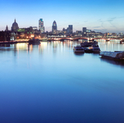
Our guide was very changeable, even capricious, taking us in one direction and then another. Our guide was the River Thames and led us from the docklands of east London to the leafy settlements of Buckinghamshire.

The Thames Path is 184 miles long and you can walk it from the source, in Gloucestershire, to the Thames Barrier; or do it the other way round as we did. Some people walk the whole path in a couple of weeks; others chop it into weekend jaunts. We decided to hike half of it and save the second half for a further holiday the following spring. The Cicerone Guide to The Thames Path by Leigh Hatts proved invaluable in planning our trip and follows the path upstream. If walking downstream I would recommend The National Trail Guide to The Thames Path by David Sharp. We also used the relevant OS 1:25,000 maps.

City highlights were numerous, and we were struck by one iconic landmark after another, all illuminated by glorious May sunshine. A familiar capital presented a different face to the workaday one, and by our first evening a holiday mood was definitely upon us, as we ate by twinkly riverside lights on Butlers Wharf, close to Tower Bridge.

As we journeyed westwards from Putney, the river took on a lusher, greener aspect and meandered more lazily. Bridges punctuated it less frequently and eventually gave way to islands. Surprisingly, there are over 100 islands in the Thames from sea to source. Eel Pie island in Twickenham is perhaps the most well known, being one of the longest and not surprisingly named after the dishes served up to boating parties.

However, when you get into ‘Three Men in a Boat’ territory, past Hampton Court Palace, you will see Tagg’s Island. Here Stan Laurel and Charlie Chaplin learned how to get laughs in Fred Karno’s hotel. You can find out more in River Thames – in the footsteps of the famous, by Paul Goldsack.

Rowers glided past providing a steady rhythm and we ended our adventure in Marlow, Buckinghamshire. A sighting of the Chiltern Hills whetted our appetites for a final hike to the source next year. The following day we reluctantly bade farewell to our guide and caught a train home.

Browse our collection of maps & guides:
> England travel guides
> England road maps and atlases
> Travel literature inspired by England
> Walking map and guides of London

Author: Stephen Edwards

USA – Coast to Coast on a Budget

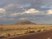
Driving across America is one of those things which you have to try at least once in your lifetime. Our trip started in Orlando. After three months’ work in Disney World, five of us were sick of Mickey Mouse and decided to go west.

After we had decided where to go, the trip budget became the biggest worry. To cut the cost we rented just one car (but big to fit the five of us, our luggage and all the shopping bought at Disney). To cut costs even more we decided not to stay in motels but to camp instead. We bought two of the cheapest tents, and five thin foam mattresses (even cheaper) in Wal-Mart.

After fitting all this stuff in the car (not an easy task) we finally started our journey on a beautiful September morning. The first day we just drove on and on and on all the way to Louisiana. It took us the most part of this first day to find the best configuration of people, luggage and food in the car. We also found what the best sitting position is if you spend 10 hours in a car. They were all very useful discoveries for the future. The first evening we also learned how to open our too small, too thin tents and how uncomfortable the foam mattresses were. On the other hand, we also discovered that it doesn’t really matter if you are tired.

Gregor Swiderek Driving West USAOn the next day, after a short drive, we reached New Orleans; The Big Easy. It wasn’t really on my list of priorities, but I was positively surprised. The city centre is very compact and the best way to explore it is simply by walking. The French Quarter still has a strong European feel: French street names, tables on the sidewalks opposite the cafés, horse carriages for tourists, and generally the atmosphere. But to me, the best thing was the architecture. New Orleans is full of one- or two-storey buildings with beautiful wrought-iron balconies. They look great, even if some of them are not really in the best condition. In fact the shabby ones look even better. And they look absolutely fantastic on a rainy day. We had to hide under one of these balconies, from the afternoon thunderstorm. It was one of those small and quiet side streets and we had an amazing time watching the rain.

Unfortunately we didn’t have the chance to enjoy the legendary nightlife of New Orleans as the west coast was still far away. We left the city early in the evening and took the Interstate 10. During the entire trip we never planned where to stop for the night, we just looked out for campsite signs. That evening we couldn’t find any. So, in an act of desperation we stopped by the sheriff’s office to ask for directions to the nearest campground. Folks over there were really friendly, though they didn’t know any campground around (by that time, looking at their faces, we knew that camping wasn’t very popular in Louisiana), so they recommended us simply to stop on the rest area alongside a highway. At the same time they also told us it is illegal to camp overnight on the rest areas in Louisiana. Hmm. Fortunately one of the deputies knew that it is legal in Texas. So we kept on driving west. Finally, around midnight or so, we reached the first rest area in the Lonely Star State, Texas.

Texas is big, very big. The first thing that struck us, in the morning, was the large amount of pickup trucks on the roads; it seemed like everyone, even mothers driving kids to schools, drove trucks. Then there are the roads; enormous, multi-lane rivers of concrete, especially around the big cities. But it is just part of the Texas experience. An even bigger part of the Texas experience is the landscape. When you move from east to west you notice a gradual change from the lush, green, flat landscape of marshes and forests, through hilly and green pastures to prairies and, finally, deserts. It took us more than a day to cross Texas, without even much stopping. We started in the early (kind of) morning from this first rest area in Texas and by night we were somewhere in the middle of the desert in western Texas. There we spent the night at a very remote and small campground. It was an amazing experience – as the evening was warm we didn’t use our “fantastic” tents – instead we decided to sleep under the open sky. I have never seen so many stars before, thanks to the remoteness of the campground (no light pollution) and dry desert air.

The next day we stopped in El Paso, a relatively big city isolated from the rest of Texas by hundreds of miles of deserts and mountains. We would never nornally have stopped there but we wanted to visit Mexico, and El Paso is a good place for a short visit. Its bigger counterpart is Ciudad Juarez on the Mexican side of the border. We left the car on the US side and walked across the border bridge. But I have to admit it was a bit of a depressing experience – the border was heavily guarded, especially because it was just two days after September 11, and beyond the border everyone tried to sell us absolutely anything, mostly rubbish, at ridiculous prices. So we came back after just two hours. Probably further from the border things get better but we couldn’t drive our rented car into Mexico. Anyway, it is better to avoid Ciudad Juarez as it is now a battlefield between the Mexican police and the drug cartels.

After El Paso we entered New Mexico, another state alongside our route, and the following day was another full of desert driving. We left New Mexico and entered Arizona. It is a truly remote corner of the US – a desert crossed by the highway. Only few small towns exist between Las Cruces (New Mexico state capital just 40 miles from El Paso) and Tucson in Arizona. Some might say it must be such a boring, long drive. No way!! The landscape around is absolutely jaw-dropping; it is a geology lesson without the need for books or maps. There is also this almost transcendental feel of going west towards the setting sun. A bit annoying from the driver’s perspective, but just a minor problem.

After Phoenix we turned north towards the Grand Canyon. Due to the high elevation, you drive through dense pine forest and are not aware of the Canyon until the very last moment when the road ends, and there it is. Massive, enormous, colourful – simply amazing. Nothing prepares you for its sheer size. You could see it many times on TV, you can know all its statistics, and you might even say you are completely not interested in nature, it simply doesn’t matter – once you stand on its edge and look down, you can’t help but be impressed. And you will remember this moment for many, many years.

After a cold night (due to the elevation) spent at a campground not far from the Canyon we decided to hike down. Our choice was the popular Bright Angel Trail. The whole thing is a bit weird – usually when you go to any mountain, first you climb and then you go down, but obviously with the Grand Canyon it is the opposite. You start the day with an easy hike down, in a nice morning breezy air, and the real fun starts when you have to claim back. By the time we decided to go back, sometime in the afternoon, the temperature had reached 35°C or even more. Especially at low elevations (the bottom of the Canyon is a good 1,500m below the rim), the temperature is much higher than closer to the rim. Even though we didn’t go all the way down, we still had good 1,000m to climb back up and it took us quite a few hours to reach the top. We were exhausted but satisfied; hiking is the best way to experience the Canyon. Views from the rim are amazing but you have to share them with millions of people. Going down, you leave 90 percent of the people behind you.

Gregor Swiderek - Las Vegas USATime. Time was our limitation. The same evening, after quick showers, we left Grand Canyon heading west of course. It took us four-and-a-half hours of desert driving to get to our next destination: Las Vegas. It was a great drive, the highway was almost empty and the sky was full of stars. Some good hours before Las Vegas we spotted some brightness on the horizon. It got bigger and shinier with every minute. At the beginning we didn’t know what it was – some small town, factory, or maybe a prison? Then we figured it out, they were the lights of Las Vegas. It is astonishing how far away you can see them across the dark and empty Arizona and Nevada deserts, and despite Vegas itself being hidden behind the mountains.

For the proper “Wow” effect, you have to arrive at Vegas by night. Believe me, I’ve seen it in the daylight and it doesn’t look so good, but come darkness, there is nothing like Vegas. It is one great show of neon, dancing fountains, fireworks, big cars and fast cars. Pure fun. We arrived at Sin City at about 11pm and stayed for just a few hours, enough to loose a few bucks in a casino.

We hunted for hours for a campground. We were so tired that we didn’t even realize how dodgy the campground we finally spotted at around 3am was – it had been a very, very long day. We hoped to wake up late to recover, but a strong desert sun made our tents hot as ovens. By 8am we were almost suffocating, and wide awake. We also realized that the campground was right next to the fence of the Air Force base, part of the famous area 51 (remember the X-Files?)

Another day, another desert. But this time it was the famous Death Valley, one of the hottest and driest places on earth. The record temperature was recorded in 1913, at a brain melting 134°F (56.6°C). By comparison we experienced quite a chilly day, just a miserable 47°C. But it is enough to make your eyes dry after you leave the car for more than a few minutes; you really feel like you’re drying out. But it is not all about meteorological records – Death Valley National Park is full of unique scenery – sand dunes, colourful rock formations and salt pans. And all this 85m below sea level. I highly recommend it!

After leaving Death Valley NP we drove west again towards Sierra Nevada, really an impressive mountain range, especially when you approach it from the east. Mountains rise to 4,000m above sea level in very short distance. It is, basically, a massive wall rising straight from flat desert. Very few mountain passes (usually closed in winter for heavy snowfall) cross them. We chose Tioga Pass (3,031m) which leads to the famous Yosemite. Before reaching the pass we passed lovely small towns like Lone Pine, Bishop, Independence or Big Pine. They are like oases surrounded by barren land. They are all full of friendly folks, and life there goes slowly, all of which makes these places the antithesis of stereotypical Californian towns. They are great places to stop, whether just for meal or for whole week.

We spent the night just before reaching the pass. At elevation around 2,000m it was another short and uncomfortable sleep – this time the reason was not the heat, like last night, but the very low temperature – our rubbish tents were completely inadequate for those conditions; I wore all of my clothes and it still didn’t help. So another day started early (everyone wanted to warm up a bit inside the car). Next time I go camping I’ll take a proper tent and sleeping bag.

We crossed Tioga Pass and entered Yosemite National Park. In my opinion it is the best national park in the US. The famous Yosemite Valley (the heart of the park) is more impressive than the Grand Canyon (at least for me). True, it is a busy place, and best to avoid it in mid summer, but the scenery is awesome. Walls of granite rocks, some of them more than a kilometre high, tower above the valley floor. Among them is the magnificent El Capitan, the ultimate place for rock climbers. Even if you don’t climb you feel how small we are compared with nature. You can spot small figures of climbers high in the wall; these people are completely crazy. Yosemite is also famous for its waterfalls which unfortunately almost disappear at the end of a dry summer (we were there in mid September), so the best time to see them is during the spring when snows are melting in higher elevations.

It was pity we couldn’t spend more time in the park (just a few short hours), but time was running out. We still had to reach the Pacific and then drive all the way back to Florida. So we left Yosemite in the afternoon and just before dusk we were approaching San Francisco. It was my first visit there, and the most memorable one. Merely crossing the Bay Bridge is a great experience. From this 14km double-deck suspension bridge, the view of downtown is truly amazing. Just before night we also crossed the famous Golden Gate Bridge. And that was it; finally my dream of seeing Golden Gate was fulfilled. Maybe it is not the highest or longest bridge, maybe views are better somewhere else, but for me this is the place I always wanted to see. It was the real climax of our trip.

Gregor Swiderek Driving West USAWe spent the following night in Muir Woods National Monument. We knew there was a free campground, but before we got there, we got lost in a network of small, narrow, curvy country roads. But on the plus side, this meant we got to explore Marin County. It is a great place, houses are hidden in dense forest, little towns are full of cool cafes, and all this in commuting distance from San Francisco. The only problem is the high prices of everything (it is, after all, one of the richest and most expensive counties in America).

After spending one day in San Francisco (itself a destination worth a separate story) we finally started going back east.

We had five days until our flight from Miami, and 5,022km to drive, and we actually did it quite easily. Driving 10-11 hours a day, we still had some spare time to say goodbye to friends in Orlando and to get refunds for our tents (Wal-Mart isn’t that bad after all!).

It was the best trip of my life so far, and I’m not exaggerating. It was tiring, it was crazy but it was great. So if you have two weeks to spare, if you are willing to sleep in the middle of nowhere, if you don’t mind sleeping in the cheapest tents in freezing conditions or in the desert heat, if you survive on the cheapest food from the cheapest supermarkets and if your bum can take 12 hours a day seating in the car, this is trip for you. But the most important thing, you need bunch of great friends which won’t drive you mad if you stay together 24 hours a day in a small space for two weeks. Fortunately we made a great team.

The essential thing to take is good road atlas. I recommend the atlas published by Rand McNally covering all 50 states. To read I recommend Moon guides as usual. Particularly the Moon Guide to New Orleans, Moon Guide to Texas, Moon Guide to New MexicoMoon Guide to Arizona and Moon Guide to Northern California. If you need more details just about the national parks, Moon also publishes separate guides to the Grand Canyon and Yosemite.

Author: Gregor Swiderek

Browse our collection of maps, guides and travel literature:
> USA travel guides
> USA road maps and atlases
> Travel literature inspired by the USA

Mongolia

A rather unexpected intermezzo occurred in our camp in the Gobi desert when my assistance was required for the slaughtering of a large goat. Goats, incidentally, live a happy life on the Mongolian steppes as they are freely herded around the countryside (there are no fences anywhere!) by happy shepherds and are at liberty to frolic and tumble around. But more importantly have been grass-fed all their happy lives with juicy, succulent pasture, and not administered any hormones or antibiotics habitual in the West. But I digress, a butchering was at hand and help was needed. Continue reading Mongolia

France – Slowly Up The Midi

“It’s just a floating caravan!”
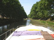
That was my wife’s first unhappy reaction to the sight of Beauregard, the French canal boat that we were about to spend the next seven days living on. In our family the holiday from hell has always been to endure the discomforts of camping or caravanning – why do people voluntarily make do with less than the comforts of home? So I could tell as we were shown around the compact layout of Beauregard by the local boat technician that my wife’s sunny vision of the next seven days was rapidly clouding over. When we got to the lesson on pumping out the miniature toilet, I confess that my enthusiasm began to waver too.

Our plan was a relaxing week’s cruise up the Canal du Midi in southwest France, from Argens-Minervois near Narbonne to Negra just short of Toulouse. The Canal is a marvel of engineering built in the late 17th century to link the Mediterranean to the Garonne River at Toulouse, and thereby via the Gironde to connect the Med to the Atlantic. The route passes through the historic city of Carcassonne, as well as the wine regions of Minervois and Cabardes, and is renowned for its peaceful and picturesque scenery.

Having completed the guided tour of our floating caravan, our technician, Eric, took us out into the canal for a crash course in boat handling. This included talking me through a 180-degree turn between the banks of the narrow canal, a trick I proudly accomplished but hoped never to have to repeat without Eric. And that was it – we and Beauregard were sent on our way.

In fact, keeping a boat on a mainly straight-line course through a canal is not too difficult – the children happily took turns at the wheel. Navigating our first lock was another matter. The principle of the thing is simple enough, particularly on the Midi where all 65 of the locks are manned by resident keepers who direct traffic and operate the gates and sluices. We managed to steer Beauregard neatly enough through the narrow opening into the belly of our first lock – the Midi locks are shapely ellipses built for strength and to accommodate several craft – but our first attempt to hurl our line fifteen feet up the lock wall to our daughter on top fell short. As the boat drifted helplessly out from the wall the failed tosses became even longer. Our confidence quickly turned to dismay and embarrassment as we floundered to secure ourselves. The more locks we notched up, however, the more slick our teamwork became. By the second, or maybe third, day, we even basked in our mastery of the process, looking askance at others who failed to execute a perfectly elegant passage.

Watercolour of Beauregard by Eilidh Schatz (aged 11) One of the first lessons we learned on the canal was that everything is best done slowly. The maximum cruising speed is 8km an hour – we only covered 120km in total in the whole week. The locks do not open until 9 in the morning and close at 7 in the evening, with an extra hour’s rest in the middle of the day to allow the keeper to have his lunch. You couldn’t get anywhere fast even if you wanted to. And the leisurely routine of life on the water is the whole point. A slow wakening and breakfast on board before the first lock opened, when we would be ready to navigate a few miles. Mid-morning we’d stop for re-fuelling; topping up our water supplies and cycling along the tow paths to the local villages in search of provisions. We lunched and read while the lockkeepers did the same, and then cruised through the afternoon. My favourite time of day was the last hour’s cruising in the early evening, when the rich sunlight softens the landscape and the milky waters of the canal are peacefully still.

From my detailed maps and guidebooks I was aware that we were passing tantalisingly close to the vineyards of the Minervois and I was keen to search out the local chateaux on our bicycles. By a stroke of good fortune, and much to the relief of my crew who were not so enthusiastic about a lengthy wine tasting expedition, I stumbled upon a wonderful Maison du Vins right beside the canal at the little village of Homps. After an enjoyable hour chatting to the helpful and expert staff about the local grapes and growers, I staggered out laden with enough samples for the week onboard and for the rack at home.

It is true to say that we spent less time than we usually do on this holiday “seeing the sights”. We were too busy going slowly up the Midi to have time for anything else. One of the exceptions was a lunch stop in “must-see” Carcassonne. We first glimpsed the famed turrets and towers of the walled city from the boat, the view sliding past like a medieval mural. Having moored near the train station we cycled through the lively streets of the lower town and ascended the steep hill to the Porte Narbonnaise, the impressive fortified entrance to the citadel. The hilltop cite is a Unesco World Heritage Site: it was here in 1209 that the Albigensian crusade besieged the Cathar heretics and when the city fell, the feared crusader leader, Simon de Montfort, made it the capital for his ruthless campaign.

Carcassonne, France We enjoyed a pleasant lunch in one of the myriad tourist restaurants that now line the narrow streets of the cite, and wandered around the cobbled lanes and battlements, browsing in the souvenir shops. My son was captivated by the countless medieval knights for sale, but I confess that – overwhelmed by the crush of summer tourists and knowing that much of what you see today is a fanciful 19th-century reconstruction – I found it difficult to conjure up the city’s dramatic history. We were pleased to return to the quiet of our boat and the unpopulated canal.

Our next stop of note was another landmark in Cathar history, the busy pleasure port of Castelnaudary. Its expansive Grand Bassin reservoir once served as a turning point for large grain barges in the Midi’s industrial past, where today pleasure craft of all shapes and sizes moor up and their owners flood the town in search of the classic local speciality, cassoulet. Legend has it that the dish made of white beans, garlic and bits of pork and sausage was invented here in the mid-14th century during one of the many crusader sieges when the locals were forced to make do with their last scraps of food. The putative original recipe is safeguarded to this day by a committee of local chefs known grandly as the Confraternity of the Grand Cassoulet. We promised our eight-year-old son a “stew” for dinner, which he heartily enjoyed, although we were careful not to identify all of its mysterious ingredients too explicitly!

As for further sightseeing, we felt little urgency to adjust our leisurely daily routine. Chugging slowly through the landscape gives you time to enjoy the scenery: the canal is typically lined by rows of regularly spaced plane trees that protect its solitude and provide welcome shade. In several memorable places they edge both sides of the channel, their tall straight columns and the arch of their branches creating a soaring nave over the water. The heads of sunflowers peak over the bank, and beyond, rows and rows of green vines stretch across the wide plains to the slopes of the black hills to the north. To the south, on a clear day, the hazy peaks of the Pyrenees are faintly visible.

Of course, one of the key selling points of camping or caravanning is that you can stop where you like. And so it is on the canal. Once the locks closed for the day, we moored our travelling home in a peaceful place, usually with only a local fisherman or two for company. We assembled dinner in our compact kitchen, played endless games of cards around the table, and sat out on the deck sipping the local rose and watching the stars gradually multiply overhead. When we reached our journey’s end and had to give Beauregard back, even my wife admitted that she would miss her.

The Navicarte guide to the Canal du Midi was indispensible for navigation on the canal. The strip maps show every bend in the river, and essential information on locks and cruising facilities and supplies. The Rough Guide to Languedoc and Rousillon was excellent for local cultural information. I also took the IGN Top 100 maps for the area for general reference a (Toulouse/Albi and Beziers/Perpignan).

A version of this article first appeared in the travel section of The Independent, 7 June 2008.

Browse our collection of maps, guides and travel literature:
> France travel guides
> France road maps and atlases
> Travel literature inspired by France

Author: Douglas Schatz

Douglas Schatz worked at Stanfords for more than 20 years, and was the company’s managing director until April 2009. He is now pursuing several exciting ideas in the world of books and digital publishing.

USA – Wild, Wild West

Kansas is one of the states I always wanted to visit. Maybe it’s not a place full of well-known world-class attractions but its name and image evokes classic pictures of America. The idea of going there was chasing me for the last few years, so planning my US trip for 2011 I decided to include it in my itinerary.

My tour of the southern plains started in Kansas City (KC) which, confusingly, is located in Missouri. Well, to make things even more complicated there are actually two Kansas Cities neighbouring each other, one in Missouri and one in Kansas. The one in Missouri is the proper city, with the classic American downtown, while the KC in Kansas is rather just a suburb. KC was traditionally seen as the gateway to the west. Cattle driven from Texas and other places by cowboys were slaughtered here or loaded into trains heading east, and migrants going west changed from trains to horse wagons.

Two main attractions of Kansas City are located next to each other, just south of downtown. The Union Station, a classic American train station representing the golden age of railways was one of the most important and busiest stations in the USA, and the Beaux-Arts building was the second-largest station in the nation when it opened in 1914. Nowadays it is nicely renovated and home to a family-friendly science museum (including 3D cinema and planetarium), Irish Museum, shops, restaurants and café. What is the most impressive is the size and architecture of the building itself. It indicates how busy a station had to be during its heyday. Ironically, it is now serving only four trains and around 400 passengers a day.

Right next to the station is the Liberty Memorial. Opened in 1926, it is a monument commemorating soldiers fallen during World War I. Built in Egyptian Revival style, it is an impressive structure indeed, topped by tall tower. Surrounded by a nice park and located on a hill overlooking downtown KC, the monument grounds are a great place for a stroll or a picnic.

From KC I drove west, entering the real Kansas. First stop, Lawrence, which is a small town, home of University of Kansas, and located about 60km from KC. It offers a relaxed atmosphere, some good food, coffee and shopping. Among the shops is Kansas Sampler, offering all things Kansas, like clothing (especially connected to various Kansas sport teams), magnets, cards, food etc; a great place to fill your suitcase with gifts. Another shop, which seriously puzzled me, was called “Brits”. Selling all sorts of British goods, it wouldn’t be out of place in touristy part of London. But in the middle of Kansas? Weird.

Next stop Topeka, capital of Kansas. Apart from the state capitol, it is not a particularly interesting place. Of course I did visit the Kansas State Capitol, but unfortunately it was undergoing reconstruction work, so tours were severely limited. It is a classic capitol building, two wings dominated by a massive dome, and it’s one of the tallest among all the capitols.

Wheat field, KansasWest of Topeka, settlements become smaller and distances between them get longer. This is Kansas how I have always imagined it. And I was absolutely loving it. After leaving the major freeway (I-70 to be precise) at Manhattan (yes there is a Manhattan in Kansas), I took Kansas Hwy 177 south. Called Flint Hills Scenic Byway, it is a really great drive. The road is winding between and on top of the gently rolling hills covered with natural pastures. Due to cherty soil, the land is better suited to ranching than farming. Because of this, the Flint Hills is still largely native prairie grassland, one of the last great preserves of tall-grass prairie in the country. Lack of trees allows for some amazing uninterrupted vistas which for me are an important part of the American experience. Tallgrass Prairie National Preserve near the Strong City shouldn’t be missed. Offering self-guided walking trails, which let you get close to this amazing environment, as well as historic 1881 ranch, it is run by the National park Service and a charity called Nature Conservancy. From there, a scenic stretch of Hwy 177 continues to the outskirts of Wichita, which being the largest city in Kansas was convenient place for an overnight stop.

Old Cowtown Museum in Wichita was probably the best unexpected attraction during my trip. I would have missed it if I didn’t stop overnight in Wichita as I found a leaflet about it in the motel I was staying in. Initially I thought it was simply a collection of old buildings but it is actually much more than that. It is a living history museum with actors in period clothes creating an authentic Old West atmosphere. It is absolutely brilliant. There is a saloon where you can buy the old-taste lemonade, blacksmith shop where you can watch a blacksmith at work, newspaper office with presentations of old printing methods, plus many other buildings like the sheriff’s office, dry goods store, train station, hotel, drugstore or bank, which you can enter and explore yourself. You can also join the horse wagon rides and watch occasional shoot-out on the main street. Most of the buildings are authentic and brought to the museum to save them from destruction at their original locations.  I was there for a few hours, which passed surprisingly fast while I had a lot of fun. After few minutes in the museum it is really possible to forget we have 21st century already. For anyone anywhere close to Wichita this place is a must-see destination.

Leaving Wichita I turned west again. Density of population went down quite dramatically and I could feel I was entering what was once called the Wild West. I chose US Hwy 160 which in this part of Kansas is called Gypsum Hills Scenic Byway. It was another great drive but landscape was quite different from that of the Flint Hills. Hills here were less round but rather more dramatic buttes with steep colourful slopes and flat tops. Ranching dominates here as well but vegetation was drier than that in the Flint Hills. The road was straight but going up and down, without end.

Moving further west and north, going towards the famous Dodge City, I entered the classic wheat-growing regions of Kansas. With roads stretching indefinitely towards the distant horizon and endless fields on the both sides of the highway you could feel like crossing some sort of wheat ocean. Only the telegraph poles and some distant wind farms provided vertical attractions in this mostly horizontal landscape. With the sun setting and country music playing, there is no better way of travelling. Forget luxury cruises or flying first class, forget nice restaurants or posh hotels. Cheap motels full of truck drivers and fast food joints, where a small size drink comes in a one gallon cup, is the way to go in these parts of the country.

Dodge City, with a population of 27,000 souls, feels like a real metropolis in this empty bit of the great plains. It was once the wildest of the frontier towns with characters like Wyatt Earp, James Earp, Ed Masterson and Doc Holliday serving as law enforcement. Nowadays Dodge is a sleepy western town where pick-up trucks dominate streetscape in the same way as yellow cabs do in the Manhattan. You can explore its colourful past in the Boot Hill Museum, whose name comes from Boot Hill Cemetery where cowboys were once buried with their boots on. It is another living history museum but much smaller than the one in Wichita. The big difference is also the fact that buildings here are reconstructions rather than original ones.

Crossing from Kansas to Colorado is surprisingly anti-climatic. Most people thinking of Colorado think of spectacular mountains. In reality the eastern third of the state is effectively an extension of Kansas with a flat landscape dominated by farming and ranching. But there are interesting things to see, too. One of them is Bent’s Old Fort National Historic Site near La Junta. It features a reconstructed 1840’s adobe fur trading post on the mountain branch of the Santa Fe Trail where traders, trappers, travellers, and Plains Indian tribes came together for trade. Kit Carson was employed there as a hunter, and the explorer John C Frémont used it as a staging area. Today, living historians recreate the sights, sounds, and smells of the past with guided tours and demonstrations. It is all really well done and the fort is nicely located on the banks of the Arkansas River.

Moving further south, there is the Texas panhandle, one vast expanse of bleak, flat land. Driving the Interstate 40, one can think there is nothing really to see but there are some hidden gems. And I don’t mean the largest cross in the western hemisphere (located in Groom and not really hidden, as you can see it for miles from the freeway), or the Cadillac Ranch in Amarillo. Cadillac Ranch is a quirky and interesting public art installation, and a great photo stop, but the real treasure of the panhandle is the Palo Duro State Park, sometimes called the Great Canyon of Texas. Well, it’s not really the Grand Canyon, but with depths of up to 300m, an average width of 10km and a length of almost 200km, it is an impressive geological feature. The park offers walking, biking and horse-riding trails among colourful rocky outcrops in the form of hoodoos, buttes, steep-walled mesas and other crazy shapes. As Georgia O’Keeffe once wrote, “It is a burning, seething cauldron, filled with dramatic light and colour.” The best time to visit is late afternoon when the temperature is lower and the light is good for photography. If you have only a bit of time, it is still worth stopping by and admiring this amazing landscape from the few viewpoints along the access road. If time allows, it is a great place for camping too.

For those interested in route 66 experiences, I recommend a stop in Shamrock, where a renovated art deco gas station, the “U-Drop-Inn Cafe”, serves as tourist information.

The next state on my journey was Oklahoma, which is also the 40th state I have visited (yeah, just 10 more to go). I crossed from Texas to Oklahoma in the town of Texola. It is located only 28 seconds from the 100th meridian which forms a border between the Texas panhandle and Oklahoma. During the early times its inhabitants lived in both of the states without ever moving, as the town was surveyed eight times. It was also aptly named Texokla and Texoma. To be honest I would never have stopped there if I wasn’t in search of historic Route 66. It is possible to drive some surviving bits of it, just west of town, but it was actually just a disappointing stretch of old two-lane concrete highway. Nothing special. I have to admit I never understood all the fuss about Route 66 but had to check if I was right in my scepticism. I was. There are more scenic roads in America, there are longer roads, and there are more impressive roads. Roads which actually still exist as opposed to Route 66. I blame clever marketing for all this madness.

Texola itself was surprisingly interesting. With only 36 inhabitants (according to 2010 census) it is practically a ghost town. Many buildings (including gas station which was once serving Route 66 – for those into these things) are falling apart or are completely overgrown; usually both. A great photo opportunity, but I seriously wonder where these 36 people live.

Oklahoma is greener than Texas and less flat. I recommend going off the main freeway and enjoy driving its peaceful state highways. For example Oklahoma Hwy 152 is a great alternative to busy interstate 40. Probably the most unexpected attraction in the state is Wichita Mountains. With a maximum of 750m elevation, they are not true mountains but the granite peaks are still rather unexpected and dominant in the gently rolling state. A big part of the region is protected by the Wichita Mountains Wildlife Refuge which, covered by the remnants of mixed grass prairie, is host to herds of bison and longhorn cattle as well as a colony of super-cute prairie dogs. Kids will love them. One place not to miss is definitely Mount Scott. From its rocky 751m peak you will get probably one of the best views in the Great Plains. Absolutely spectacular, especially just before the sunset. You can drive all the way to the top and the mountain road drive is fun in itself.

Bordering the wildlife refuge is Fort Sill. An active military installation, it is also a National Historic Landmark. You can visit it, but you will be asked for ID at the checkpoint. Fort Sill was built by General Sheridan in 1860s during the, so called, Indian Wars and it is one of the best preserved military outposts from that period. Many of the original stone buildings (most of which are still standing) were constructed by the famous 10th Cavalry, a group of black “buffalo soldiers”. Among the scouts stationed in the fort were Buffalo Bill Cody and Wild Bill Hickok. Geronimo was prisoner here and is buried at the fort; his grave is accessible to visitors. In short, Fort Sill has a fascinating history which is impossible to condense here.

I finished my Wild West experience in Oklahoma City where, as per tradition, I couldn’t skip the state capitol. It was a strange experience as it was Sunday, and apart from the guard at the gate, I was probably the only person in this vast building. It is actually the last capitol finished in the United States as its dome was only added in 2002. It is also the only capitol with its own active oil well.

Oklahoma City become unfortunately well known in 1995 when its federal building was bombed. Today, the well-designed Oklahoma City National Memorial commemorates 168 victims of that event. Located in the downtown, right in the place where the building was standing, it is a nice place to stroll or for a moment of reflection. On the neighbouring building, now hosting a museum, you can still see a damaged fire-escape staircase. To cheer things up during my visit, the whole city was in the heat of NBA playoffs because its team, Oklahoma City Thunder, was doing very well.

The Wild West is difficult to really define. Is it a place? Is it period of time? All I can say is that my trip across Kansas, Oklahoma and parts of Texas and Colorado had something which made me feel I’m a bit closer to understanding what the Wild West really is.
And I want to go back!

Unfortunately, the places I visited during this trip are not that well covered by guides. For Texas panhandle I would recommend the Moon Handbook to the whole state of Texas and for eastern Colorado there is the Moon Handbook Colorado. For navigating the back roads I used Kansas Recreational Atlas & Gazetteer and Oklahoma Recreational Atlas & Gazetteer as well as Rand McNally road maps for Colorado and Texas.

Author: Gregor Swiderek

Browse our collection of maps, guides and travel literature:
> USA travel guides
> USA road maps and atlases
> Travel literature inspired by the USA

USA – Pacific Coast Road Trip

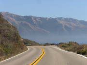
September 2004, after three months spent at a mountain camp in the wilderness of Sequoia National Forest, California, we were ready to hit the open road. Our camp was situated at 7,500ft above sea level and no less than two hours by car (which we didn’t have) to get to any civilisation. So we were eager for a change. The coast was our destination.

We rented a car at the Fresno International Airport. The word “international” was a bit of an exaggeration, as at the time of our visit they only had one flight a day to somewhere in the middle of Mexico. Californians say that Fresno and surroundings is the most boring and uninspiring part of California. They are right. We left the area as soon as we made ourselves comfortable in the car. Well, as comfortable as possible for four quite big guys in an economy class car.

After three hours we were approaching San Francisco. Nothing is better than driving to San Francisco from Oakland crossing Bay Bridge. It is a double-deck suspension bridge and towards San Francisco you drive on the top deck. The road leads directly to downtown San Francisco and you have the feeling that you are going to land on the roofs of the buildings. Truly impressive.

But we didn’t stop in the city. This trip was all about the coast. Just before dusk we crossed another famous bridge, Golden Gate, on our way north by US Highway 101. We were heading towards the wild coast of northern California. After an hour or so we left behind the suburban sprawl of the Bay Area. The road changed from freeway to dual carriageway first and to two-lane road after. All the cars disappeared and by 11pm we had the entire highway for ourselves.

We hadn’t booked any accommodation for that night, so we kept going and going and going. The road became curvy and narrow, crossing forests and mountains, including Redwood National Park, famous for its trees taller than sequoias. We crossed the park around 3am when it was wrapped in dense fog. It was one of those moments when you remember the dark episodes of X-Files and start worrying.

By 4am we reached Brookings, one of the first settlements in Oregon and decided that enough is enough. We spent a few hours half-sleeping in the parking lot of a local supermarket. This is the downside of a lack of planning when on a budget trip.

Because we couldn’t really sleep, the next day began early. At 6am the local McDonalds opened. It had a really strange profile of customers, mostly retired folks, many wearing WWII veteran pins or caps. We were clearly outsiders.

The morning fog disappeared quickly and we could finally appreciate the coastal views. And what views they were. The Oregon coast is amazing. Small bays, cliffs, lighthouses, little fishing communities, forests, mountains, sand dunes and, on a mid-week September day, an almost complete lack of tourists.

Car Stuck In The Sands Of The Oregon Coast, USAIn a moment of craziness we decided to explore the wild beaches and coastal dunes. In some parts they are open for cars, but we realised very fast (after 100 yards or so) that an economy-size saloon car with two-wheel drive is not the best for sand driving. Fortunately most locals drive pick-up trucks able to tow a tank, so one of them helped us get out of the sand. We decided to walk the remaining stretch until the beach. The beach was wide and wild, with tree trunks that could have arrived all the way from Siberia. It is the kind of coast I like. Not like the beaches of Florida or Mediterranean, crowded with tourists desperately getting tanned.

The same day, part of the coastal road (still US Hwy 101) was closed and we had to detour inland. Being a map fanatic, geographer and onboard navigator, I decided that I knew how to shorten this significant (100 miles or so) detour. It all started well but after a while we found ourselves stranded at a T-junction in the middle of Central Oregon Coast Range with signs pointing to a place called Deadwood in all three directions. Three way-signs to Deadwood, USA. Photo: Gregor SwiderekIt was too late to go back. We turned right (if I remember) and after some time on a very steep and narrow road, with a very poor surface and with no sign of civilisation (apart from signs mentioning the shooting of strangers), we managed to get to the main highway. By chance it happened to be the highway which we were looking for. I’m not such a bad navigator after all.

By the end of the day we crossed Columbia River via an impressive bridge in Astoria and entered Washington State. This night we decided to spend in a luxurious wooden cabin at one of the campgrounds.

Our next day started with a visit to Aberdeen. One from our group was a great Nirvana fan and Kurt Cobain was born and spent most of his life in this town. It is one of those small boring towns, one of the thousands in America. Apparently Kurt hated it. There is no sign or shop or anything mentioning the most famous of the Aberdeen residents. A lady at a place called: “The best hot-dogs on the world” told us that the idea of erecting a plate in memory of Cobain was in the air, but the city officials said no. After a quick photo next to the sign with the town name, we were on the move again.

We drove around the Olympic Peninsula, next to wild beaches and temperate rainforests of the Olympic National Park. Temperate rainforests are unique to few places around the world. Apart from the Pacific coast of Washington State and British Columbia, they also exist in New Zealand and southern Chile. They receive almost as much rain as tropical rainforests but the temperatures are much lower. It is real jungle, massive trees are covered with other plants growing on them – it is one fantastic green mess.Rainforests of the Olympic National Park. Photo: Gregor Swiderek

By night we were approaching Seattle. To save some time we took a ferry from Bremerton across Puget Sound to downtown Seattle. It was dark again by the time we reached our destination. Fortunately the view of Seattle’s skyscrapers from the ferry is equally stunning by either night or day.

Seattle is a great city, full of cafes (it’s where the first Starbucks opened), cheap eateries and nice people. One of the best places in town is Pike Place Market where you can buy almost anything. But it is more about atmosphere than about products. The fishmongers shouting to shoppers and throwing fish between themselves are an especially great sight.

Another great spot is Space Needle, a tower offering great views of the city, the Olympic Mountains across Puget Sound and (on clear days) magnificent Mount Rainer with eternal snows on top.

Seattle has quite a good public transport network. The main means is the bus tunnel which runs right underneath downtown. It is a bit like a metro but you see trolleybuses arriving at stations instead of trains. After leaving the tunnel they switch to diesel and travel to the many suburbs of Seattle including the University of Washington campus. I recommend this place for cheap good food, a nice atmosphere and good bookshops.

The next stop on our journey was Portland. It is three hours south of Seattle at the confluence of Columbia and Willamette Rivers. It is much smaller than Seattle but has the same progressive feel. Both cities have good public transport mainly because the Pacific North West residents are much more environmentally conscious than populations from other parts of the USA.

We had just one evening in Portland so we decided to visit some of the many local brew pubs. Apparently Portland is the city where brew pubs first became popular in the US. To find them you can go to the Northwest District, along 21st and 23rd Avenues. One of the beers we had was really strong and after few small bottles we went back to our hostel jaywalking.

Mount Shasta, on the way to San Francisco. Photo: Gregor SwiderekAfter Portland we drove straight back south to San Francisco. It was the starting point of the last part of our coastal trip, the Big Sur. Some say it is the best scenic road in the world. In San Francisco we slept in Green Tortoise Hostel located right on the Broadway between clubs, bars and restaurants. It was Saturday night, so we didn’t sleep that much. This hostel, similar to his brother where we stayed in Seattle, was a bit crappy, noisy and full of cool dudes. Generally a great option for someone looking for fun but not for some sleep.

The next morning we drove out of San Francisco. The beginning wasn’t too promising, one of those not so good and very busy highways (a lot of people go to the coast on Sunday). The first interesting spot was Monterey. It is an exclusive place full of expensive mansions, gardens, golf courses and iconic cypresses.

But the real fun started from there. California Highway 1 makes its winding way between Santa Lucia Range and the Pacific on the way towards Los Angeles. It is an amazing feat of engineering. This road crosses deep river valleys and runs on a very narrow strip of land right next to the high cliffs. Views are absolutely stunning. But you had better use view points (fortunately there are a lot of them) because the road is very curvy and driving requires your full attention. The weather was perfect during our trip but this part of coast is frequently covered by fog, making the driving really dangerous.

It is a very empty coast. It is in fact one of the emptiest coasts in the lower 48 states. On the way there are a few exclusive communities, art colonies or hidden private ranches. This is the most scenic and wildest between Carmen-by-the-Sea (an exclusive small town where Clint Eastwood was mayor for a while) and Morro Bay. No condos, no shopping malls, no crowded beach resorts or fast food joints, not even a single traffic light – 121 miles of true driver’s heaven.

After Morro Bay things go back to normal, little towns appear, and you can buy some food or gas. Closer to LA things get very hectic. California Hwy 1 joins US 101 and then becomes the LA freeway. That’s where the real madness began and our trip ended in Santa Monica.

Before you go I recommend you to read the Moon Guide to Coastal California and the Moon Guide to Coastal Oregon. If you need more information about the western states inland you need the Moon guides for Washington State and Oregon and a general guide for California.

For navigation we used the Road Atlas of USA published by Rand McNally, also available at Stanfords.

Author: Gregor Swiderek

Browse our collection of maps, guides and travel literature:
> USA travel guides
> USA road maps and atlases
> Travel literature inspired by the USA

A Himalaya Trek in the Shadow of Nanda Devi, India

Caroline Bowler, manager of Stanfords Bristol, and husband Tony D’Arpino trekked in the Indian Himalaya, finding it just as stunning as the more popular Nepal trekking routes, if not more so, and certainly freer of crowds…

We recently returned from a two- week Himalaya trek in northern India. Led by Mark Butterworth of Essential India, it was a journey into a land of light and unworldly vistas. The Garwhal Himalayas of the Uttaranchal district, unlike areas of Nepal, are relatively unknown. We met no other westerners during our time trekking on these ancient trade routes.

First you have to get there. From New Delhi we travelled by train to Haridwar, then by small bus across many of the prayags, the sacred confluences of rivers that drain into the Ganges, to the village of Mondoli, where the last road ends. We camped that first night in a mountain field shared with the ponies that would carry our supplies. As the sky cleared at sunset, the great peak of Trisul was suddenly visible.

The first day’s trek was long, sunny and hot, and we passed many villages with their terraced farms rising far above and below us. The rhododendron trees, larger than the largest English oaks, were in full scarlet blossom. Our trek was literally garlanded with the fallen flowers. We camped near the village of Wan, at one of explorer Eric Shipton’s old campsites, below a forest of Deodars – cedars the size of California redwoods. The Himalayan Griffon Vulture was a common sight and one day we were thrilled to see a Golden Eagle gliding in the thermals.

This was also a singing trek organised by Candy Verney, a community choir leader from Bradford-on-Avon and Sue Glanville www.allaboutthejourney.co.uk. We sang every night under the bright Himalayan stars, and were often joined by the local villagers who shared their songs with us. It was a wonderful example of communication, with song our only common language. Other highlights of the trek included the Aarti Ceremony on the River Ganges in Haridwar, in which floating candles in flower leaves are released with a prayer; and the stunning sight of Nanda Devi herself, the highest mountain in India, surrounded by the double circle of sanctuary peaks.

The best map for this area is still Garwhal Himalaya East published by The Swiss Foundation for Alpine Research (scale 1:150,000) . Two excellent background books on the area are Nanda Devi: A Journey To The Last Sanctuary by Hugh Thomson (Phoenix), and Garwhal and Kumaon: A Trekkers and Visitors Guide by K P Sharma (Cicerone).

Author: Caroline Bowler 

Girona and the Costa Brava

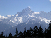
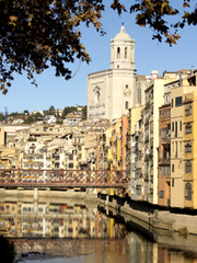
Girona has a quiet charm and a placid air about it. The best way to observe this is by walking the ancient city walls, stopping for contemplative rests at the intermittent observation towers. The views from here can be mixed – one glance throws up ugly cranes and scaffolding, the next red roofs and the soaring towers of Girona’s religious landmarks – but it is well worth the effort.

Further serenity can be found in the labyrinthine streets and steps of the old town, the Call (the former Jewish quarter, where there is a small museum documenting the history of Catalonia’s medieval Jewry before their 15th-century expulsion from Spain), and the squares, gardens and promenades that follow the River Onyar through the city. From the bridges that lead between old and new towns, you can observe eccentric buildings that line the banks of the river.

A useful guide for maps and inspiration is Triangle Postals’ compact guide to Girona, which also suggests trips and tours in north-eastern Catalonia. For a more detailed map, try the city plan by Telstar.

Easily accessible by coach, the national parks near Girona (try the volcanic Garrotxa National Park) and the rugged coastline leading up to the French border offer glimpses of Catalonia’s natural beauty. On the Costa Brava, you could always try visiting the resorts that are so popular, but you definitely shouldn’t miss the quiet fishing villages, coves and spectacular views to be found in some of the more remote places like Calella de Palafrugell, south-east of Girona.

If you have the energy, try walking some of the GR92 coastal path, which will take your breath away and may also leave you breathless. For excursions such as this, you could refer to the Catalan survey(see their excellent topographic atlas) and the Rough Guide to Spain. Walking Maps of Spain by Editorial Alpinaare also very useful due to the fact that they come with booklets to help plan walks and outdoor activities.

Browse our collection of travel guides and maps to Girona >

Browse our collection of travel guides and maps to Costa Brava >

Author: Tim Cleary