 September 2004, after three months spent at a mountain camp in the wilderness of Sequoia National Forest, California, we were ready to hit the open road. Our camp was situated at 7,500ft above sea level and no less than two hours by car (which we didn’t have) to get to any civilisation. So we were eager for a change. The coast was our destination.
We rented a car at the Fresno International Airport. The word “international” was a bit of an exaggeration, as at the time of our visit they only had one flight a day to somewhere in the middle of Mexico. Californians say that Fresno and surroundings is the most boring and uninspiring part of California. They are right. We left the area as soon as we made ourselves comfortable in the car. Well, as comfortable as possible for four quite big guys in an economy class car.
After three hours we were approaching San Francisco. Nothing is better than driving to San Francisco from Oakland crossing Bay Bridge. It is a double-deck suspension bridge and towards San Francisco you drive on the top deck. The road leads directly to downtown San Francisco and you have the feeling that you are going to land on the roofs of the buildings. Truly impressive.
But we didn’t stop in the city. This trip was all about the coast. Just before dusk we crossed another famous bridge, Golden Gate, on our way north by US Highway 101. We were heading towards the wild coast of northern California. After an hour or so we left behind the suburban sprawl of the Bay Area. The road changed from freeway to dual carriageway first and to two-lane road after. All the cars disappeared and by 11pm we had the entire highway for ourselves.
We hadn’t booked any accommodation for that night, so we kept going and going and going. The road became curvy and narrow, crossing forests and mountains, including Redwood National Park, famous for its trees taller than sequoias. We crossed the park around 3am when it was wrapped in dense fog. It was one of those moments when you remember the dark episodes of X-Files and start worrying.
By 4am we reached Brookings, one of the first settlements in Oregon and decided that enough is enough. We spent a few hours half-sleeping in the parking lot of a local supermarket. This is the downside of a lack of planning when on a budget trip.
Because we couldn’t really sleep, the next day began early. At 6am the local McDonalds opened. It had a really strange profile of customers, mostly retired folks, many wearing WWII veteran pins or caps. We were clearly outsiders.
The morning fog disappeared quickly and we could finally appreciate the coastal views. And what views they were. The Oregon coast is amazing. Small bays, cliffs, lighthouses, little fishing communities, forests, mountains, sand dunes and, on a mid-week September day, an almost complete lack of tourists.
 In a moment of craziness we decided to explore the wild beaches and coastal dunes. In some parts they are open for cars, but we realised very fast (after 100 yards or so) that an economy-size saloon car with two-wheel drive is not the best for sand driving. Fortunately most locals drive pick-up trucks able to tow a tank, so one of them helped us get out of the sand. We decided to walk the remaining stretch until the beach. The beach was wide and wild, with tree trunks that could have arrived all the way from Siberia. It is the kind of coast I like. Not like the beaches of Florida or Mediterranean, crowded with tourists desperately getting tanned.
The same day, part of the coastal road (still US Hwy 101) was closed and we had to detour inland. Being a map fanatic, geographer and onboard navigator, I decided that I knew how to shorten this significant (100 miles or so) detour. It all started well but after a while we found ourselves stranded at a T-junction in the middle of Central Oregon Coast Range with signs pointing to a place called Deadwood in all three directions.  It was too late to go back. We turned right (if I remember) and after some time on a very steep and narrow road, with a very poor surface and with no sign of civilisation (apart from signs mentioning the shooting of strangers), we managed to get to the main highway. By chance it happened to be the highway which we were looking for. I’m not such a bad navigator after all.
By the end of the day we crossed Columbia River via an impressive bridge in Astoria and entered Washington State. This night we decided to spend in a luxurious wooden cabin at one of the campgrounds.
Our next day started with a visit to Aberdeen. One from our group was a great Nirvana fan and Kurt Cobain was born and spent most of his life in this town. It is one of those small boring towns, one of the thousands in America. Apparently Kurt hated it. There is no sign or shop or anything mentioning the most famous of the Aberdeen residents. A lady at a place called: “The best hot-dogs on the world” told us that the idea of erecting a plate in memory of Cobain was in the air, but the city officials said no. After a quick photo next to the sign with the town name, we were on the move again.
We drove around the Olympic Peninsula, next to wild beaches and temperate rainforests of the Olympic National Park. Temperate rainforests are unique to few places around the world. Apart from the Pacific coast of Washington State and British Columbia, they also exist in New Zealand and southern Chile. They receive almost as much rain as tropical rainforests but the temperatures are much lower. It is real jungle, massive trees are covered with other plants growing on them – it is one fantastic green mess.
By night we were approaching Seattle. To save some time we took a ferry from Bremerton across Puget Sound to downtown Seattle. It was dark again by the time we reached our destination. Fortunately the view of Seattle’s skyscrapers from the ferry is equally stunning by either night or day.
Seattle is a great city, full of cafes (it’s where the first Starbucks opened), cheap eateries and nice people. One of the best places in town is Pike Place Market where you can buy almost anything. But it is more about atmosphere than about products. The fishmongers shouting to shoppers and throwing fish between themselves are an especially great sight.
Another great spot is Space Needle, a tower offering great views of the city, the Olympic Mountains across Puget Sound and (on clear days) magnificent Mount Rainer with eternal snows on top.
Seattle has quite a good public transport network. The main means is the bus tunnel which runs right underneath downtown. It is a bit like a metro but you see trolleybuses arriving at stations instead of trains. After leaving the tunnel they switch to diesel and travel to the many suburbs of Seattle including the University of Washington campus. I recommend this place for cheap good food, a nice atmosphere and good bookshops.
The next stop on our journey was Portland. It is three hours south of Seattle at the confluence of Columbia and Willamette Rivers. It is much smaller than Seattle but has the same progressive feel. Both cities have good public transport mainly because the Pacific North West residents are much more environmentally conscious than populations from other parts of the USA.
We had just one evening in Portland so we decided to visit some of the many local brew pubs. Apparently Portland is the city where brew pubs first became popular in the US. To find them you can go to the Northwest District, along 21st and 23rd Avenues. One of the beers we had was really strong and after few small bottles we went back to our hostel jaywalking.
 After Portland we drove straight back south to San Francisco. It was the starting point of the last part of our coastal trip, the Big Sur. Some say it is the best scenic road in the world. In San Francisco we slept in Green Tortoise Hostel located right on the Broadway between clubs, bars and restaurants. It was Saturday night, so we didn’t sleep that much. This hostel, similar to his brother where we stayed in Seattle, was a bit crappy, noisy and full of cool dudes. Generally a great option for someone looking for fun but not for some sleep.
The next morning we drove out of San Francisco. The beginning wasn’t too promising, one of those not so good and very busy highways (a lot of people go to the coast on Sunday). The first interesting spot was Monterey. It is an exclusive place full of expensive mansions, gardens, golf courses and iconic cypresses.
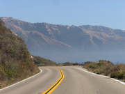
But the real fun started from there. California Highway 1 makes its winding way between Santa Lucia Range and the Pacific on the way towards Los Angeles. It is an amazing feat of engineering. This road crosses deep river valleys and runs on a very narrow strip of land right next to the high cliffs. Views are absolutely stunning. But you had better use view points (fortunately there are a lot of them) because the road is very curvy and driving requires your full attention. The weather was perfect during our trip but this part of coast is frequently covered by fog, making the driving really dangerous.
It is a very empty coast. It is in fact one of the emptiest coasts in the lower 48 states. On the way there are a few exclusive communities, art colonies or hidden private ranches. This is the most scenic and wildest between Carmen-by-the-Sea (an exclusive small town where Clint Eastwood was mayor for a while) and Morro Bay. No condos, no shopping malls, no crowded beach resorts or fast food joints, not even a single traffic light – 121 miles of true driver’s heaven.
After Morro Bay things go back to normal, little towns appear, and you can buy some food or gas. Closer to LA things get very hectic. California Hwy 1 joins US 101 and then becomes the LA freeway. That’s where the real madness began and our trip ended in Santa Monica.
Before you go I recommend you to read the Moon Guide to Coastal California and the Moon Guide to Coastal Oregon. If you need more information about the western states inland you need the Moon guides for Washington State and Oregon and a general guide for California.
For navigation we used the Road Atlas of USA published by Rand McNally, also available at Stanfords.
Author: Gregor Swiderek
- Browse our collection of maps, guides and travel literature:
- > USA travel guides
- > USA road maps and atlases
- > Travel literature inspired by the USA