 For most Americans, and visitors, North Dakota and South Dakota or Nebraska and Iowa are often seen as so-called ‘flyover’ states; places on the way from somewhere to elsewhere; boring flatness between the excitements of the east and west coasts. It is deeply unjust for these great places. Having said that, I have to admit I wasn’t initially planning to go there this summer. I was planning, for a long time, to visit spectacular western Canada. But, on one quiet afternoon, somewhere in February or March, I was walking by the USA section in Stanfords (which I take care of) when a map of North and South Dakota caught my attention. And that was it, after just a few minutes of studying it, I knew that my Canada plans were gone and the Great Plains were my next destination.
I started my trip in Minneapolis as it is a big transportation hub (with direct flights from London) on the edge of an otherwise sparsely populated region that I wanted to visit. I didn’t spend much time there. Firstly because I wanted to explore it at the end of my trip, and secondly because it was raining like hell. So, after a night in a random chain motel, I drove directly west to North Dakota. And boy, what a long drive it was – 420 miles (about six hours) – of the dead-straight interstate 94. Was I disappointed or bored? Absolutely not. After leaving the busy metropolitan region of Twin Cities it was just relaxing to cruise along the quiet and excellent-quality highway. Accompanied by lots of country music, I had a great day. That’s what I like about being in America.
Eventually I arrived to the quite small city of Bismarck, which is the capital of North Dakota. The biggest (and possibly the only) attraction there is the state capitol. Surprisingly anyone can enter it without any questions or security checks. I didn’t see a single CCTV camera inside or around it. What a difference from London or NYC, where even public toilets will soon require full, airport-style security. It is one of the only few state capitols without a dome. It is actually a quite spectacular art deco skyscraper, which, with its 19 floors, is also the tallest building in the state of North Dakota. Well, to be honest it is not that great an achievement if you consider that the population of the state is less than a million (650,000 to be precise) spread over a territory larger than England and Wales combined.
 The following day I left the major interstate behind and followed local state highways on my way to Theodore Roosevelt National Park. Travelling these smaller roads you can really appreciate the size and emptiness of North Dakota. There were long moments all the way until distant horizon when I couldn’t see a single vehicle in the front or rear view mirrors.
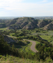
Theodore Roosevelt NP is one of the least visited in the whole national parks system (apart from Alaska), which means no crowds whatsoever. This park offers great opportunities to see wildlife (bison, prairie dogs, feral horses, elk, white-tailed deer and more) in a really great unspoiled landscape of amazing badlands formations. They are maybe not as spectacular as those in Badlands National Park (about which later), but lack of crowds makes it a great place to relax and soak up the atmosphere of the Wild West. The only thing you can hear, when you switch off the engine of your car, is the wind. The wind, which actually never stops blowing on the Great Plains, sometimes feels like it wants to blow your head off. I spent a night in the southern unit of the park at the campground located on the banks of the Little Missouri River. A nice, quiet spot, well protected from the wind, and located right off the scenic drive.
From the park I drove south towards the Black Hills region in South Dakota. It involved more hours on the empty highways cutting in straight lines across the vast open spaces. With more country music on the radio (by then I even started recognising some songs), it was a great time indeed.
Black Hills were named as such by Native Americans because they are covered by pine forests which appear black when seen from the distance. And in relatively flat South Dakota they are visible from far away. The word ‘hills’ is rather an understatement though, because this huge granite outcrop definitely has more of a mountainous feel than some proper mountain chains. With an area of over 4,800 square miles and elevation reaching 7,242 feet above the sea level (which is the highest point between the Rocky Mountains and the Alps) this varied region offers plenty of outdoor opportunities – camping, hiking, fishing, mountain biking, you name it.
But the biggest tourist attraction there is actually man-made: the world-famous Mount Rushmore. Most people are familiar with the image of four presidents’ heads sculpted into the mountain face. The whole place has a bit of a Disneyland-ish feel (including the huge gift shop and plenty of toilets) but you definitely shouldn’t skip it. It is, after all, a uniquely American icon. The most annoying thing about it is the fact that although there is free entrance you have to pay US$10 for an annual parking permit. Why on earth would anyone need annual parking there? Well, such is life.
Another interesting attraction in the Black Hills is Crazy Horse Memorial. Not finished yet, but already quite impressive, it is another mountain carving but much, much bigger than Mount Rushmore. In fact when finished it’s going to be the largest sculpture in the world. The whole project commemorates the great chief Crazy Horse and also includes a cultural and educational centre dedicated to Native American culture and history. It is also possible to join tours of the monument itself and there are laser shows after dark.
The interior of Black Hills is criss-crossed by some spectacular scenic roads. And I really mean spectacular. Let’s take the Peter Norbeck Scenic Byway. It is a loop, over 68 miles long, which follows four different local highways. So a good map is essential. Forget the stereotypical American road – wide, straight, designed for comfortable driving – this road is curvy and narrow, actually very curvy and very narrow. In some places it is just a ribbon of tarmac wide enough for one-and-a-half cars squeezed between the rock walls and a sheer drop on the other side. There are tunnels where you have to honk before entering, so you won’t have a head-on collision with some oversized pick-up truck, and pigtail bridges where you make full 360-degree circles. In general this scenic byway is more like a Spanish or Italian mountain road than an American highway. I really had fun driving it.
 During the few days I spent in the Black Hills, the weather wasn’t entirely cooperative. Rainy afternoons and evenings meant that I didn’t camp (even if I was tempted by some nicely located campgrounds) but instead used motels in Rapid City as my base. Still, I managed to hike a bit. One of the trails I do recommend is one leading to the Cathedral Spires. It starts from the small parking lot just off the SD highway 87 (part of the scenic byway) and leads to the top of some spectacular rock formations. From the top you can see even more rocky madness (spires, boulders, domes, etc.) It is a short but rather steep hike, especially the final section, where you climb some exposed rocks. If you prefer something easier, head just a few miles down the road to Sylvan Lake which offers a flat trail encircling it. Perfect for a half hour stroll, and you can still enjoy rocky scenery.
When the weather got really bad (it was raining all day long), I used my time to visit Wind Cave National Park. The major attraction there is one of the longest cave systems in the world. Based on the air movement, scientists estimate that over 200km of corridors explored so far represents only 5-10% of the whole cave system. Park rangers lead various tours throughout the underground maze. Although those tours cover only a fraction of the explored corridors they are long enough to let you understand the sheer size and beauty of the cave… and also make you tired end disoriented. It is also a really good way of escaping the rain, as you still stay close to nature but stay nice and dry.
From the Black Hills it was time to turn back east. On my way to Badlands National Park I decided to stop at the Ellsworth Air Force Base. It might sound like a strange destination but it is one of the few places in the world where you can visit a missile silo from the Cold War era. After visiting a small museum you will be driven through the active military base into disused Minuteman rocket silo. It is a surprisingly small and cramped place, and the whole experience is quite chilly. Not so many years ago thousands of similar rockets were waiting for launch command, ready to wipe out humankind from the face of the planet in a matter of minutes. Some are still there, waiting. Hopefully, nowadays people manning them are less trigger happy than in the hype of the cold war. Around the base museum you can also see some disused planes, among them the B1 bomber.
Fifty miles east of Ellsworth AFB, I finally got to probably the most spectacular destination during my entire trip – Badlands National Park. It is not a huge park by American standards but offers some great scenery. The main attractions there are multicoloured rock buttes eroded by wind and water out of soft rocks. And I mean really soft. Sometimes you can feel rocks eroding around you while you walk the trails. Unfortunately, the changing weather caused a shortening of my hiking experience. But even on a cloudy day you can still see how the rock formations change its amazing colours depending on the light. Apart from the geological wonders, Badlands NP also protects one of the largest remaining tracts of the mixed-grass prairie which once covered most of the Great Plains. It offers great contrast between deep green of the prairie (at least in spring) and red, brown, yellow or grey colours of the rocks. Scenic driving and strategically located viewpoints make exploration of the park easy – it’s easy to see it in a day. And if you are tired, hungry and thirsty you can always pop in to the world-famous Wall Drug Store, just outside the park in the small town of Wall. You can see billboards advertising the free ice water there for hundreds of miles in each direction. It started as a small local store but developed into a major tourist trap, including a few restaurants and a huge shopping emporium. Yes, it is kitsch, but offers some surprisingly entertaining shopping experiences.
One of the common misconceptions about the Great Plains is that it is a totally flat region. Nothing is more wrong. Of course there are some flat places but most of the region’s scenery is rolling hills. Nowhere is it more apparent than in Nebraska. If you look at the map of this state (in Stanfords for example), you can notice a big empty space in the middle of it, that’s the Sand Hills. The whole region is cut by just one road, Nebraska Hwy 2, also called Sand Hills Scenic Byway. It is not an extreme road like some in the Black Hills region, but more of a relaxing, gently curving one. The scenic part of the highway starts in the town of Alliance where you can visit Carhenge. It is one of those peculiar attractions which are common in the US but rare in Europe. In this case it is a reconstruction of Britain’s Stonehenge made of old cars. Weird and funny.
 From Alliance, the scenic byway continues for almost 300 miles in the east–southeast direction, crossing through the middle of the Sand Hills region. What makes the scenery of this part of the state so interesting is one of the world largest sand dunes systems. It is probably the largest dune area in the western hemisphere. Most people think of desert when they hear word dune but they are wrong. Dunes in Nebraska are actually covered by grass which makes them spectacularly green and also stabilise them to create a hilly, pastoral landscape. Highway 2 winds peacefully between these dunes, crossing small towns from time to time. One of them is Mullen in Hooker County. No, it is not me who stole the road signs with that county name on it, even if I have though about it. It was one of the most relaxing days during my trip. A lazy drive, not going anywhere in particular, just sort of floating in space. A day when I saw more cows than people. Such days, for me, are the highlights of a holiday in America.
I really recommend visiting the Great Plains to anyone who is looking for something more than just coastal America. In no other region can you appreciate how huge and sparsely populated this country really is. If I had to use one word to describe it, it would be “space”. The simple task of moving from one town to another may involve hours of driving through beautiful scenery. I absolutely love it. I love the big sky and the open horizon. And if you see it yourself you will probably fall in love too.
If you’re inspired to do such a trip, you’ll need DeLorme’s road atlases of North and South Dakota, Rand McNally’s maps of Nebraska, and North and South Dakota, while National Geographic do maps of all the US’s national parks. Moon publish a guide to Mount Rushmore and the Black Hills. Author: Gregor Swiderek
- Browse our collection of maps, guides and travel literature:
- > USA travel guides
- > USA road maps and atlases
- > Travel literature inspired by the USA
 Day trips in my family tend to take the form of several hours in a hot car on the way to the south coast, followed by 40 minutes wandering aimlessly over sand-dunes as storm clouds gather, and then another couple of hours in the car, in order to arrive back home in a foul temper. The temper is partly induced by having to spend what seems an inordinate amount time in a confined space with our nearest and dearest, and partly by the fact that whenever we choose to make these day trips, every single restaurant, café and hot food stall on the south coast has closed for the day, forcing us to eat our ‘emergency’ bacon sandwiches, which have spent the journey down congealing in a sorry brown paper bag.
 Yerevan – a little slice of California in the Caucasus?

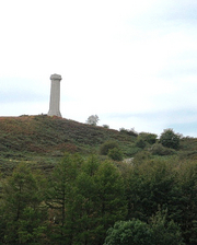
 Truth to tell, Hardy’s Monument looks more like a factory chimney than a memorial to a national hero. But the views over Dorset are sensational. Even more stunning is the prospect from the steep ridge above Waddon House, where we paused on the way back to Portesham. Downs and farmlands, the shingle bar of Chesil Beach, St Catherine’s Chapel on its knoll of strip lynchets, the Devil’s quoits pitch of Portland lying like the Gibraltar of Wessex on a bay of molten silver – if any view could entice an adventurous lad to sea, it would be this.
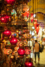 Istanbul, previously known as Byzantium or Constantinople and 2010’s European Capital of Culture, has long been considered an unmissable destination. The city offers everything from shopping and relaxation, to culture and historic landmarks.
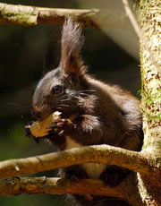 We all know the song – ‘If you in down to the woods today, you are in for a big surprise…’ – well I am yet to see any teddy bears having a picnic in the Black Forest, but you do have a good chance to see black squirrels!
 Before you head off on that luxury beach break to make you the envy of all your friends and give you a to-die-for tan (bleak pun intended), think carefully about what kind of things you really enjoy doing. If you force yourself to visit museums only because you think you should but actually prefer to shop, don’t be afraid to incorporate your real interests into your gap year.
 The kind of travelling you’ve already done should help you decide what you want to do now. You have two options: stick with what you know or try something new. I highly recommend the latter.
 Your gap year experience will partly depend on whom you share it with, so choose your travel companion(s) carefully.