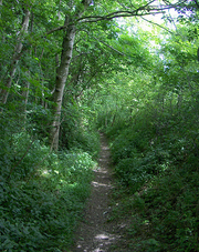
 Squirrels had been harvesting the green hazelnuts along Woodlands Lane; the split shells went crunching under our boots as we set out from Berwick St John on a cloudy morning. Beyond the gabled old house of Woodlands there was a bit of a pull up the breast of the hill, and then the exhilaration of a good old step-out along one of the ancient ridgeways that ride the nape of these south Wiltshire downs. Jane, a South Downs girl born and bred, strode out with a big smile on her face, delighting in the poppies along the cornfield headlands, the nodding harebells and powder-blue buttons of scabious in the trackway verges, and the sense of being high up among the swooping hills of proper chalk-and-flint country.
Steep hill slopes whose sheep-nibbled turf had never been disturbed by any plough plunged away to flat and sinuous valley bottoms, where the pale coffee colour of the newly harrowed earth lay streaked with darker chocolate, sign of watercourses still active under the soil. It was like walking on a relief map, a fabulous one. Full of exultation, we came down through Norrington Farm to reach Alvediston’s little Church of St Mary, where a group of recondite ramblers on a church crawl were discoursing in the churchyard.
 Blink and you’ll miss Alvediston. The thatched Crown Inn stood locked up tight, in a state of suspended animation between owners. Walking on, we found sparrowhawks clattering from the ash trees in Elcombe Hollow, fat sheep cropping the vale under Pincombe Down, and wonderful views along the sweep of the north-facing hills.
The Ox Drove is another ancient trackway of the Wiltshire Downs, broad and tree-lined between wide grazing verges, a drove road and pedlar’s highway since time out of mind. We followed it along the crest of the downs as cloud thickened in the north, looking out to the mounded ramparts of Winkelbury hillfort. The golden coffin buried at the summit, the lucky thorn tree that grows there, the devil who grants wishes to those who march round the hill while cursing and swearing… All yarns the drovers swapped and the pedlars spun to drive away the demons of the old hard roads across the downs.
Route map

~Due to licensing restrictions in place on Ordnance Survey mapping the mapping extract must be removed prior to printing, or all printing must be limited to 10 paper copies or less and used for personal use only.~
Route profile

Use this GPX file: [FILE:140] for importing the route into digital mapping products, such as Memory Map and Anquet or drop it straight onto your GPS unit. Check the instructions for your particular model to see how this is done.
Start & finish
Talbot Inn, Berwick St John, Wiltshire SP7 0HA (OS ref ST 947223).
Getting there
Berwick St John is signed off A30, 3½ miles east of Shaftesbury.
Walk
8 miles, moderate grade, OS Explorer 118Leaving Talbot Inn, round right bend; up Church Street. Round left bend by Old Rectory; in 20 yd, right (946224) along Woodlands Lane. Just past Woodlands House (951232), track splits three ways. Ignore yellow arrow; take middle way, diagonally left uphill for 600yds. Through gate in fence (948237; blue arrow/BA); aim half left across down to gate in far left corner (BA). On through next wooden gate; follow path to turn right along stony trackway (948245). In 1 mile, right (961248) down green path to Norrington Farm. Ahead through farmyard; past last barn, left (967238) over stiles through four fields to road (976238 – St Mary’s Church opposite). Right to T-junction in Alvediston (976234 – Crown Inn opposite). Right; in 50yds, left (‘Elcombe Farm’). Follow road, then track up Elcombe Hollow for 1¼ miles to Bigley Barn (977216). Right along Ox Drove trackway for 1½ miles. 250yds before road, right (954208) along path for 1¼ miles below Winkelbury hillfort to road (953223); left to Berwick St John.
Lunch: Talbot Inn, Berwick St John (01747 828 222); Crown Inn, Alvediston (www.thecrown-inn-alvediston.co.uk).
More info: Salisbury Tourist Information Centre (01722 334 956; www.visitwiltshire.co.uk); www.ramblers.org.uk
See books by Christopher Somerville.
Online map and more walks: www.christophersomerville.co.uk. Author: Christopher Somerville
 Stanfords have teamed up with Wilderness Lectures who bring travellers and explorers to venues in Bristol.
 The Uruguayan ambassador hosted a prestigious event at Stanfords last week for the launch of the first English-language
  What can walking the London Underground network above-ground actually tell us about the capital city? To celebrate the release of Walk the Lines, Mark Mason’s new book on London as portrayed by the mapping of its tube lines, Stanfords had a few questions to ask…
 A nurse from North Yorkshire has taken up the challenge of walking 2000 miles across Western Europe for charity, using maps supplied by Stanfords. Andy Dennis, a staff nurse on the Intensive Care Unit at Harrogate District Hospital, will be walking from A to B – from Amsterdam to Barcelona – to raise money for Médecins Sans Frontières (MSF). MSF – or Doctors Without Borders – is an international humanitarian medical aid organisation that provides care to those affected by conflict, epidemics and natural disasters in over 60 countries around the world. Andy has previously worked for the charity on projects with displaced people in Uganda and Sudan.


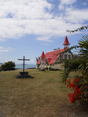 The first thing that comes to mind when we speak of Mauritius is a postcard picture of a sandy beach and a palm tree; but Mauritius also has other great things to offer. Here is a snapshot of my one-week stay in this little paradise.
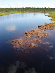 Estonia, a small country in north-eastern Europe, has neither grand landscapes of deep canyons, breathtaking mountains nor even proper uplands. The highest point of Estonia, and the Baltics – the Big Egg ‘mountain’ – is only 318m above sea level. Nonetheless, the country is a real treat for nature lovers and walkers with wonderfully bucolic and wooded scenery. About half of Estonia’s territory is forest, inhabited by many animals that are very rare or no longer found at all in western Europe, like wolves, brown bears, wild boars and lynx. Its national parks are great for wildlife spotting, and especially birdwatching, due to the country’s key position on north-south migration routes.
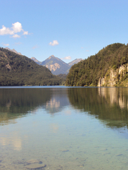 The Bavarian Alps are probably the most popular tourist destination in Germany and it’s easy to see why. In winter, the region attracts with its skiing resorts, while in summer the Alps are great for hikers. There are pristine lakes, forests, beautiful baroque churches and fairytale castles, with King Ludwig II’s Schloss Neuschwanstein being the unparalleled favourite.