 IGN is France’s national survey agency, the equivalent of Great Britain’s Ordnance Survey. As the Ordnance Survey was, and as many national Géographical institutes still are, it was originally a department of the army. It became a public institution just before the Armistice of Vichy in 1941.
In its new status one of IGN’s first responsibilities was to set up a network of markers indicating positions on the ground and covering the whole of the French territory. This, the New French Triangulation (NTF), allowed an accurate measurement of the shape of the land. The NTF was complemented by a levelling network that provided improved accuracy in the measurement of altitude. These two networks are still used and maintained today alongside the latest GPS (Global Positioning System) technology.
The first maps available to the public were the Cartes d’Etat-Major (Staff Maps). They kept the name and scale, 1:40,000, they had when IGN was still a department of the army until they were replaced by the 1:50,000 scale series a few decades later.
The years between 1960 and 1985 can be defined as the African Years for IGN as they undertook the mapping of most of the French-speaking countries in Africa.
The ’80s and ’90s saw the ascent of computers and for IGN, the creation of the first database, the BD TOPO© (Topographic Database). The 1:25,000 and 1:50,000 scale series are derived from this database; the 1:100,000 and the 1:250,000 are as well but they are the result of generalisation, which is the removal of detail to increase legibility.
Another 15 databases were created after this first one. Among them, the BD ORTHO© covers part of the French territory with Orthophotographs (aerial photographs in which all distortions are corrected) and the BD ALTI©, which is composed of spot heights regularly spaced out and allows the creation of a model of the ground.
The maintenance of the geodetic and levelling networks and the production of up-to-date topographic maps are IGN’s first concern but the range of its activities is very wide. Based on its 60 years’ experience, IGN has been called upon for projects such as the assessment of historical buildings (measuring subsidence, etc.) or for the building of the Amsterdam underground.
IGN has a formal working group dedicated to researching the meaning and the circulation of placenames that appear in IGN publications. IGN also houses the ENSG (National School of Géographical Science). It is responsible for the training of all of its engineers and technicians and many foreign students and professionals attend its prestigious courses.
The public knows very little about IGN’s wide range of activities but it is the commitment to these activities that guarantees the quality of products such as the immensely popular 1:25,000 maps, the bedrock of IGN.
Stanfords stocks a huge range of IGN maps covering every region of France and to suit every purpose:
Author: Jacob Genelle
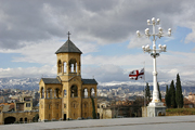 Looking for somewhere different that is neither quite Europe nor Asia? Georgia in the Caucasus is a lot more than mountain tribes with wool hats – though you can find these as well among the 5000m-high Caucasus peaks.
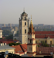 Vilnius, the Lithuanian capital, is a hidden gem. A very pleasant city with an extensive Old Town to explore, parks, castles and a few surprises, like the Frank Zappa Memorial (and why not?) and the run-down artists’ quarter of Uzupio. You might even be lucky and arrive at the right time, as on certain weekends Lithuanians like to dress up in traditional costume and gather in parks and town squares to sing and dance, asserting their national identity.
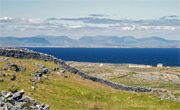 The largest of the three Aran Islands, Inishmore, can be reached by ferry from Rossaveel (or Galway) on the Connemara coast. You can see most of the island in a day trip, though I wished I’d taken more time to absorb the grandeur and isolation of the place. There is only one road running down the island’s length, and there are minivans, bicycles or horse drawn carriages to hire in the harbour at Kilronan.