Mississippi is a difficult word, especially for a non-native English speaker like me. All those double consonants are impossible to memorise – only after some years did I learn how to spell it. It is also one of those names which fires up your imagination. When I was young I looked at maps of the USA, and this great river always caught my attention. Then there were books (anyone remember Huckleberry Finn or Tom Sawyer?) and movies which placed the Mississippi deep in my subconscious. Finally this summer I decided to visit central USA, including the Mississippi River.
I started my trip in a rather unusual place – Davenport, Iowa. Now, it is not where most people would start travelling alongside the Mississippi. Iowa in general is not a state where tourists go in droves. In my case, I had to cross it on my way from the Great Plains of the Dakotas and Nebraska to the Great River itself. Davenport didn’t look like a city worth stopping at (apart from a night in a cheap motel) so I immediately crossed to Moline, Illinois, which I would probably would’ve passed as well if I hadn’t got lost…
 But let’s start from the beginning. I got off the highway to stop at the Illinois Welcome Center. Most states in the US operate tourist information centres alongside the major interstates. They are usually real mines of useful, as well as completely useless, information, brochures and glossy magazines. After getting all I needed, I tried to go back to the interstate 80 but somehow ended up in Moline. Driving up and down trying to get back to the highway I found a place called The John Deere Pavilion. John Deere is one of the great American icons. In the Midwest, a John Deere baseball cap is as important part of local clothing as the Stetson hat is in the American west. The pavilion itself, apart from the great gift shop full of toy machines and clothing, offered the chance of getting inside some seriously big machines. Where else could you try how it feels to sit in the driver’s seat of a combine harvester or a 8345RT tractor with caterpillars instead of wheels? If you have even a bit of child left in you, don’t skip this place!
 From Moline I used main roads that were away from the river to get to Hannibal, Missouri where the real trip along the Mississippi started. Hannibal is a small, quintessentially American town, famous for being the place where Mark Twain grew up. The town became the inspiration for the fictional town of St Petersburg in The Adventures of Tom Sawyer and Adventures of Huckleberry Finn. Nowadays the biggest attractions in town are those connected to the great writer himself, like his boyhood home, a museum, and the J M Clemens Justice of the Peace office (Twain’s father’s office). The best way of experiencing the town is to wander aimlessly around its few streets, enjoying the lazy atmosphere. South of town there is a viewpoint on top of the high bluff which offers great vistas of the Mississippi valley and the town of Hannibal itself. Similarly good views can be found north of downtown from the top of the lighthouse. Yes, there is a lighthouse in Hannibal, thousands of kilometres from the nearest ocean.
The best way of following the Mississippi is to drive along the Great River Road, a well-marked scenic byway, running along almost the entire length of the river. It uses local, county and state highways on both banks of the river, as close to the water as possible. Navigation is made easy by road signs with ship’s wheel symbols, but it helps to have a detailed map as this road can be a bit more complicated than you might expect from a popular tourist route. I decided to follow the eastern branch of it, which offered a taste of the real rural Illinois: fields, farms, small towns, lush greenery, and heat.
After passing the towns of Quincy and Warsaw, I arrived at Nauvoo. It is a small town, with a population of few more than 1,000, but historically it’s quite important. In 1839 a group of Mormons settled there. Among them was Joseph Smith, founder of the religion, and Brigham Young, who after the death of Smith led Mormons west to the Utah territory. Because of its importance to the Mormon religion, you can probably see more Utah licence plates here than anywhere else outside of Utah itself. Today Nauvoo is a very well-preserved town with a number of historic houses and local businesses looking almost exactly as they did 160 years ago. There is also a replica of the historic Mormon temple, which was built in 2002 but looks identical to the original one.
North of Nauvoo I continued along the Great River Road, but it wasn’t the most spectacular stretch. The land was flat and I couldn’t see the river from the road as it was hidden behind the tall levees. I spent the night in some forsaken campground where mosquitoes wanted to eat me alive.
 In northern Illinois things got much more interesting again. High bluffs appeared on both banks of the river with the road squeezed between them and the Mississippi itself. One of the best places to explore this varied topography is the Mississippi Palisades State Park, where short hiking trails lead from parking lots to scenic viewpoints. You can see the river valley stretching for miles north and south. Apart from the spectacular topography, northern Illinois (and Iowa on the western bank of Mississippi) offer some interesting small towns such as Fulton, Clinton, Savanna and –Iocated on an island in the middle of the river – Sabula.
The most famous of the towns is actually a few miles away from the Mississippi. At its peak in the mid-19th century, Galena was a booming mining community with a population of 14,000. Now with only 3,500 inhabitants, it is a much quieter place. Its downtown is almost completely preserved and is full of historic houses and churches located on the hilly terrain. One of the main attractions is the home of general Ulysses S Grant, the civil war hero. The town is perfect for lazy strolls, doing some shopping or having a nice meal. It is also very photogenic, but take note that the best time to take pictures is in the earlier part of the day as the town is located mostly on the north-western slopes and in the afternoon you will have the sun against you.
 After Galena I left the Mississippi River valley for a while and moved inland to southern Wisconsin. My destination was the town of New Glarus. As its name suggests, it was established as a Swiss community. Even today, in the countryside surrounding the highway leading there, you can spot farms proudly displaying Swiss flags next to the American ones. The town itself offers quite a bizarre experience with some pseudo-alpine buildings located downtown. In some moments you can get really confused; are we still in America? But all this unashamed commercialisation hides a community with a really interesting history. You can explore it in the Swiss Historical Village which preserves some original wooden buildings from the early pioneer times. Afterwards you can have a pizza in pizzeria Ticino, which looks exactly like it was moved from the Alps.
After continuing my detour to Madison, where I visited the Wisconsin State Capitol (the fourth capitol during my trip this year), it was time to get back to the river. In Wisconsin the Great River Road follows state highway 35 and is a really spectacular drive. One place which you definitely shouldn’t miss is Wyalusing State Park at the confluence of the Mississippi and Wisconsin rivers, just south of the Prairie du Chien. It offers truly spectacular views from the 150m tall bluffs, on top of which you can find prehistoric Indian mounds. The campground in the park has some of the best tent sites I have seen in my life. They are located right on the bluffs’ edge so you can have spectacular views practically from your tent. Unfortunately they have to be reserved in advance, so I couldn’t stay there. And that caused other problems; there was some convention or gathering going on the weekend I was there, so all the hotels in Prairie du Chien, and also in the town of McGregor on the Iowa side of the river, were full. I ended up driving over 20 miles west, deep inland to rural Iowa, to the town of Postville where I stayed in the worst motel I have experienced in my life – dodgy, dirty, creepy, with bad service and not as cheap as you would imagine.
 Anyway, the following morning, the weather was great and I got back to the river in a good mood indeed. North of Prairie du Chien lies the best part of the Mississippi Valley. Almost all the way to the outskirts of St Paul (about 200 miles away) you encounter one amazing vista after another. The valley is also dotted with tranquil small towns like Ferryville, Genoa, Stockholm, De Soto and Alma, which usually contain just a few houses, a bar or two, a local shop and sometimes a gas station, squeezed between the bluffs and the river. It is also fun to cross the river on the steep, narrow steel bridges linking Wisconsin with northern Iowa and southern Minnesota. Especially for a road and bridge geek like me, it is like paradise.
One of the best spots to enjoy great views of the Mississippi valley is Garvin Heights City Park in Winona. Located just off the US Hwy 61, this viewpoint offers an amazing vista of Winona, which is located in the middle of the valley, and the surrounding countryside. Equally good views can also be found from the Wabasha Overlook on the outskirts of the town of Wabasha, a few miles up the river. The difference is that you can drive to the viewpoint in Winona but you have to climb to the one in Wabasha.
From Wabasha, the Great River Road continues towards St Paul, passing a string of small towns like Lake City (where I can recommend a great campground), Red Wing and Hastings in Minnesota, and Prescott in Wisconsin. As I got closer to St Paul and Minneapolis, these small places became more gentrified. Cafes got trendier (and fuller of people showing off their laptops), galleries more common, and instead of pick-up trucks you could spot more flashy cars (even some European ones!) It’s all nice but lacks the authenticity and grittiness of places located further south. Finally I ended my trip in St Paul. It is the capital of Minnesota so I could add another state capitol to my growing list.
It was my dream for many years to follow the Mississippi river. I read the books about it, explored maps, watched movies… And I have to say, I wasn’t disappointed seeing it in reality. The Mississippi valley offers spectacular topography, nice small towns, interesting history and friendly people. What else do you need for a great holiday?
During this trip I used Moon handbooks to: Mount Rushmore & The Black Hills, Illinois, Wisconsin and Minnesota. They are really packed with useful information. For navigation I used DeLorme Atlas & Gazetteers. They are published for each state and were most helpful when I was exploring small county highways alongside the Mississippi river; especially in Illinois and Wisconsin.
Author: Gregor Swiderek
- Browse our collection of maps, guides and travel literature:
- > USA travel guides
- > USA road maps and atlases
- > Travel literature inspired by the USA
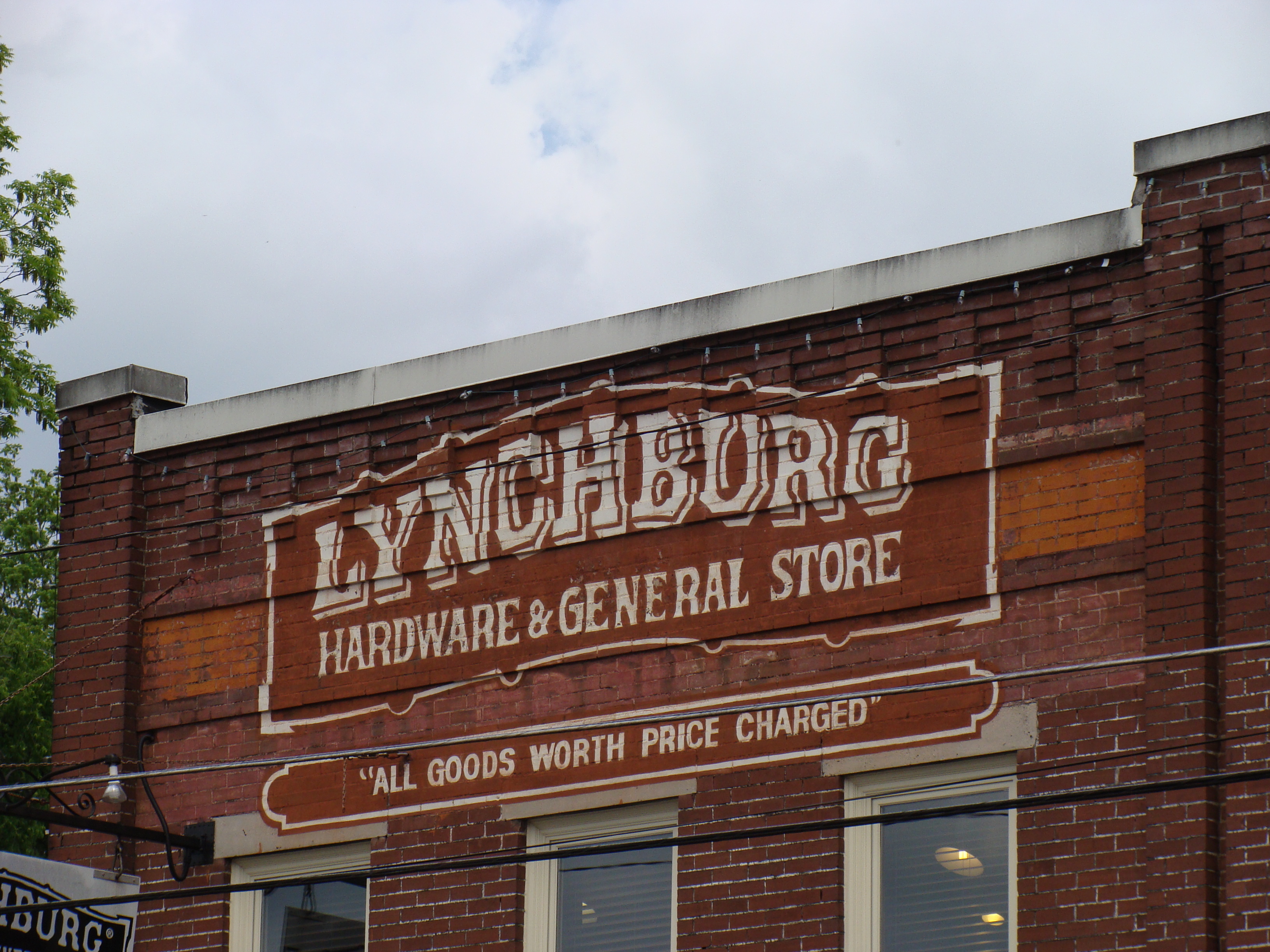 My latest adventure started in Atlanta but I left it as soon as I had landed and headed north towards Tennessee as I wanted to explore some positively rural corners of the south. After quite a pleasant drive (including an overnight stop in the fantastically named Chattanooga) I got to the first place I planned to visit during this trip, the town of Lynchburg. This small city, located in the rural heart of Tennessee, is home to one of the best known brands in the world, the legendary Jack Daniels. Of course the J.D. distillery (located just east of town) had to be my first port of call. I’m the sort of guy who likes visiting mines, factories and all sorts of strange industrial places, but this distillery is a great place for anyone to visit.
 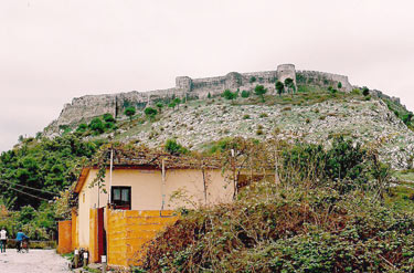 The hotel receptionist was vague about the early bus to Shkodër. That or she just thought I was mad to want to catch a bus at 7.30 in the morning; she thought there was one at about 1pm instead. From past experiences, I’ve learnt to pay attention to this kind of oblique advice so, instead of getting up early and rushing off for a potentially non-existent bus, I had a leisurely breakfast and went for a coffee and final wander along Durrës’ sea front. I needed to get to Shkodër in North Albania to then be able to cross over into Montenegro. What’s more, Shkodër is overlooked by a huge and ancient ruined castle, the Rozafa Fortress, that I wanted to explore.

 Choosing a mode of transportation is one of the most important decisions when you are planning your trip. Technically, you don’t have to rent a car, but let’s be straight and honest: public transport in the US sucks and if you don’t have a car your mobility will be greatly reduced.
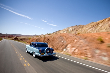
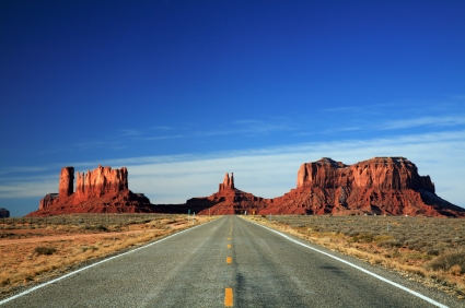 Next thing to decide is the type of car you want to rent. Of course, it all depends on how many people are travelling with you but remember that American cars in any given class are larger than their European equivalents. Having said that, I never choose the smallest class or two, even when I travel alone. There might be enough space inside but you can feel that such cars are good enough for shopping drives in the cities but not for the proper long journeys on the American highways. No, thank you very much. Also remember that when you book a car you book a vehicle from a given class but not the specific model. So booking “Mustang or similar” usually means the similar one, not the Mustang itself. Fortunately, if you have a bit more money available some companies offer booking specific models. For example, Hertz offers bookings for Mustangs and Camaros specifically on its website. It also pays to ask at the rental desk if there is any upgrade available. Sometimes for a little bit extra you can get some really nice cars (that’s how I managed to drive a Ford Mustang for the first time). Never pay for options you don’t need; agents often push for some extra insurance options because it is the way they make the extra money. Also don’t pre-purchase an extra tank of fuel. Normally you get the car full and are supposed to drop it off full. Agents often try to up-sell you the option of dropping the car off empty. It doesn’t make sense as the price of fuel they offer is not really competitive and you will never drop car off totally dry. Also think twice about the satellite navigation system. All the companies offer them as extras, but often you will be better off buying your own rather than renting one, especially on longer trips. Alternatively, nowadays you can easily use your smart-phone for navigation. I myself as a traditionalist and map lover use paper maps and atlases. They give me greater spatial awareness than just dumbly following the instructions of a sat-nav.
 This is a long and changeable subject, but let me try to cover some of the basics. I travel to the US mostly from the UK, so information here will be most relevant for those travelling from Britain but I will try to cover some universal basics.
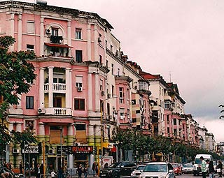
 America is, in a way, a country designed for people on the move. That’s probably why it is one of the places where finding a place to stay is ridiculously easy. But still, let me give you some tips.
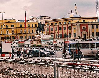
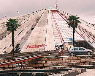
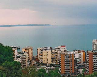 Albania is not often on anyone’s itinerary but it is an intriguing and quite beautiful country to visit. I came across by bus from Orhid, Macedonia, and my destination was Tirana, the capital. Once the border crossing had been negotiated, which involved changing buses, helping a garrulous old woman with too much baggage, and being entertained by some blatant bribing of a customs official by a truck driver in a hurry, the bus was on its way.
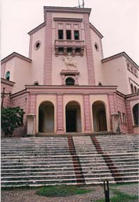 Although I am an archaeologist by profession, my interests have become somewhat warped into a fascination for derelict buildings and politically-controversial heritage. The highlight of my stay in Durrës wasn’t then so much the Roman Amphitheatre and other archaeological ruins that dot the centre of the city, as interesting as they are, but King Zogu I’s villa. Perched on a, now built-up, hill above the city, with splendid views out across the bay and the sprawl that is modern Durrës, is the grand but derelict house. It is surrounded by a high wall with the gateway blocked by great rolls of tangled barbed wire. I was standing there contemplating if there was any way I could get in when I heard a whistle. Looking up I saw a man leaning on the wall above. He asked if I wanted to come in and then disappeared, reappearing the other side of the barbed wired entrance a few minutes later. A metal bar through the tangle meant he opened it up with ease and let me in. We walked back up the drive in silence until I tentatively asked ‘anglisht?’ in my best non-existent Albanian. He shook his head and suggested ‘Italian?’. When I responded ‘Ireland’, he beamed a smile at me, shook my hand a second time and cheerfully said ‘Belfast!’… With which he waved me up the grand steps to the house and returned to his well-worn chair by the wall.
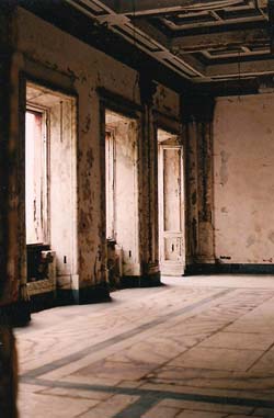 Even with the vandalism and decay – peeling paint, crumbling plaster, not a door or window surviving and all the fixtures and fittings long since ripped out – the grandeur of the place is still evident. From the full-height hallway is a marble staircase that divides in two and curves up to take you to some huge and grand rooms with marble floors, compartmentalised and moulded ceilings and long windows that look out over the bay. I wandered through rooms and up and down staircases, crunching over bits of fallen plaster and avoiding holes, imagining what it may have been like. A storm was brewing over the bay – the rumble of distant thunder and the dramatically darkening sky over a steely grey-blue sea adding a foreboding atmosphere to the derelict and empty house.