 Our journey started on a rainy, cold and generally miserable April morning in London. But after just a few hours we landed in sunny and even hot Washington. Washington Dulles Airport is quite unusual – between the jetties and main terminal building there is no fixed connection. You have to board funny vehicles which are a cross between bus, truck and fork-lift. Even with such added “attractions”, the whole process is much faster and easier than I have ever experienced at Heathrow. A few minutes after clearing immigration we collected the keys to our car. Continue reading USA – South-East Road Trip
Category: We’ve Been There
Stanford’s travel tales from our in-house travel experts.
Walk of the month: Southstoke and Cam Valley, Somerset
 Christopher Somerville works from home as a writer and journalist, looking out across a wide and stunning view that takes in much of north-east Bristol and over to the hills near Bath. So although he lives in and enjoys the city there’s always a view to the hills and the landscape which provides the inspiration for his many books and newspaper articles.
He says, “Bristol is an excellent place for a walker to live – 40 minutes travel in any direction takes you to a diversity of countryside; from Somerset Levels to the Welsh Hills, and from the greatest light show on earth (yes, the sunset over the Bristol Channel) to the pretty villages and valleys of the Cotswolds.”
Here is the first in a series of walks he will be compiling for Stanfords’ readers to follow in the Southwest each month. Continue reading Walk of the month: Southstoke and Cam Valley, Somerset
24 Hours in SF
 I visited San Francisco in 2001, during my first visit into the US, when it was the final stop during our cross-country drive all the way from Florida. It was a bit of a crazy trip, on a ludicrously low budget, and the route was the result of a compromise among all five of us. Someone wanted to visit New Orleans, another person wanted to see the Grand Canyon and someone else Las Vegas. For my part, I wanted to visit San Francisco. So we went.
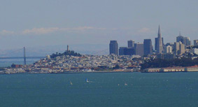
And that’s how, after 10 days and well over 5000 km of driving, we finally approached the famous city. Luckily (and totally unplanned), we approached it via the impressive Bay Bridge which offers one of the best vistas of the downtown SF. The Bay Bridge, connecting SF with Oakland, is a real marvel of engineering and an attraction in itself, especially for anyone interested in engineering and impressive constructions, like me. The bridge consists of two major crossings connecting each shore with Yerba Buena Island, a natural outcrop located mid-bay that is part of the city of San Francisco. The Western crossing lies between Yerba Buena and the rest of San Francisco and it is composed of two complete suspension spans connected at a center anchorage. It is also a double-decked bridge and, driving into SF, you travel on the top deck which guarantees some really splendid views.
We were driving in the late afternoon, just a short time before sunset, so the view was as good as you can get. Especially amazing was the fog from the Pacific rolling over the hills and approaching the city. It looked like a massive wave trying to engulf it.
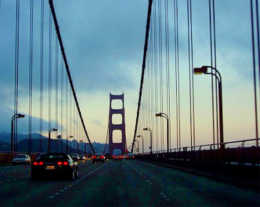
Entering San Francisco via Bay Bridge you drive right into the center, literally on the rooftops of the buildings. It feels crazy. Our plan was to spend the night camping north of the Golden Gate so we had to leave the freeway and cross the city on the way to the Golden Gate Bridge. It was evening rush hour and driving and navigating was a nightmare. As a geographer and map enthusiast, I was responsible for the navigation. I was trying to follow our progress and plan the route on a tiny inset map of downtown SF in our USA road atlas, but it wasn’t easy and I still feel sorry for my driver friend who had to follow my messy and usually late instructions. Fortunately we reached the world famous bridge without a scratch or getting seriously lost.
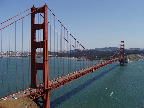
The Golden Gate Bridge is one of the icons of San Francisco, California and probably even the whole USA. For me, crossing it was probably the climax of our journey, which in itself wasn’t short of landmarks by any means. However, it was getting dark and we had to find some campground, so there was no time for admiring the views. Using the same battered road atlas, we were trying to locate campsites in the Muir Woods National Monument when we got lost. The seriously hilly Marin County lies just north of San Francisco, right across the Golden Gate Bridge, and is covered by a really chaotic web of narrow and curvy roads leading to many of the most expensive houses in America. I still don’t know how we finally managed to find the campsite in total darkness.
When we got up the following morning we had the chance to experience the famous dense fog which so often appears in the Bay Area. I have to say that our forest campsite looked really magical in such circumstances, with rays of light beaming between the massive trees and illuminating fog in some really crazy ways.
Soon we were crossing the Golden Gate again on the way back into San Francisco. Opened in 1937, it is in my opinion still one of the most beautiful bridges in the world. Actually, I think it is probably one of the most beautiful man-made structures ever built. I know it sounds a bit exaggerated but I really love this bridge and so will you once you see it yourself, especially on a beautiful sunny day.
A short time later, after leaving the car in some ugly parking structure, we finally started our exploration of the city. And what a fantastic city it is. You simply can’t beat its location. Surrounded by water on three sides, it contains around 50 hills within the city limits. It is also the second-most densely populated large city in the United States after New York City. And for all that we had only one day.
With such a short time available the best option was simply to walk around without much plan, to immerse ourselves in this eclectic and diverse city. It turned out to be a great idea and I had a really good day.
But San Francisco has so much more to offer. Right next to Chinatown, in a neighbourhood called Financial District, is located one of the most iconic skyscrapers in the US, the Transamerica Pyramid. Built in 1972, this 260-meter building is also the tallest in San Francisco. Don’t worry, you won’t miss it due to its four-sided pyramid shape, which is in fact so unique that it was only recently that the Shard building in London adopted a similar design.
Heading north, I entered another interesting neighbourhood, the North Beach, which has historically been home to a large Italian population. Nowadays, due to white flight, and gentrification, the neighbourhood has seen its native Italian American population rapidly shrink but it still retains an Italian character with many Italian restaurants, cafes, and bakeries that line Columbus Avenue and Washington Square. Here I also visited a lovely small bookshop, full of maps and travel books, but it was so long ago that I can’t remember its name or location. I was trying to find it on the internet, but to no avail. Maybe it closed like many other small independent bookshops? That would be sad.
We kept walking around the city for hours. Other points on our route included some of the San Francisco piers, right next to the spectacular Ferry Building, located at the Embarcadero, which offers great views of The Bay Bridge, and later a steep climb to Russian Hill. And I really mean steep. It is so steep that one-block section of Lombard Street consists of eight tight hairpin turns. They are necessary to reduce the hill’s natural 27% gradient to somehow more of a manageable angle. In general, walking in San Francisco involves a lot of climbing due to all these hills. Many streets are so steep that they even have steps rather than simply walkways.
By the end of the day we were all exhausted. All this climbing really got into our legs and it was time for us to leave. We left the spectacular city of San Francisco less than 24 hours after initially crossing the Bay Bridge and started our 5000 km long drive back to Florida.
And if you ask if it was worth driving around 10000km in total to see it, I can definitely and loudly say yes.
- Browse our collection of maps, guides and travel literature:
- > USA travel guides
- > USA road maps and atlases
- > Travel literature inspired by the USA
Planning a Trip to the USA- Route planning
 Before you go to the USA it makes sense to do a bit of homework and planning. Remember, it is a huge country: for example the distance from New York City to Los Angeles is 500km greater than the one from Lisbon to Moscow. So you should know what your priorities and also your limits are.
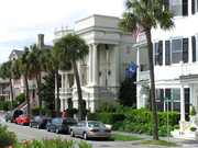
Are you interested in nature or maybe in the cities? Do you like big, cosmopolitan places like New York, Los Angeles, San Francisco and Chicago, or maybe small charming colonial towns like Charlestown and Savannah? Do you prefer lying on the beach or maybe hiking in the mountains? The tropics or the Arctic? America has it all.
First thing you have to decide is how much time you have and what your budget is. If you only have a week and a few hundred bucks, it doesn’t really make sense to drive from coast to coast. It is of course perfectly doable but you will feel more like a long distance truck driver than a tourist. Also, as you will have to stick to the main highways, your experience will be limited to the fast food chains, and gas stations. Is it really what you want? In my opinion, 10 days, or even better 2 weeks, is the absolute minimum for a cross country trip.
Let’s say your choice is a cross-country trip. The planning doesn’t end here, however. There are of course countless routes you can choose. Many people do the classic cross-country trip from NYC to LA or San Fran. That way you can experience the big cities of both coasts as well as the American hinterland. You can for example travel from NYC to Chicago and then follow the famous (if a bit overrated) route 66. Or you can head in the direction of Denver and cross the magnificent Rocky Mountains in Colorado. Another option is heading even further north towards Montana or Wyoming to visit the Yellowstone National Park. While planning you should also consider the weather. If you travel in the winter, choosing a southern route, from Florida to southern California, might be the best option. That way you avoid the risk of being stuck in cold and miserable weather further north and you might even experience New Orleans during the Mardi Gras. However, if you happen to go during the heat of summer the northern route from New England towards Seattle might be a more tempting idea. Myself, I would always avoid the sweltering humid south in the summer.
Crossing the continent is obviously a fantastic idea. But by no means is this the only option for the great American experience. There are a few other fascinating routes, most obviously the coasts. The west coast offers absolutely amazing scenery and it is probably one of the most scenic drives on earth. And not only the famous Big Sur in California but also most of the Californian coast north of San Francisco as well as, my favourite, the Oregon coast. East coast might be not as spectacular (apart from Maine) but it offers a rich colonial history. Think of Boston, NYC, Philadelphia, Savannah, Charleston and many more historic places. One more interesting north-south route is obviously the Mississippi River. It offers a great mix of spectacular scenery (especially in its northern half) and cultural sites. Big cities like Minneapolis, Saint Louis, Memphis and New Orleans as well as small interesting towns like Vicksburg, Natchez or Hannibal all line the river.
All the routes mentioned above require flying in and out of the different airports or lengthy backtracking. For those who don’t want to do either, choosing a particular region of the US and doing a loop around it might be a better option. It simplifies logistics as well as makes the trip significantly cheaper (avoiding drop-off fees on your car rental). There are few distinctive regions begging for a specific trip. The most obvious ones are Florida, California, South-western USA and New England. My other favourite options include the Carolinas with Georgia, the Great Lakes, the Great Plains or the Pacific Northwest, which is probably my absolute favourite part of the USA.
Once you choose where to go, do a bit of researching what you really want to see there and how much time you need for it. I usually do the region-specific trips. In such cases, I choose some highlights and use online route planners to check how long it will take me just to drive between them. That way I know that I won’t overstretch myself trying to cover too much ground and that I won’t be budgeting too much time for some closely located sites. Google Maps or Map Quest are the most obvious route planners but there are many more. At this point I usually start looking for flights. Each of the regions mentioned above has at least one large hub airport which offers cheaper fares and sometimes even direct routes from Europe. But this is a subject for another chapter.
- Browse our collection of maps, guides and travel literature:
- > USA travel guides
- > USA road maps and atlases
- > Travel literature inspired by the USA
Author: Gregor Swiderek
Budget Nightlife Guide to NYC
 New York City seems to be always on the move, from the early morning rush to late into the wild nights. Unfortunately for the budget traveler, it can be a very expensive night out. However, if cheap accommodation in the Big Apple exists, so do cheap bars. You’re sure to find affordable fun. The city is vibrant and diverse, so your choice of nightlife depends on the kind of entertainment you’re looking for.
Cheap Bars and Happy Hours
If you’re looking for a centrally located bar that won’t break your wallet, look no further than Old Town Bar and Grill at Park Avenue and Broadway for cheap food and beer. Of course, there are many more places that can compete. Welcome to the Johnsons is an attractive option for its long happy hour from 1 to 9pm, when drinks are $2 and finger food is free. Or you can check out Acme Bar & Grill for their $2 specials (they also have themed days, like Wednesday’s “ladies two for one”).
A slightly more expensive option is Fiddlesticks on Greenwich and Seventh, whose Monday to Friday happy hour lasts until 10pm, during which time everything costs $3. On the East Side look for Bravest, with their $1 pints of beer during happy hour. Or even better, on the Upper West Side you’ll find the bar Bourbon Street, which offers 50 cent beers until 11pm! Though, the king of them all has to be Crash Mansion, which has free well drinks from 9 to 10pm, just remember to RSVP at with your name to New York Underbelly!
Concerts and Clubs
For live shows, you can expect to find cover charges averaging around $20, but don’t let that get you down. You have options. The West End is a sweet university-crowd place that has bands every weekend, and no cover. Arlene Grocery is another bar with nightly live music for only $3 cover. Madame X has free jazz from Sunday to Wednesday, and DJs at the weekend for which they only start covering $5 after 10pm.
The biggest dance clubs also charge covers that can be anywhere from 10 to 30 bucks. Keep an eye out for deals, like the ones you can find through Webster Hall’s e-mailing list. . There are some smaller, cheaper clubs as well. Venue has three dance floors and no cover. Sapphire is smaller but with a great music selection and only covers $5 after 10. Polly Esther’s charges $8 at the door, but it’s a great 70s and 80s music club. For beautiful people watching, Meow Mix only covers $5 and offers a great party.
Theatre and Burlesque
Perhaps you will have decided to begin your night with 99 Cent Pizza, the cheapest pizza you’ll find in the night, which is behind the Port Authority. From there you’re set to enjoy a sit-down night enjoying a show.
If it’s comedy, head to the Comedy Cellar. All the big name standup artists perform there, and you have a chance to avoid the cover charge by checking out their website. If it’s burlesque you want, look no further than Mr. Choade’s Upstairs/Downstairs at The Slipper Room. It’s only $5 cover.
Finally, if its theatre you want, take these suggestions to heart. Look for deals online for the big shows, if that’s what you’re after, but know that there are dozens of lesser-known theatres. Buy tickets for their shows at Times Square’s TKTS discount ticket booth. Also, keep an eye out for student deals or standing room only tickets. Another good option is to sign up for the newsletter at nytix.com.
- Browse our collection of maps, guides and travel literature:
- > New York travel guides
- > New York road maps and atlases
- > Travel literature inspired by New York City
France – Côtes-d’Armor, Brittany
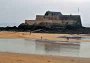 Our cycling trip began with an overnight ferry from Portsmouth to St Malo, and after this sleepy start, we began in earnest – cycling off the ferry onto French soil where we’d spend the following week pedalling past the beautiful coastline, canals and villages of north-east Britanny.
But that early morning start in St Malo took us by surprise – believing we were invincible, we suddenly realised that we had taken a wrong turning at a roundabout and were heading north rather than our intended south. So, for the remainder of our trip, we decided we would make full use of a map and the IGN cycling map for this area was a godsend, helping us to plot our route each day and plan where we would pitch our tents and buy our food and locally produced cider.
Leaving St Malo, we headed due south to follow the course of the Ille et Rance Canal, visiting the grey, yet pretty Dinan and small towns such as Tinténiac and Hédé, where we set up camp alongside a lock-keeper’s cottage. The next day, heading north-east through forests and agricultural land, we reached the hilly town of Combourg, which had a resplendent palace and fine French cuisine.
After refuelling in Combourg, we headed in the direction of Mont St Michel. Prior to our arrival, the steep slopes downhill allowed us to rest our legs and take in the magnificent views of Mont St Michel in the distance. The place is beautiful, full of history and definitely worth a visit – but I wouldn’t recommend taking your bike there, unless you want to push it all the way up to the cathedral, through groups of British schoolchildren, along the steep, narrow streets of the island.
The remainder of our cycling adventure followed the coastline back to the ferry terminal, taking in Dol-de-Bretagne (where there is a hill-top belvédère, or viewpoint, from where you can take in the sights of the surrounding villages and countryside), Cancale (excellent beaches and seafood) and St Malo, which is definitely worth visiting for its port atmosphere, old streets and shops and restaurants. You could even try the town’s specialist absinthe bar, if you really want to derange your senses.
For a trip to this area of France, I would definitely recommend referring to the Rough Guide to Brittany & Normandy and the Rennes-Granville IGN 1:100,000 road map.
- Browse our collection of maps & guides:
- > France travel guides
- > France road maps and atlases
- > Travel literature inspired by France
Author: Tim Cleary
Costa Rica
La Patita de Manzanillo
Two friends and I were staying in a holiday house in the middle of jungle, yet near the beach, in Manzanillo, a small village that locals refer to as ‘the end of the road’, and it quite literally is. It’s right down the bottom of Costa Rica, on the Caribbean coast, nearing the border with Panama.
Having endured some hard days of travel – my friends had come up from Panama, and I had spent about two days travelling from the UK – we were thrilled to arrive at La Patita, a beautiful house sensitively designed and built with native hardwood, situated amongst the coastal jungle, with very little other construction for company. Continue reading Costa Rica
Argentina – Climbing Aconcagua
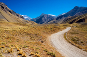 ‘Felices Navidad!’ hollered the voice at the end of the distorted phone line. Irritated at having Christmas lunch disturbed, the family was instantly placated by the sound of my brother’s voice coming down a satellite phone from camp one, high on the flank of Aconcagua.
He was a member of the Walon UK & Toyota (GB) plc team of four that, in association with a commercial company and eight others, was attempting to scale the ‘Stone Sentinel’ by the Normal Route in aid of the charity Wooden Spoon. Continue reading Argentina – Climbing Aconcagua
Argentina
 Since the collapse of the Peso, Argentina has gone from the most expensive country in South America to one of the cheapest. This has made Argentina into a hot destination for budget travellers for the first time.
I never made it to Patagonia, because it was winter, but I had a great time in Buenos Aires – a sophisticated European-style city with great food (if you’re not vegetarian), and great nightlife.
Domestic flights have suddenly become a bargain, so you can go to the far-flung corners of this vast country quickly and cheaply. I flew to Salta, a pleasant colonial city up in the foothills of the Andes. From here you can bus up to Bolivia through the back door and acclimatise, unlike flying in to La Paz at 4,000 metres (apprx 13,000ft).
Footprint are the experts in South American travel. The Footprint South American Handbook is great and the Footprint Argentina Handbook is far better than its rivals. As for maps, we stock a range of road atlases, street plans and detailed maps of Patagonia imported from Argentina and Chile.
- Browse our collection of maps, guides and travel literature:
- > Argentina travel guides
- > Argentina road maps and atlases
- > Travel literature inspired by Argentina
Author: Guy Bristow
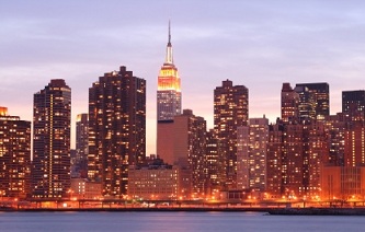
12 Hours in Manhattan
 For most people, the city of New York is one of the major destinations in the US, but for some reasons I was never particularly drawn to it. Still, as it was on our way back to Boston, we decided to give it a go.
We spent the night in one of the countless and totally indistinguishable suburbs of the great city. Here, it makes sense to point out that such suburbs are home to the majority of the metropolitan New York population. All the hippies and cool folk of Greenwich Village, East Village and SoHo are actually far less representative New Yorkers than people working in McDonald in Bronx or driving delivery vans on the New Jersey side of the Hudson River. Anyway, we had only one day and decided to get the most out of it.
It was Sunday morning, about 9am, when our frenetic 12 hours in Manhattan began. We entered the island of Manhattan via George Washington Bridge which is located at its northern end. To be honest, it is a far less spectacular approach than some of the others, but it didn’t really matter as we quickly made our way towards one of the highlights of the city, the Central Park. Well, to be honest, it wasn’t really that quick at all because we had to park our car first. And it is not an easy task in NYC, even on a Sunday morning. Anyway, we finally managed to squeeze it into one of the smallest and most claustrophobic underground parking garages I have ever seen in my life. However, located on 96th street, it was just minutes from the park. But before we managed to reach the park, we unexpectedly got caught right in the middle of a street party. The road was closed to traffic and, even early in the morning, full of people enjoying themselves. I later learned that it was probably the Annual Upper Broadway Autumn Festival. Or maybe not? It doesn’t really matter; it was fun.
Finally we reached Central Park. Here I, must admit that I absolutely love it. I find this perfectly rectangular bit of tamed nature, located right in the middle of one of the most densely populated cities on earth, absolutely fascinating. Whenever I looked at the map of Manhattan I always wanted to visit it.
Covering 843 acres (341ha) of almost entirely landscaped land, it was designed by the renowned landscape architect, Frederick Law Olmsted. If you ask me, he did an amazingly good job. The park looks really natural in its appearance and it is much more heavily wooded than, for example, Hyde Park in London. In places it might sometimes be possible to forget that you are really in the middle of a teeming metropolis. But on Sunday, around 11am, the whole park was full of people and you would know you were in the city. They were jogging, cycling, rollerblading, skateboarding or just walking with or without dogs. It seemed to me that New Yorkers are quite an active bunch of people.
We leisurely crossed the park, stopping here and there to admire some of its quirky monuments, like for example Alice in Wonderland or Polish King Jagiello. Finally, we reached the Columbus Circus in the south-western corner of the park. Here you can see a sharp contrast between the greenery of the park and the concrete, steel and glass jungle of Midtown Manhattan, which is one of the densest and tallest parts of the city. In this part of town you can also find such architectural icons as the Empire State Building, the Chrysler Building and the Rockefeller Centre. I would love to visit all of them, but unfortunately we only had time for a quick lunch in the slick and modern Time Warner Centre, before continuing in our quest south.
Another iconic stop in Midtown was Times Square. It is so well known that there is not much point to write about it. I can only say that it did confirm all my preconceptions. It is crazy busy, noisy, bright, and colourful, somehow seducing you like a brash city girl. For anyone familiar with London, comparisons with Piccadilly Circus are unavoidable. Yet, Times Square feels busier and noisier. Its massive screens and neons are larger and brighter than the ones in London and there are many more of them. It is simply bigger and louder, like many things in America.
From the full-on extravaganza of the Times Square we kept walking south, sometimes on Broadway, sometimes venturing into some small side streets of Greenwich Village or East Village. In the 1960s, these neighbourhoods were the real bohemian heart of the cultural life of New York. They are now almost totally gentrified and horribly expensive places to live, but it is still nice to walk their relatively quiet streets and admire the well-preserved buildings. Also here, at the corner of 12th Street and Broadway, is located my favourite shop in New York, the Strand Bookstore. One of the largest second-hand bookstores in the world, it claims to have 18 miles of new, used and rare books. It is also an incredibly messy and fascinating place where chaos seems to be the rule. I could have spent hours there, but unfortunately it was already late afternoon so we kept going south, all the way to the World Trade Centre site. At the time of our visit it was one huge building site and the scars of the attacks were still visible.
As I was travelling with a person who is mildly obsessed about all things Irish we couldn’t skip the Irish Hunger Memorial. Located on the banks of the Hudson River, near the Battery Park City, it is an interestingly landscaped plot, which utilizes stones, soil, and native vegetation brought in from the western coast of Ireland and contains stones from all of the different counties of Ireland. From the nearby esplanade you can get a clear, even if a bit distant, view of one of the New York City landmarks, the Statue of Liberty. It was just before sunset, so the view we got was especially spectacular.
By the time we got to the famous Brooklyn Bridge it was already dark, so we only had enough time to reach its midpoint before returning to Manhattan. This iconic bridge offers great views from its centerline walkway located above the traffic. In my opinion, it is well worth visiting, but you have to take to account the fact that I am a bridge and road-enthusiast.
The last places we visited in New York were the neighbouring Chinatown and Little Italy. Nowadays, Little Italy is really little and is getting smaller by the year. By contrast, the Chinatown is growing and gradually taking over the streets once inhabited by the Italians. They were busy and booming places, even on a late Sunday evening. In fact, the Feast of San Gennaro celebrations were going on that evening and it was impossible really to know where Little Italy ended and where Chinatown began. We had a really good evening wandering among the stalls and sampling some delicious Italian-American food before settling for some Chinese takeaway.
It was about 9pm and we had by now been exploring Manhattan for about 12 hours. We were dog-tired and it was time to head back to our car. As it was well over 10 miles away, we had the chance of using the world-famous New York subway system, which offers fast trains and even air conditioning. As a Londoner, used to small, slow and hot trains, I got seriously jealous.
We finally left Manhattan, probably at about 10 or 11 pm, just after nearly crashing into some dodgy characters in northern Harlem and our day in NYC ended.
It was a crazy, hectic day and that’s probably why I enjoyed it so much. Of course, it is impossible to visit NYC in one day, this is just a silly and stupid idea, but even a few hours can give you a taste of what to expect when you come back later for longer. Because you will come back, and so will I.
By: Gregor Swiderek
Plan your trip to New York with Stanfords, click here to see our selection of New York maps and travel guides
- Browse our collection of maps, guides and travel literature:
- > USA travel guides
- > USA road maps and atlases
- > Travel literature inspired by the USA