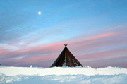
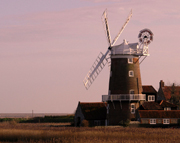
 It was late September when I boarded the train from Stockholm to Kiruna in Swedish Lapland. Not quite Christmas, although the tinsel and crackers filling the shelves of the London department stores were trying to convince me otherwise, but I was conscious of the fact that I was moving into the alleged homeland of Father Christmas. I wasn’t looking for him however, having cruelly learnt the truth behind the myth at an early age. I was rather hoping to catch sight of some of the other big beasts that still roamed this Arctic outpost of Europe.
Brazil – Rio de Janeiro
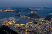 Rio de Janeiro has long exercised a magnetic lure for travellers. Escaping to Rio is a travel fantasy – unless you happen to be a Great Train Robber. The city is photogenic, passionate and exuberant. Its vibrancy is matched only by its inhabitants’ lust for life. The locals, known as “Cariocas”, are as romantic as Parisians, as animated as Italians and as nocturnal as the residents of Spain’s 24-hour cities. They personify the phrase “carpe diem”, embracing the present.
New Zealand
 Despite its size New Zealand is one of the most pristine and naturally diverse countries on earth. Unlike its mighty neighbour the highlights come thick and fast. Arriving in early June I had five weeks at my disposal. And having once experienced the masochistic concept of ‘shoestringing’, a comfortable budget was important (£20-25 per day).
During my visit I concentrated mainly on the South Island, interrupted by a 10-day foray northwards to tackle the enormous trout of Lake Taupo. I found transportation, mainly private minibus, to be economical, reliable and simple to arrange. However for enhanced viewing possibilities at least one train journey is recommended. As my budget didn’t stretch to many single rooms the dorm accommodation again was affordable and comfortable – my free BBH (Budget Backpacker Hostels) guide became quite dog-eared.
Queenstown, famed for its adrenaline-charged ‘pastimes’, enjoys more than its fair share of publicity. That said, Mother Nature has gifted New Zealand with her own breathtaking attractions to rival the highest of bungee jumps. Hiking on the glaciers Fox and Franz Josef proved strenuous and at times challenging, yet an exhilarating experience. Though proper clothing and expert guiding ensured safety at all times, hobnail boots will never look sexy.
A trip to the haunting Doubtful and Milford Sounds (Fiordland) was also very special, inclement weather conditions adding to the eerieness of the place. An organised boat trip around the Otago Peninsula rewarded me with glimpses of unfeasibly large and fluffy albatross chicks, ever-playful seals and penguins and a fascinating insight into the history of the area.
Now although ‘mixing it’ with the leviathans of Taupo took some beating, the highlight of the trip was undoubtedly encountering the immense 40 tonne sperm whales of Kaikoura. Despite the common use and often misuse of the adjective the sight of those disappearing giant flukes at such close quarters is quite simply awesome. As wildlife and wilderness invariably dictate my travelling, New Zealand’s blend of rugged natural beauty and stunning animal spectacle made this one of the best trips to date. In all a sense of adventure and a little energy are the only requirements. With minimal planning New Zealand will not disappoint.
After considerable ‘coffee-table’ inspirational research (see New Zealand Landscapes), I found the Lonely Planet Guide to New Zealand to be a good all-round travelling choice. Coupled with the now out-of-print Collins – New Zealand 1:2,000,000 folded map it was difficult to go wrong (try GiziMap of New Zealand now instead). Other excellent maps to travel around the country are: New Zealand Minimaps at 1:1,500,000 and ITMB map of New Zealand 1:1,000,000.
Browse our collection of New Zealand Maps and Guide books here >
New Zealand travel information >
Author: Chris Ray
Bolivia
 There is a certain appeal in entering a country by the backdoor. Especially if that backdoor is a wide open vast desert with nearly 6,000m-high peaks. The Bolivian border post, was just that, a post with a sign showing only two words on opposing sides – “Bolivia”, where we were going, and if you turned round you could see “Chile”. The passport stamp came only four days later in the first proper town.
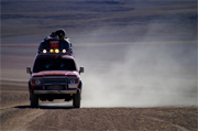
The four days unaccounted for in my passport were spent in a jeep with two Bolivians and three fellow foreign travellers in one of the driest and highest deserts on Earth. Harsh nature at its best. The guide/driver did a great impression of one my favourite scenes from the classic film “The English Patient” where a desert tour is described – endless desert stretches are negotiated without a word spoken before coming to an abrupt stop and the driver pointing out some remote feature and exclaiming with pride “Laguna Verde” (green lake) or “Arboles de Piedra” (trees of rock) – the actual line has Ralph Fiennes’ character, Count Laszlo de Almásy, say, “I once travelled with a guide, who was taking me to Faya. He didn’t speak for nine hours. At the end of it he pointed at the horizon and said, ‘Faya!’ That was a good day”. Otherwise the desert speaks for itself. The drive goes to well over 4,000m altitude, necessitating the traditional remedy for altitude sickness – coca-leaf tea. Some locals like to point out that, supposedly, even Pope John Paul II has tried it on his visit to the Andes highlands.
From here it is on to another high point – the world’s highest city in fact – called Potosi. The other attraction of Potosi, apart from superb Spanish colonial architecture, is to sink into the depths of the family-run hand-worked silver mines. You slide down rather narrow tunnels for a chat with the coca-leaf chewing miners – after all, even in the deepest tunnels you are pretty high up – some of whom are frighteningly young, like our assistant guide. One can only hope that enough of this tourism income does filter through to where it is really needed.
The world’s highest capital is La Paz (rival city Sucre is also worth visiting for its old Spanish flair and it remains the judicial capital). La Paz should not be missed while you are up here – that’s unlikely anyway as it’s a major transport hub. It is the only city that I have ever been to where the poorest part of the population has the best view – from the Altiplano plateau into a spectacular city centre valley – while the rich live right at the bottom, where you don’t lose your breath within seconds. La Paz has endless markets brimming with fruit and vegetables, livestock and souvenirs (some are brand-new, others antique and some just antique-looking). The famous witches’ market has everything you could possibly never need – from colourful herb offerings to llama foetuses.
From La Paz it is not far to the beach of Copacabana. No, the altitude is not finally getting to me. There is indeed a town sharing a name with Rio’s main beach on the shores of, you guessed it, the world’s highest lake, Titicaca, where many of the fishermen still ply their trade in traditional reed boats. Isla del Sol in the lake is one of those places people come to for a day but end up staying several more – just relax in ancient Inca surroundings and watch the sun go down.
Still having not had enough of those heights, I decided to climb an Andes 6,000-metre-er – all right, I admit, since you start so high up, this is not the world’s highest climb, but it certainly felt like it. I had met this French mountain guide who would take me up on the cheap. So cheap in fact that the crampons did not fit the boots properly on day one, and at 5,500m on the morning of day two not at all. Needless to say we did not reach the top. I console myself with the rumour that this peak is incorrectly surveyed and in fact a few metres short of that mythical 6,000 anyway. Well, that leaves me with an unfulfilled ambition, next time to be attempted with top-class equipment only!
Enough of heights, time for some lowland. The lesser-known part of Bolivia is the north-east with vast rivers eventually flowing into the Amazon, brimming with river dolphins, caimans and anacondas. Rurrenabaque has such a nice ring to it, I just had to visit. This also happens to be the perfect base for touring the jungle and pampas (lowlands). We sat many hours of the evening with torches ready to spot a tapir or jaguar, but they would not show themselves. Yet the next morning tapir prints awaited us in the river sand – another reason to come back and try again.
The best way of exploring Bolivia is with the Footprint Bolivia Handbook suitable for all budgets with great background information – or the Bolivia Lonely Planet – especially if you are looking for spots where backpackers congregate, their town maps are always pretty good in one hand, with the Nelles Bolivia/Paraguay map in the other. And I will also recommend Bradt’s Peru & Bolivia: Backpacking & Trekking (now out of print) that guided me securely on numerous other walks and the 1:50000 Alpenverein maps Cordillera Real North: Illampu and Cordillera Real South: Illimani.
Browse our collection of Bolivia Maps and Guide books here >
Author: Gerhard Buttner
England – Norfolk
 Being a mountain goat and a lover of rollercoaster rocky cliffs and coves, my brother’s choice of a farmhouse in mid-Norfolk for this year’s break did not fill me with the immediate enthusiasm my dear brother conveyed on the phone.
For the past couple of years, parents and siblings together with assorted partners and offspring have re-acquainted ourselves with the half-remembered art of the family holiday. With the experience of our ‘Somerset Sojourn’ in Easter 2000 to inform this year’s choice, the remit for Chris in his internet trawl was as follows: somewhere near-ish to London that offered comfortable, child-friendly accommodation with easy access to good pubs, walks, beaches, castles, old and interesting-to-potter-about-in towns and villages, steam railways and other fascinating curiosities with which to while away a wet and windy English June day – quite a tall order for a week’s break!
Well, I’m pleased to report that Norfolk turned out to be a pretty near perfect host for the rather exacting and wide-ranging demands of a family with such diverse interests and hopes yet still wanting to “do things together”.
Our home for the holiday was an expansive 16th-century farmhouse, lovingly restored from a roofless wreck, with flagstoned floors, ship’s timber beams, ox-sized fireplaces, an oversized kitchen table for family feasts and the all-important dishwasher. The sprawling outbuildings included a former microbrewery (now relocated to a local hostelry) plus loads of farmyard and garden space for roaming micro-people to explore. The cost compared extremely favourably with other areas of Britain and included the regular entertainment of Charlie the Cockerel who would, humorously, sound his alarm call at the thoughtful hour of two or three in the morning!
The nearby village of Hingham, with its own grumpy teashop, grand but ordinary inn and ‘Harrods of Hingham’ provided a morning’s meander and the fresh fish van direct from Lowestoft on Thursdays offered excellent value skate wings for the barbie!
Only half an hour’s drive to the east lay the attractive and ancient city of Norwich with more pre-Reformation churches than any other in Europe, the Colman’s Mustard factory and museum and the rivers Wensum and Yare offering a gateway to the Norfolk Broads. Most of the goodies are contained within the central old city and so allowed us all to wander at will but meet up easily in the cathedral grounds for a picnic and riverside stroll. I did, however, have one extra-curricular visit on my “must” list to make, just outside the inner ring road, the infamous Fat Cat boozer par excellence. This is somewhat of a mecca to real ale enthusiasts, serving 28(!) perfectly kept traditional beers, real ciders and a limited but tasty range of pub grub. We sat outside at 4.30pm on a sunny afternoon and sampled a few halves before wending our merry way marvelling at how such an enterprise could flourish tucked away on a back street corner. In these times of difficulty and closures for the traditional local, the dedication to quality service and atmosphere shone through. The take-away four-pint jug of Norfolk Nog gave a certain luminescence to the evening too!
The inevitable strains of a large family outing with small children of varying ages can often be smoothed somewhat by providing one or two focus points for the day. Wells-next-the-Sea is a traditional English seaside town. Once a busy commercial port, it offers a relaxed charm and plenty of those focal points. We all enjoyed the miniature steam train to the beach and the wide views over the sweep of Holkham Bay, famous for its birdlife, as we constructed odd-shaped sandcastles and I was dragged screaming into the icy water by my insistent three-year-old. The village green behind the winding streets of shops and Georgian/Victorian dwellings was alive with an early Summer Fayre. Throngs of revellers stood around dutifully taking the mickey out of the Morris dancers and there was a bouncy castle to entertain my daughter Bethan while the rest of us enjoyed ice creams, beers from the surrounding hostelries or both. We had considered riding the steam train to the famous remains of Walsingham Abbey but cramming too much into one day just would not have worked!
The pretty village of Castle Acre has much to recommend – two ancient priories and an even more ancient Iron Age hill fort – yes, that’s right, hill fort – with excellent views over the gently undulating landscape below.
The Ostrich Pub was shut so for refreshment we turned to an attractive little teashop with tables on the main street. I could have ordered Scone with Jam and Butter but opted for the Full Cream Tea with Earl Grey. My scone was spread with margarine. I pointed this out. “Vitalite actually. We always serve it with the Full Cream Tea”. Odd. Health conscious? I got my butter anyway.
No holiday in the area would quite be complete without a trip on the Broads. The Sutton Windmill & Broads Museum is one of those typically British, small-scale museums that one finds advertised in local Things to Do booklets. Nevertheless, it allows an entirely fascinating if somewhat under-labelled look at how the Broads were created and the everyday lives of people who worked on and near them in days gone by. You also get the chance to scale the inside of a 200ft- (60m-) high windmill via a series of wooden ladders and steps emerging on a dodgy-looking platform next to the sails. Bethan demonstrated just how much energy a three-year-old has that we grown-ups like to pretend we have by scooting up and down three times with various adult members of the family, acting as experienced climbing guide by the time I ascended the heights – “Mind that gap, Daddy!” From Wroxham we took an hour’s round trip on the large steamboat-style cruiser. There are much quieter and more independent means of travel on the Broads but the cruise suited the family fine for a taster.
And what of my love of walking I hear you ask? Sarah, Bethan and I did break off from the main pack for one more visit to the acclaimed coastline to sample a section of the Norfolk Coast Path National Trail. I had hoped to experience some East Anglian ‘Big Sky’, as an alternative to my normal desires for pointy, jagged scenery and this is where I got it. The vast expanses of sand, marsh and sea open the mind in an infinite space kind of way. The coastline is one of the most important birdlife sites in Europe and as such is protected and unspoilt in the main.
We started our jaunt from the fine Jolly Sailors pub in Brancaster Staithe. Then we headed up over a gorse-cloaked common, sweet with that wonderful coconut scent, descended with views over the Scolt Head Island Bird Reserve, past the earthworks of the Roman fort of Branodunum and along the duckboards of the marsh behind the sands of Brancaster Bay. We rounded off the afternoon sitting on the harbour wall munching happily on pots of local crayfish and Cromer crab at pleasingly low prices.
We finished our holiday with a superb lunch at the 15th-century Chequers at Thompson. Children’s meals were wolfed down before the delights of the garden, supplied with bikes, climbing frames, toy lawnmowers and real rabbits took over. The thoughtful approach to the whole family seemed to fit in with our overall experience of Norfolk.
The county offers the visitor a wealth of history, largely unspoilt villages with a touch of the timeless and a real working agricultural community alongside the leisure and tourist industry. Flat landscape, yes, but plenty of relief from stress and the mundane, and plenty to lift the spirit if not the feet.
took with me the Pathfinder Guide to Norfolk Walks and the relevant OS maps, including the map of The Broads.
- Browse our collection of maps & guides:
- > England travel guides
- > England road maps and atlases
- > Travel literature inspired by England
- > Maps and guides to Norfolk
Author: Martyn Bearfoot
Bangladesh
Not that I came only to drink their tea for free, but tea invitations are common in Bangladesh and no payment is allowed by the “guest to my country”. The staccato questions might be repetitive: “Your country?”, “Your name?”, “Your job?”, “You married?”, “Why not?”, “How many brothers and sisters?”, “You like cricket?”, but the gratitude and pleasure on the faces for friendly replies, return questions and idle chit-chat – and the free tea – is more than enough for me and for them.
Wander the markets especially beyond the big cities and all and sundry will come to shake your hand. Stop for tea and you will soon have a small crowd and many addresses of new friends. You might be shown around and be formally introduced to some of the biggest shopkeepers, their lively assistants and even to the few shy young ladies working in the more upmarket shops. Ever wanted to feel like a film star? Bangladesh is your chance!
In the capital Dhaka my day starts with some excitement. In the leafy Gulshan suburb, a group of young men wielding axes and knives run towards a smart car with a slick-looking occupant, who bizarrely steps out to meet them. Then they all stop with axes in mid-air and look at the cameraman. I am witnessing a scene from a brand-new Bengali film and the smooth dude with the flowing long hair and shades is a well-known film star. Yet some locals tell me that he is not quite as popular as his rivals from India’s Bollywood film-making fraternity.
The rest of the day I get lost in the chaotic streets and markets of the old city near the river (actually nearly everywhere in Bangladesh is near a river). I have to ask directions five times in a few hundred metres simply to find a small but beautiful mosque – ancient alleyways are hard to navigate even if your map is good. I need help! But even the rickshaw gets lost on the way back to the hotel, and after endless detouring I can eventually show him the way.
Visiting Bangladesh is less about specific highlights, than about enjoying your way to them. You have several methods – a “rickshaw” is like a large tricycle with a back seat and a poor man who speaks no English pedalling. Velo-traffic jams abound! A “baby-taxi” is the same with an engine and space to squeeze extra passengers in next to the driver. A “normal” taxi? Very rare beyond the Sheraton Hotel, Dhaka. A “minibus” is a three-quarter length big bus built for 30, usually seating 40 with 20 more standing. A “direct” bus leaves when all seats are full and then spends half the journey shouting “direct Khulna” (or wherever we are going) to fill up the aisle, and the last half of the journey disgorging passengers that bluffed their way onto the “direct” bus. Between stops the driver speeds along on roads filled by endless numbers of the previous modes of transport. Rickshaws especially are scarily overtaken as there are other, oncoming, buses.
Possibly the bus journey ends at a ferry before the town – there is always water in the way. There are numerous river-crossing ferries for cars and passengers and other boats of all shapes and sizes that follow rivers along. For three hours I enjoyed one with no seats apart from the boat’s edge. Endless buckets of water were being thrown overboard yet were constantly refilling from below…
The “rocket” is a real Bangladesh highlight. You take 24 hours – much faster than the small craft – on this Mississippi-style steamer for a roundabout journey that would take only six hours by direct bus. Yet the choice between them is easy once you have seen the comfortable cabins – in the Bangladesh context – of 1st class or even at half price 2nd class on the back deck, with the world passing by leisurely rather than with a maniac bus driver. You could try lower deck class for less comfort but more life, with live chickens and dead fish being traded on this floating bazaar.
Next destination is Chittagong – what a lovely name – for a 5am arrival. I find a hotel for a few hours’ sleep and then venture out into the hot 9am sun. An eerie silence greets me as shops are barred closed and just a few beggars stare at me from the gutter. I turn into a sidestreet where a shock awaits: flies and a pervasive stench everywhere, blood flows down the street, the crows fight over intestines, a fly-covered severed head stares at me from a pool of blood. Men with bloody shirts are brandishing long knives. Don’t worry, this is not Armageddon, only Eid-ul-Azha – the Islamic Festival of Sacrifice. All families that can afford it slaughter a cow or at least a goat for themselves and the poor. The result is a whole city covered in blood.
Time to find a more relaxed place: Cox’s Bazaar is the local favourite beach resort. Not quite as relaxed as I hoped. Thousands gather daily to enjoy the sunset with a drink of coconut or cola on the longest beach in the world. In spite of many insistent Bangladeshi requests there is no real way of capturing this proud fact adequately on my small camera.
I head off pretty soon for even less hectic waters to the southernmost tip of the country to catch the morning “ferry” – a wooden boat with a very noisy engine and too many passengers – to St Martins Island. This coral reef island is in fact the start of south-east Asia nearer to Myanmar (Burma) than Bangladesh. The only real beach stop on my journey is a bit of paradise at a relaxed pace. This is where a select few of the more adventurous urban crowd let their hair (or is it their beards?) down. I choose the local peak season by chance, making life here not quite as laid-back as the other 50 weeks of the year. But this gives me a chance to watch the local city slickers walking the beach in Nike caps and brand-name shirts, drinking tea, smuggled Myanmar beer and cheap whiskey. Then it’s off to a fish meal in one of the restaurant shacks on the beach. The wallpaper is made of calendars featuring Islamic leaders interspersed with traditionally dressed ladies with just a tiny hint of something seductive. Welcome to tourism Bangladeshi style!
The only guidebook entirely dedicated to the country is the surprisingly detailed and extensive Lonely Planet guide to Bangladesh. The Bangladesh/North-Eastern India map by Nelles at 1:1,500,000 gives a good feel for topography of this water-rich country and is detailed enough for travelling. The colourful Bangladesh map at 1:1,000,000 by The Mappa shows towns and administrative boundaries very clearly. The Mappa Dhaka city guide map rivals any of the Indian subcontinent. The Gulshan area which houses embassies and larger formal businesses is particularly clearly mapped.
Planning a trip to Bangladesh, browse our travel guides and maps here >
Author: Gerhard Buttner
Naxos & Santorini
 At the beginning of November London is not the sunniest place to be. So we thought that a trip to the Greek Islands would be a good idea, especially with the cheap direct flights to Athens available nowadays.
We were happy and confident, looking forward to some sun and warm weather on dream-like white and blue islands. We arrived in Athens and got a boat to reach Naxos. It was not warm, but not unusual for a morning in autumn. When we got to Naxos, there were about 5 of us tourists and at least 10 people offering rooms to rent. We decided for one and then went walking, looking for bicycles to hire for the next days.
We left the village and followed the coast until it got dark: it was perfect and Naxos is so dry, brown that it looks like a lunar ground! After having dinner in one of the three or four restaurants still open, we went for a walk in the lovely old town, where you can get lost in a maze of very narrow streets!
Unfortunately, it was too late in the season to rent any bike or moped and we only managed to get a car which enabled us to go around all the small and hidden places, the famous Mount Zeus or the 5m Colossus, both impressive! Two hours after we left home though, it started raining, temperatures dropped and the wind started blowing hard! We enjoyed all these excursions wearing two jumpers, waterproofs, hat and gloves! We were honestly not expecting this weather…
After a couple of days spent under the rain, we decided to make a move to Santorini: further south and eventually warmer and drier?
But, alas, same story. Too late to get bikes, we decided to explore this tiny island by foot under a brilliant sun and it was the best choice we could make – the view on top of the volcano is just superb and we were among a very small number of tourists. The following day, it began raining. We had to ask for more blankets for the room and the only reasonable activity was to lounge in a café, reading and enjoying the view over Santorini’s landscape of black lava.
We still enjoyed ourselves despite the fact it didn’t stop raining for the following two days and even worse, the bad weather worsened into a proper storm! The streets were transformed into rivers, the shutters of the hundreds of closed bars, restaurants and hotels were slamming noisily.
Then it was time for us to go back to Athens but because of the bad weather, none of the ferries were allowed to leave: so, we were prisoners of what could be a paradise but looked more like a big cold pool at the time! At the end, luckily, we got our boat to get back to the mainland on the last day and we had the pleasure to discover Athens as the previous ten days should have been: warm and sunny! So, going over there late in the autumn was a completely different experience than during summer and was closer to London than we ever would have thought!
Road Editions map of Naxos and Road Editions map of Santorini are still the best mapping available.
The Thomas Cook Greek Island Hopping guide is updated each year and includes timetables of all the ferry routes.
Browse our collection of Greece Maps and Guide books here >
Author: Jacob Genelle
Crete
 I can’t pretend that I’ve ‘done’ Crete. The island is much larger than I expected and with its rugged central terrain, and consequently slow roads, it takes a lot of time to get around. There’s also much to see. So it will be a lifetime’s study, not one holiday’s.
For this first visit we had only a week – and we also had several young children in tow. We went very early in the season, during the first week of April. The weather is variable at that time – it can be sunny and warm, but you’re taking a bigger risk then as it can also be cool and rainy. I imagine that it gets very hot in the peak of the summer. The advantage, as with anywhere off-season, is that there were far fewer people. We had beaches to ourselves, and even the innumerable tourist restaurants strung around the harbour in Hania were bearably quiet.
We were based in the Akrotiri peninsula on the northwest coast of the island, which had its own beaches and was undeveloped but was still easy to get to, less than half an hour from Hania and its airport. Hania is both a bustling, working city and a charming holiday town. Despite the countless standard tourist cafes (why do they all have to be exactly the same?), the old harbour with its lighthouse and Venetian architecture remains a relaxing spot. The covered market and the leather shops on one of the old streets near the harbour are worth a visit.
One of our best days was spent driving up into the White Mountains to the spectacular head of the Samarian Gorge. The scenery is beautiful and away from the gorge itself and the hordes who are drawn to it, I’m sure there are many rewarding walks and tours. Walking the gorge down to the south coast is one of the classic day trips of Crete, but it doesn’t open until May so we and our children were denied our chance – probably a blessing really! I’d love to spend another time meandering along the more isolated south coast of Crete, jumping from one coastal village to the next by the only means available – boat. A future visit, perhaps without the kids!
Despite the shortage of time and the distance, we determined that we couldn’t go to Crete without seeing one of the archaeological wonders of the world – the Palace of Knossos. It was a very hairy two-hour drive along the island from Hania to Iraklion and Knossos – the three-lane road is supposedly the most dangerous in Greece! Having survived the journey, I can only say that I was mildly disappointed by the palace itself. I managed only occasionally to sense the splendour of its original scale and life because as with many of these unique heritage sites the unavoidable acts of modern preservation inhibit our access and imagination. At Knossos my imagination was challenged not only by the infamous concrete reconstructions effected by Sir Arthur Evans during the original excavations, but also by the scaffolding and sheeting that prevented our seeing key parts of the site. Still, I can say I’ve been, and my six-year old daughter’s imagination was certainly captivated by the colour and drama of the pictures in the official guidebook. As I say – the beginning of a lifetime’s study.
For general tourist guidance and food and restaurant recommendations, I used the Rough Guide to Greece. It provides comprehensive coverage of the island – sadly I only used a small portion of it on this trip!
I also read Knossos: Unearthing a Legend by Alexandre Farnoux, on the background to the excavations of Knossos.
For maps, the Mairs Map of Creteat 1:150,000 scale was useful for general road navigation around the island, and the Harms Verlag Map of Western Crete at 1:100,000 provided a more detailed alternative for the local area, though there are minor discrepancies between the two!
Douglas Schatz worked at Stanfords for more than 20 years, and was the company’s managing director until April 2009. He is now pursuing several exciting ideas in the world of books and digital publishing.
- Browse our collection of maps, guides and travel literature:
- > Crete travel guides
- > Crete road maps and atlases
- > Travel literature inspired by Crete
Author: Douglas Schatz
Corfu
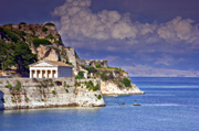 The first year we ended up in Agios Stefanos by accident: it was a last-minute holiday, late in the season. We had very little money, and somehow we ended up in this pricey resort full of luxury villas.
Our accomodation was a good 10-minute hike up the hill above the village, near the junction with the main coastal road. The trek down to the village for provisions and to eat in the evenings wasn’t ideal but we enjoyed the solitude and the superb views looking towards Albania. Every evening ‘dog’ would escort us back up the hill, until we had reached a particular spot on the road, when he would return to the village safe in the knowledge that we had been escorted off the premises.
That was ten years ago now, and we have been back twice. The village has not changed much, there are more villas, but it is still a pretty quiet place to relax, catch up on your reading and do very little.
There are numerous restaurants, the best of which was Eucalyptus, on the north side of the bay. For a treat, take the evening boat trip to Agni, a couple of bays to the south where there are three restaurants, all of a high standard.
There is a little supermarket in Agios, which does good business in selling tins of tuna to well-meaning British tourists who adopt the many cats in the village. On our last visit we ended up feeding four kittens plus mum and dad. God knows what the locals think..?
The harbour is not ideal for swimming, far better to stroll to either Avlaki, a 20-minute walk to the north, or to Kerasia, a similar distance to the south. The walk to Kerasia probably has the edge as you wind your way through olive trees, catching sight of the odd donkey. You will also pass by an estate belonging to a branch of the Rothschilds family.
From Agios you can catch the bus to Corfu town from the main coastal road, or alternatively a ferry goes from the harbour. The boat journey takes a good hour, and can get quite choppy once you are in the main channel, so take something warm. Corfu Town is well worth a visit, the shops are not great, but there is loads of history. The British left their mark, most obviously in the cricket pitch remaining on the Spianadha.
A less attractive British influence can be seen in many of the resorts of Corfu, though I understand there is a determination to promote the island as a more family, upmarket destination. I hope that Agios Stafanos isn’t promoted at all to be honest; I hope it stays the way it is now.
I’d recommend the Road Editions Map of Corfu which has topographic detail for walkers and general tourist information and the Insight Guides Flexi Map of Corfu and the Ionian Islands which includes the other Ionian islands.
The best guide is the Sunflower Guide to Corfu.
Sadly, it’s now out of print, but fans of Gerald and Lawrence Durrell who’d like to take a trip down Memory Lane should look out for old copies of In the Footsteps of Lawrence Durrell and Gerald Durrell in Corfu by Hilary Whitton Paipeti. Fortunately, you can still buy by Gerald Durrell.
Browse our collection of travel guides and maps to Corfu
Author: Andrew Steed
Walking The Pyrénées
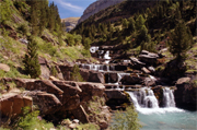 The Pyrénées, rising to almost 3,500 metres, form a natural barrier between the Iberian peninsula and France. The heavily forested valleys and sharp rocky ridges are relatively unspoilt and are certainly under less pressure than the Alps. On either side of the chain, language and culture are distinct and it’s not just French or Spanish. The Basque and Catalan languages are predominant at the western and eastern ends respectively. From a walker’s point of view the Spanish side often receives the best of the sunshine and can easily be reached from Barcelona in the east or Bilbao in the west.
Places to head for include the magnificent Ordesa National Park where various trails circumnavigate the yawning terraced canyon that gives the park its name. Further east is the Aigües Tortes National Park which, loosely translated, means Twisted Waters. A trek up to the various refugios that sit below the intimidating serrated peaks will take you along well trodden forest trails that thread their way between these delightful sparkling pools.
One of my favourite places, in part due to the good coach link from Barcelona, is the popular holiday village of Benasque in Aragón, where tiny cobbled streets wind between old stone buildings. The village is squeezed between two mountain massifs. On one side is the second highest peak Posets while on the other is the highest; Aneto at 3,440 metres.
From Benasque a good trek takes you along the route of the GR11 up the Estos valley which could possibly claim to be one of the most beautiful valleys in the Pyrénées. On either side are high 3,000-metre peaks while the deep valley floor is covered with a mixture of pine and beech forest interspersed with lush meadows of lilies. This is a good place to spot some Pyrenean wildlife including marmots, bearded vultures and the elusive pine marten.
After three to four hours walking from Benasque you can stay at the vast Estos refugio, one of the grandest, most extravagant mountain huts in the Pyrénées. Hardier souls can stay for free in one of the more traditional shepherd’s huts where you are more likely to be sleeping on a dusty floor with the mice than on a mattress with other sweaty walkers and climbers.
The Benasque area is just one part of a magnificent chain of mountains. Wherever you go the unspoilt landscape of endless forests, meadows and snowy peaks will make you want to come back and explore some more.
I recommend the Editorial Alpina Maps of the Pyrenees, Through the Spanish Pyrénées – GR11 by Cicerone Press and Trekking in the Pyrenees by Trailblazer.
Browse our collection of travel guides and maps to Pyrenees (France)
Browse our collection of travel guides and maps to Pyrenees (Spain)
Author: Jim Manthorpe