by C.J. Schüler
Hard though it may be to imagine today, until the end of the 18th century oak woodlands stretched for seven miles along the range of clay hills that runs through southeast London from Brockley to Selhurst, straddling what was the Kent-Surrey border until the Local Government Act of 1889. Since a substantial part of the wood lay in the northern reaches of the manor of Croydon, it was known for much of its history as the North Wood, or Norwood, a name it bequeathed to the South London suburb that replaced it.
I first learnt about this ancient wood while volunteering at the London Wildlife Trust Local Nature Reserve at Sydenham Hill Wood which, along with the adjoining Dulwich Wood, makes up its largest surviving remnant; other fragments survive along the A215 (Beulah Hill) to the south. As the author of three illustrated histories of cartography, I naturally turned to old maps to see what they showed of the wood and its former extent.
The first printed map to show the North Wood appears to be John Norden’s Surrey, surveyed in 1595. The map shows, on a small scale, woods and hills stretching north from Croydon towards Dulwich. Norden’s survey also provided the basis for John Speede’s more detailed Surrey, Described and Divided into Hundreds (1611/12). On both maps, the scattering of trees and hills is pictorial and impressionistic.
It is not until the 18th century that the wood appears in any detail on printed maps. The London map and globe maker John Senex’s A New Map of the County of Surrey (1729 uses hachures to indicate the hilly topography, and shows a band of woodland stretching from Knight’s Hill to ‘Pens Common’, with a lighter scattering of trees extending north via Honor Oak to Hatcham. He clearly depicts a tree-lined avenue extending south from the Green Man pub on Dulwich Common; created by the landlord John Cox to lead customers to his establishment, it is now known as Cox’s Walk, and is one of the oldest of its kind in London.
One of the most valuable sources revealing the extent of the woods at this period is the magnificent 12-sheet chart of The Country Near Ten Miles Round London, published by the Huguenot cartographer John Rocque in 1746. It records fields, farms and woodland now engulfed by the metropolis, with the North Wood stretching for more than three miles from the Green Man to Selhurst. East of Dulwich and north of Sydenham, Rocque shows a wooded hill named Oak of Arnon, today’s Honor Oak. To the south, what is now Upper Norwood is still a furze-covered waste extending from Croydon to Penge Common.
The last map to show the wood before it was swallowed by the 19th-century expansion of the metropolis is Thomas Milne’s Plan of the cities of London and Westminster, circumjacent towns and parishes &c. Surveyed between 1795 and 1799 and published in 1800, it was also the first to use modern trigonometry, enabling it to be superimposed accurately onto a modern street map.
And this is what I did, using Adobe Photoshop to relate the wood’s former extent to today’s townscape, and chart its incremental reduction to its present piecemeal pockets. As I faded one historical layer into another, it occurred to me that these sequences could be animated to create moving image of change over time. The result was a 20-minute video, which was premiered at a local environmental centre in February 2018 and toured community groups across southeast London through the spring and summer.
By this time it was clear that there was enough source material for a book. To get a more detailed view of the various parts of the wood, however, I had to track down estate plans in various archives. Unlike printed maps, these are unique, hand-drawn documents on paper or parchment that were created to denote ownership or facilitate estate management, and remained the property of the landowner. The London Metropolitan Archives hold a map made around 1600 to show the land owned by Christ’s Hospital in Brockley, including a patchwork of small woods, and another created for the Worshipful Company of Haberdashers in 1619 to denote their holdings in Hatcham, including the 4-acre Hatcham Wood.
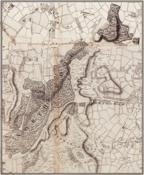
The British Library has an 18th-century copy of a map of the Manor of Beckenham originally surveyed by Nicholas Lane in 1623, showing ‘the Demesne Lands Woods Pastures Meadows and Brooks Unto the Same Pertaining’. The most important of these estate plans, however, was drawn up in 1678 by William Mar for the manager of Archbishop William Sancroft’s woods in Croydon and Lambeth (since the Norman Conquest, the manor of Croydon had been a possession of the Archbishops of Canterbury). Now in the Museum of Croydon, Mar’s plan shows a great swath of woodland extending some three miles from West Norwood to what is now Norwood Junction, and covering more than 1300 acres. Exquisitely drawn on a long sheet of parchment and – by 17th-century standards – very accurately surveyed, it shows every coppice within the woods, and denotes its acreage.
Each of these areas was felled in rotation over a ten-year cycle, by the end of which the stumps of the first had put forth a profusion of straight, strong poles that could be used for building, furniture, tool handles and to make charcoal – an industry long associated with Croydon. Both Lambeth Palace Library and Dulwich College Archive – the Dulwich Estate owned, and still owns, the northern parts of the wood – preserve extensive documentation of the management of the woods, recording which coppice was felled in which year, to whom the felling rights were sold, and how much money it raised.
It was the economic value of the woods that ensured their survival for so long; and it was the Industrial Revolution, which replaced charcoal with coal and wooden implements with iron and steel, that sealed their fate. Once woodland management ceased offer the best financial return on the land, much of the North Wood was grubbed up, first for pasture and arable and then – as the railways brought the area within commuting distance of London – for building.

The Wood that Built London: A Human History of the Great North Wood by C.J. Schüler is available to buy now for £19.99