Bologna

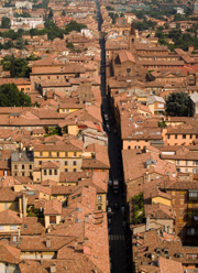
Bologna la Dotta, la Grassa, la Rossa – Bologna the Learned, the Opulent, the Red. This is how Bologna is commonly referred to and never were such nicknames better deserved.

Its thousand-year-old university (the traditional date of founding is 1088) has made it one of the most important centres for academic studies in Italy and indeed in Europe. Students come from all over Italy to study medicine, law and humanities and bring a very special atmosphere to the city. The large presence of students accounts for the numerous and formidable bookshops, the alternative scene in entertainment and the best shops to buy vinyl in Italy.

The second two nicknames come from the amazing combination of the city’s and region’s status of traditional stronghold of communism and its wealthy economy. The first Italian Socialist party was founded in Romagna and the movement, moulded by the strong pragmatism of these people, gave birth to the co-operatives. After the Second World War the Communists took over the running of the co-ops and it was a triumph: public transport, housing development and social services became models for Europe.

Bologna the Opulent also points to the strong food traditions of the region: tortellini, tagliatelle and Parmesan cheese are among its most famous world exports. It is a delight to walk along the porticoed streets of the town centre and look into the many food shops and haberdashers, drug stores you could spend hours in just browsing through the range of pasta, herbs, sauces, teas and coffees, sweets and chocolates and then just choosing one of the trattorias, unpretentious, usually family-run small restaurants, to have a nice meal.

The never-ending porticos will take you from one side to the other of the old city (ideal when it’s raining!). When I walk along them I think of Medieval scholars strolling all day through these porticos meditating on the great metaphysical questions! They would have to be careful not to be run over by cars nowadays as the pedestrian-only porticos are interrupted at intervals by streets.

There is still very little on Bologna in English. Cadogan guide to Bologna and Emilia-Romagnahas finally filled the gap as far as guides are concerned and they have done it very well – so don’t think I am recommending it because it is the only one! It has excellent coverage of the whole region as well as of Bologna itself.

The best map is the LAC street plan of Bologna. If you want to visit more of the region and Ravenna, Ferrara and Parma definitely deserve a visit if you have the time, TCI map of Emilia-Romagna is the map you need.

Browse our collection of travel guides and maps to Bologna

Author: Marina De Santis

Dublin

I have been to Dublin a few times in the last three years and I recognise that the Irish capital is a very singular city but, in a way, full of contradictions which are really difficult to explain but easy to see when you are there. Dubliners are extremely friendly people and the city enjoys a wonderful literary atmosphere and lively music all the time.

The Guinness Brewery is a must if you are visiting Dublin. Though it’s in a rough area, this symbol of the country is well worth a visit. Guided tours around the factory are available at all times and I am sure you will recognise at the end of the visit that Guinness “is good for you” with a complimentary pint. And definitely, the “black stout” tastes different up there. Slanté!

Dublin has a very intense theatrical tradition and I would advise paying a visit to one of the established companies. Not only theatre but many other cultural activities is what Dublin can offer to us. Very recommendable is the literary tour around the city following the steps of James Joyce, Oscar Wilde, Bernard Shaw and various other Irish writers.

But the best of Dublin is the city itself. Try to get lost and you will then be able to enjoy all the hidden gems in the form of little parks, obscure sculptures and those wonderful Georgian squares, still remaining almost intact. Don’t forget to go to one of the traditional pubs. The Long Hall is my favourite one without question.

I would recommend visiting Dublin twice: the first without any map or guides, just wandering around and following your instincts. For the second I would recommend the Time Out Guide for Dublin (out of print) as a first option and the Lonely Planet guide to Dublin as an alternative. The Blue Guide to Dublin is more recommendable if you are looking for more cultural background, such as history or archaeology.

Two maps: If you’re sure that it will rain (and it will), then the laminated one by Insight Guides map of Dublin will be a good option. Otherwise, Dublin Street Map by Ordnance Survey Ireland is one of my favourites.

A final recommendation – if your favourite Dubliner is as naturally inclined to pessimism as mine (a bit like that other famous Dubliner Samuel Beckett!), don’t let them ruin your visit!

Browse our collection of travel guides and maps to Dublin

Author: Julio Gil

Athens and Mainland

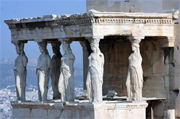
Athens. The look is definitely more LA than BC.

The high-rise concrete apartment blocks, six-lane motorways and notorious smog that sprawl above this ancient city are enough to make a Blue Guide cry. In the high summer the immense heat never relents, even through the nights. As the air temperature creeps finally into the low 30s, the concrete and tarmac respond by releasing the heat they’ve been hoarding over the last twelve hours. Mix in the traffic fumes and it seems that for Athenians smoking is just an opportunity to breathe a different flavoured air.

Visitors to Greece don’t tend to spend long in Athens. Once the Acropolis, Plaka and the National Museum have been covered, most people tend to move onto Corinth and the Peloponnese, or get a connecting ferry or flight to the islands. They miss going to an open air cinema, where light-lorn bugs splat themselves with abandon on the white teeth of movie stars. They miss the late-night pavement bars of the city’s squares, where you can join in the national sport of drinking whisky (which the Greeks are world leaders at). And if you go to the Zappeion (just off Syntagma Square), you can do all this while watching Greece’s top musicians playing live and discovering your inner primate with the pistachio nuts.

Last time we went to Greece we headed north out of the city in an Ascona that was built before I was born. Chalkidiki is a long, long drive from Athens if you don’t have air-con and if your car’s engine expires above 55mph. But the scenery on the E-75 can be varied – you can pine for the sea near Aghios Konstandinos, swelter as you pass Larissa, ‘the oven of Greece’ and cool off as you descend into the shady Valley of Tembi. Cloudy and aloof, Mount Olympus towers above you before the final leg round the plains of Thessaloniki and into the red clay and fragrant pines of Chalkidiki’s three peninsulas.

The Gulf of Kassandra has numerous sandy coves which are shunned by the locals and Greek visitors, as they prefer their beaches pebbly. The water is cool and very clear, with colourful fish that will swirl and shimmer around you if you dive deep to join them. And when you tire of playing the sphougaras (sponge-diver), eat fresh fish and watermelon for lunch and have a lazy, shady sleep. Emerge for gossip over a frappe in the late afternoon, splash back into the sea for a sunset swim, then make for the town once it’s dark. As the lights of the fishing boats head out for the night, eat, drink, then eat a sweet, and in the small hours start on the whisky. Which is one Greek habit that most of us have no difficulty in coming to terms with!

For travelling around Greece, I have always taken the latest Rough Guide to Greece as I prefer their background coverage. The Blue Guide to Greece is invaluable if you’re going to do the archaeological and historical bit seriously. Useful features include marking toll stations on the motorways (though if you’re lucky, they’ll be on strike), kilometre distance points (good for navigating without road signs) and very clear road hierarchies, even including scenic routes.

Browse our collection of map and guides:
> Athens travel guides
> Athens road maps and atlases

Author: Laura Stone

Langtang, Nepal

I have the distinct memory of standing high above Thulo Syabru, a ridge village in the Langtang region. The sun was highlighting the magnificent Langtang range we had just trekked through and it had turned into a good day, after a somewhat shaky start. Kay, Hori and I had just walked up 500m of steep mountainside, with over 600m to go.

The Langtang region is considered one of the most accessible trekking regions from Kathmandu, a mere 11 hours of a bottom-numbing bus journey away. Travel by public transport itself is an experience well worth the airfare to Nepal, from the early morning chaos of the bus station to the moment of realisation that you will be spending most of the day with 94 other passengers on a bus that has a maximum capacity of 45. There is a certain thrill to having your head out of the window, watching as the bus crawls mere millimetres from the edge of a 300m drop. It was a sobering moment when, two days after our arrival back in Kathmandu, we heard that a bus on the same journey went off the road, killing six Nepalis and injuring 14 trekkers.

Kay and I had resolved to complete a route encompassing the Rhododendron trek up the Langtang valley to Kyanjing, backtracking partway before heading up to the sacred Gosainkunda lakes and onwards into the Helambu circuit. All in 17 days, which apparently, was plenty of time. To this end we had hired a guide called Hori, partly because we felt a guide was necessary, partly to provide some input into the economy and partly because we wanted a Nepali involved in our exploration of Nepal.

The trek up the Langtang valley is one of the easier of the Nepal treks, climbing from Syabru Bensi (1,450m ) passing through various lodge villages to the next true village of Langtang (3,480m), over the space of three to four days, depending upon time restrictions and fitness. I would recommend that you take an additional day or two to experience the environment and to acclimatise to the altitude. From here it is a relatively easy trek to Kyanjin (3,950m) and beyond. The trek is magnificent, with ancient forests, steep climbs and, of course, the fabulous rhododendron flowers. Not mentioning the deer, monkeys, chuffs and mountains.

Being dependent upon trekkers for their income, various lodge villages have sprung up, catering for the hot and sweaty walker with solar showers, a basic but varied menu and genuine hospitality. Having a guide who knows the trek is definitely essential, as they can make your stays comfortable and entertaining.

The trek down the valley is easier, although we split off from the main trail, heading towards Thulo Syabru up what has to be the most mentally and physically ascent/descent/ascent stages of the whole trek. The village is a mixture of lodges and proper homes, most having an unrivalled view of the surrounding mountain ranges. From here there is another challenging ascent to Sing Gompa, through terraced fields, orchards and peaceful forests.

Sing Gompa has two main points of interest, an ancient and abandoned gompa on top of the peak, filled with beautiful Buddhist and Hindu wallpaintings, and a somewhat uninspiring cheese factory. Due to the early onset of the monsoon, the weather had become somewhat variable, and it was a wet and unnerving walk up to Laurebina Yak, assailed by an extremely heavy hailstorm and snow swiftly following our arrival.

Time and weather got the better of us, and forsaking our much anticipated visit to Gosainkunda, we headed back down to Sing Gompa. This was followed by a steep 1500m descent to the regional capital Dhunche, where we caught our bus back to Kathmandu.

Nepal is a fantastic country to visit, and to trek in. The people are almost universally friendly, often in spite of the changes wrought by tourism. Kathmandu and Bhaktapur are both highly intriguing cities, and each deserves a few days exploration. For new trekkers, the Langtang region is fairly strenuous but not overly so, requiring a decent level of fitness and some flexibility of time. It rewards with varied scenery and challenging treks. It is well set up for trekkers and although guides aren’t necessary, it is advisable for the reasons given earlier.

We took with us David Reed’s Rough Guide to Nepal, which is extremely well researched and contains some hair-raising and bloodthirsty tales from the history of this small nation. For the trek use the Langtang, Gosainkund & Helambu guide from Cicerone which, although slightly out of date, is accurate in the more important areas. We used the Himalayan Map House maps of the Langtang regions which was excellent and evoked envy in some fellow Japanese trekkers.

Browse our collection of travel guides and maps to Langtang

Author: Jose Kilbride

Kali Gandaki River, Nepal

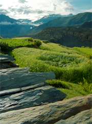
Rivers are one of our planet’s natural highways. They can also provide a jolting, roller-coaster ride through a very big bathtub, an exhilarating tussle with the forces of nature. You don’t have to be experienced, you just need a healthy appetite for adventure, don’t mind being wet all day, have a sense of humour and the desire to experience something new.

Nepal is a river runner’s paradise. Rightly famed for its trekking credentials, Nepal is also renowned for its wilderness rafting. No other country has such a choice of multi-day trips, away from the roads in magnificent mountain settings, with warm rivers, a temperate climate, exotic cultures and friendly people.

Of the trips available, a popular, medium length river descent is the one that travels the length of the Kali Gandaki river, combining exhilarating white water and spectacular scenery. This is one of the famous names of Himalayan rivers. The Kali Gandaki rises in Mustang, an enclave of Nepal that pokes into Tibet. Initially a flat river, it soon drops off the edge of the world and cuts one of the deepest gorges in the world between Dhaulagiri, height 8167m to the west and Annapurna, 8091m to the east. These two peaks are only 38km apart, providing a vertiginous gorge. Once an ancient trading route to Tibet, it is now a favourite with thrill seekers.

The river passes through an area where until fairly recently, tourists were virtually unknown. There are few villages on the riverbanks – most are located on terraces perched hundreds of metres above. Named after the Goddess Kali, the river is considered particularly holy and an auspicious place to be cremated. Consequently many of the river confluences are dotted with cremation sites and burial mounds – do not be tempted to investigate the contents of these cairns!

Most days begin in a similar fashion, usually with something hearty to eat (or to throw up later…). Gelatinous eggs are a favourite. Following a briefing on the day’s route, the river is then tackled. You are then free to paddle, raft, admire the view, see villages, eyeball rapids, spot wildlife and await the carnage! The Kali Gandaki has some 60 rapids within 60km of river, most of moderate difficulty / Class 3. (There is an accepted international standard for grading rapids, rated 1-6, based on various conditions. 1 is slow moving water with a perceptible current, 5 is challenging, technical whitewater and 6 is unsafe to run commercially.) Over the course of the trip you’ll be forced to contend with “Little Brother”, “Big Brother” and “Rafters’ Refund”, all of which are quite big enough to flip a raft. The biggest rapid on the river lies at the end of the descent. “Walk in the Dark” is a sizeable rapid, graded 4+. These should provide gut-wrenching, adrenaline fixing whitewater rafting. You’ll be twisted, turned, shaken and basically hurled all over the place. Admittedly this is not everyone’s idea of fun (so that’s just me then?), but it is undeniably a once in a lifetime experience. The sense of achievement in taming the river is tremendous. Hanging onto a piece of rope attached to a raft, whilst on spin cycle in one of the world’s largest washing machines is not the easiest thing in the world. However, you should discover that fear and determination will combine to help you develop a grip of Olympic proportions! Sodden and shaking, the adrenaline rush is enormous.

This is a classic trip, which offers the best of the Nepali rafting experience. Passing through beautiful unspoilt scenery, via dramatic gorges and wilderness you’ll encounter copious wildlife and numerous temples and palaces. Many of these buildings are now derelict, eerie shells, which look as if they belong on the set of Indiana Jones. Once full of life, they are now the redoubt of ghosts. All the while, a snow clad Annapurna looms in the background, intimidating and awe-inspiring.

For those wishing to plan an itinerary themselves, the recommended guidebooks are the Lonely Planet Nepal, and the Rough Guide to Nepal. More specialised information can be obtained from the excellent White Water Nepal, by Peter Knowles.

Himalaya Map House produce maps of the rivers Sun Kosi, Bhote Kosi & Balephi Khola and Trisuli but an overview of the whole country can prove very useful, especially if it comes in the quality of the Nelles map of Nepal.

Browse our collection of maps and guides:
> Nepal travel guides
> Nepal road maps and atlases

Author: Alex Stewart

The Mapping of the Indian Continent

George EverestThe mapping of India is a tale that touches all strands of culture, history, science and politics ensuring that one cannot help but be fascinated. The feats and determination of the surveyors astounded me when I first undertook the study of cartography and their effort is entwined with our need for understanding our planet as well as the desire for ownership.

The first known map of the Indian subcontinent was created as early as the third century BC. Drawn by Eratosthenes the map was based upon a mix of information from Alexander’s invasion, hearsay and myth. Little wonder that this was improved upon by the great Ptolemy, in the second century AD, who recognised the existence of the Himalayas and the Ganges and, incredibly, whose map was used until the 16th-17th century. Subsequent maps were produced through measured routes and astronomical calculations, but it was only when Arthur Wellesley (later to become the Duke of Wellington) destroyed the Tipu Sultan and took control of Mysore for the East India Company that accurate land surveys of India were undertaken. The resulting maps were to be used as tools for military intelligence as well as establishing effective trade routes and centres for imperial commerce

Wellesley had brought to India Captain William Lambton, who was to produce one of the most extraordinary feats of surveying, the creation of the Great Arc of India. The Great Arc was the longest measurement of the Earth’s surface ever undertaken, one of 1,600 miles, with the dual purpose of mapping India and measuring the curvature of the Earth.

Lambton’s extraordinary skills were honed in America. He was an ensign in the 33rd Regiment of Foot when they were called to fight in the American War of Independence. Taken prisoner almost immediately, he was to survey and delineate the boundary between British Canada and the USA. His surveying techniques were inspired by William Roy of the Ordnance Survey and the Cassinis in France.

The survey, begun in 1800, was based upon triangulation. In simplistic terms, a baseline is accurately measured and the angles of the triangle are calculated by sighting a point with a theodolite. Then one side of the calculated measurements of the first triangle is used as the base line for the next and so on. The end result is a web of triangles, the size of which can vary depending on where one can sight to. This, however, is complicated by the fact that the earth is uneven and round; angles of any triangle on this surface do not add to 180 degrees so spherical excess has to be calculated and removed. To make things worse the earth is not truly round, shaped more like a grapefruit (or more accurately, an oblate spheroid). The aim of Lambton’s Great Arc was to enable the accurate measurement of the earth and the accurate calculation of the spherical excess. His Arc was created as a series of triangles that progressively moved towards the Himalayas.

Lambton never saw the conclusion of his master plan, the Arc took nearly fifty years and many lives as the Arc progressed through malarial and typhoid ridden territory. Lambton died in central India in 1821 (or 1823 according to some sources), halfway through his Arc, so the Arc was to be completed by his Welsh assistant, the man who was to give his name to the highest point on Earth, George Everest.

The tale of Everest’s obsession with detail and mathematical accuracy as well as Lambton’s undertaking of the Great Arc is documented in the book of the same title, The Great Arc by John Keay. The book provides the background to the two extraordinary men as well as the hardship they and their surveyors endured to achieve this incredible feat. For anyone with an interest in surveying, cartographic achievement and monumental effort, the book is an essential read. The book also documents the impact cultural differences had upon the survey as well as some of the more spurious scientific ideas of the 19th century.

Unfortunately, Everest must turn in his grave every time the mountain’s name is mentioned. According to Keay, his name was pronounced as Eve-rest, not Ever-est, and he would have passionately disliked any mispronunciation of his family name.

Author: Donna Wright

Reykjavik

I can’t recall London’s weather conditions in February with any greater clarity than I could describe my prevailing mental state, but suffice it to say things were cold, damp and grey as usual and thus not very interesting – and the weather was little better. However, I had a solution.

My perverse logic told me that if I were to go somewhere where the weather was more severe, conditions might not seem so uncomfortable back here by comparison and I would experience some more exciting weather into the bargain. Of course a few days camping atop the Brecon Beacons with a leaking tent could achieve this objective, but a man’s got to know his limitations. After some consideration it seemed more sensible to opt for the North Atlantic.

I had always wanted to go to Iceland so I made some enquiries. I learned from the Iceland Tourist Board that there had been relatively little snow over the winter to the extent that the snow-mobile rental business was feeling a bit left out in the cold, so to speak. Furthermore, a contact in Reykjavik told me that it was warmer than usual for the time of year, at a sweaty 1ºC. Not as cold as I had imagined, but I assumed that she hadn’t included the all-important wind-chill factor. I decided upon a short break in Reykjavik, once a deal had been found which wouldn’t haemorrhage my bank account.

We touched down at Keflavik airport under a familiar looking grey sky. There wasn’t much snow around but something told me it wouldn’t remain so. As the shuttle bus to Reykjavik pulled away from the airport’s wacky sculptures and proceeded along the straight road north-east through the stark lava fields of the Reykjanes Peninsula, I was comforted by something I had read about Iceland’s capricious weather. It goes something like – ‘if you don’t like the weather now, give it five minutes’.

About 30 miles later, we were installed in the hotel. The room had a splendid north-facing view across a building site, some suburbs and the sea. The twinkling lights of the town of Akranes about 13 miles away were beginning to illuminate as the evening approached and almost all of the 2,982ft high Mount Esja was in view to the north-east. The suicide-proof window wouldn’t open very far but if I squeezed my head far enough out through the gap into the chilly breeze and looked west down the main road I could just see the spire of the Hallgrímskirkja and the town centre, just under a mile away.

An initial excursion into town soon followed. The town centre and Laugavegur, the main shopping street which leads to it, were quiet, with just restaurants, bars and a couple of supermarkets still open. At £5 a pint, pubs were unfortunately off the agenda and anyway I’d visited the duty-free shop earlier, so the alcohol issue had been taken care of.

The town looked very pretty with white fairy lights illuminating the trees in the streets and Austurvöllur, the square in front of the parliament building. I don’t know if these were maintained throughout the year, or were just the remnants of Christmas festivities, but it felt a million miles from tacky London. We wandered around some of the local landmarks for a while and noted the popularity of what appeared to be stuffed puffins in curio shops, and then it happened – snow, loads of it, driving near-horizontally through the streets, getting in my face, getting in my pockets. This was what I had come here for – it just doesn’t happen in London anymore.

Turning a corner we found a hot-dog vendor and had our first taste of Icelandic fast food. My experience of the local cuisine wasn’t to get much more sophisticated, frankly, but it suited the moment. Intent on not forking out too much for food, I had brought with me biscuits, pistachio nuts, peanuts, vodka and a firm intention to pig-out at the hotel’s breakfast buffet. It had everything one needed to keep the carbohydrates and caffeine level up. No putrefied shark meat or puffin, but plenty of pickled herring which, once tried, didn’t form a significant part of my intake, it has to be said. We supplemented this diet by making sandwiches with various cheesy and fishy sandwich spreads from the supermarket. I’m not sure how long we could maintain this thriftiness as we were only there for four days, but impoverished low-budget travellers take note – you don’t have to spend an obscene amount of cash to maintain your basic metabolism.

From the hotel room, when I wasn’t distracted by the telly (a disappointing selection comprising CNN, MTV, porn etc.) there was a perfect view of the snowstorm and its limited consequences for traffic on the main road below, compared with the chaos we’re used to here. Nobody appeared to slow down significantly, but then the roads were being cleared and much of the traffic seemed to consist of off-road vehicles. The scene outside was complemented by the constant howl of wind resonating through the ventilation system in the bathroom.

The following morning brought no change in the weather and as the dawn progressed we could see the various landmarks appearing and disappearing as banks of snow-bearing, low cloud swept in from the ocean. The day’s excursion got off to a false start when I had to come back in and put on my thermal long-johns. Once the situation was rectified, progress could be made in comfort.

Struggling along Sæbraut, the main road along the bay towards the harbour, it was hard work trying to stay upright in the face of the gale. The locals had a mountain goat-like tenacity which we outsiders couldn’t match, and seemed to be unperturbed by comparison. Didn’t matter though – it was fun and it wasn’t going to end quickly, unless I were to drop my guard and let the wind fling me over the sea wall or across the road into the path of a snow-plough. The only problem was freezing fingers within a few minutes of taking off my gloves to use a camera. The general temperature was 0ºC and the wind was near gale-force from the west, so with that wind-chill factor it worked out at something like a buttock-clenching -12ºC.

The high point of the day was going up to the 245ft-high viewing level in the spire of the Hallgrímskirkja, the distinctive church on a hill overlooking the city centre. Having struggled across its forecourt to the main entrance, we found it closed due to the weather and we were directed to the entrance at the opposite end. This took us through a room which appeared to be hosting a keep-fit class for some of the local senior citizens, but they weren’t bothered by the intrusion. A lift took us up to the viewing level just below the belfry. It was open to the elements and produced an almost unbearable, deafening wind-tunnel effect. The view over the city was great but I wasn’t too confident about how steady my photos would be. The old folks were still there when we left but had settled down to something less strenuous, presumably to conserve energy for their inescapable journey home.

I could go on, but space doesn’t permit it. Anyway, I think you get the picture. By the way, I took the Insight Guide to Iceland which was informative and adequate for a short stay. I took no street map as nothing was published at the time. Now we have the Iceland Insight FlexiMap which includes a Reykjavik street plan and is waterproof, which is appropriate given the conditions you may encounter. Also interesting for portraying the bigger picture is South-West Iceland map published by Landmælingar Islands, the Icelandic survey organisation. It is centred on Reykjavik and includes all of the Reykjanes Peninsula, and extends east to the highlands through which many organised excursions pass. In the town hall at Reykjavik there is an enormous raised relief map of Iceland on display and well worth a look. It’s a one-off, so don’t ask if we can get one.

Browse our collection of maps, guides and travel literature:
> Iceland travel guides
> Iceland road maps and atlases

Author: Chris English

The Bill Bryson Interview

Bill Bryson
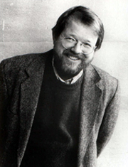
As a highlight of Stanfords’ annual Travel Lecture season, Bill Bryson visited London to talk about his writing life and latest travels in front of 2,500 fans. We are delighted to present a full transcript of his live interview, with Douglas Schatz firing the questions.

Introduction

As the cliché goes, of course, our guest needs no introduction, but for the benefit of anyone who has just arrived from another planet and stumbled into the hall here tonight, I can confirm for the record that our speaker, Bill Bryson, is this planet’s favourite travel writer.

It is not only the staggering sales of his six travel books that have earned him this eminence, but also the fact that his books are so accessible, perceptive and most of all, of course, wondrously funny. He is to travel books what Delia Smith is to cookery, or J K Rowling to children’s books. In other words, he is the best.

Continue reading The Bill Bryson Interview

Ladakh, India

Ladakh, also described as Little Tibet, is an expanse of high, arid otherworldly mountains, devoid of vegetation, made of infinite shifting shades of brilliant brown and grey, dotted with the most colourfully dressed people I’ve ever seen.

Only two roads penetrate the region, each only open for a few months each year. These are some of the most arduous and demanding in the Himalayas, both taking at least two days by bus. From Srinigar the road passes ancient gompas (monasteries) and relics dating back to the first century BC, offering majestic views over the main Himalaya range and the Indus Gorge – that is if you can keep your eyes off the bits of road dislodged by the bus wheels tumbling down sheer thousand foot drops.

From Manali you cross one of the highest road passes in the world, the Taglung La Pass, just under 5,300m. I descended into the upper Indus valley via this route. A local woman next to me started moaning quietly and vomited. She passed out, but thankfully reawoke later. It was a ‘white-out’ outside, not from blizzard but from vertical light on a seemingly endless, near vertical, perfect incline. At one stop I went for a ‘walk’ in the snow up the mountain side. All sense of distance dissolved and suddenly I was floating in a white void. I returned to the bus, eager to be free to roam once we arrive.

Leh is the capital of Ladakh, last main stop before the actual highest road in the world, the Kardung La (5,600m), and Chinese occupied Tibet. It shelters in one of the Indus’ tributaries, the Zanskar, looking out into the immense Indus valley and across it south to the Stok mountain range. It is impossible to convey the mind-expanding sensation of passing through this landscape. Sitting in a café in Leh, a peak (over 6,000m high and 60km away) appears to be just the other side of the fence. The air is so clear that unfeasible detail is visible and the size is so vast that normal concepts of proportion and distance are just not up to the job. Things get a bit more real when the piece of mountain you’ve walked towards for four hours has stubbornly refused to get any nearer.

Preparation is minimal: hire a tough tent and sleeping bag, buy a Primus stove and a map, and get a brolly to wear on the rucksack (cheaper and safer than sun cream). Socks double as gloves at night, and I found a pair of old army issue sun goggles for few rupees. Laughable, but this was serious budget trekking. Later, on the mountains we met a distraught couple whose state of the art Goretex tops had worn through and whose bivouac bags had ripped and leaked.

It was late afternoon when we arrived at the first stream crossing. By this time it was flowing with melted glacial ice, and what was a narrow stream was now bordering on rapids. (This was to be recurring feature, proving that enjoying a lay in when in the mountains can make things difficult later on in the day – but I’ve been told a number of bridges have recently been built to ease this problem).

The only way to cross is to leap from a large rock, hurling the sacks. They both made it but the primus stove, cunningly strapped to the outside of my sack, suffered a fatal blow. No problem, we’d use local methods and cook using wood. But by the time the sun set, we had found three twigs between us. This is the rain shadow of the Himalayas. Any vegetation that could be burnt had already been snapped up by teams of roaming Khampa (nomadic) women, to be frugally used at home. Fortunately we met some incredibly friendly, colourful sherpas, who shared some strange alcohol with us whilst teaching us the skills of cooking a whole meal with three twigs and selected donkey dung. Their methods worked perfectly, and the animal skins they wrapped up in under the stars seemed to keep them warmer than our western made tents and sleeping bags.

Fast-forward a few days and a few thousand feet, and we’d reached the highest pass of the route, one of many around 5,000m. With only a dusting of icy snow, I had an unstoppable urge to reach a peak well above the snow line, a seemingly reachable 1,000- to 1,500-foot more. Touching the ceaseless arid expanse was the incongruous blue green snout of a glacier, dragged out from the snow by gravity, to melt in the dust. The easiest route to the snow line appeared up the edge of this frozen serpent, so I started the climb. Every ten minutes or so there was an eerie deep groan, as the pressures within the ice tore at its insides. Then, much higher pitched glassy explosions, as immense chunks of ice shattered into thousands of shards, which then rained down on the rock below. The movement of this beast was audible if not visible, and whilst pouring over a ledge, colossal, four-storey chunks of ice had been thrown up at improbable angles, frozen in time as well as temperature. They were amazingly suspended directly overhead, and gravity formed a straight line between them and me – time to find another route.

A different approach further up the path met with different problems. Within 20 minutes of leaving the trail, I found myself consumed by waves of tiredness, but with such breathtaking scenery I was compelled to continue. However the waves got progressively greater until I was having to count my footsteps to maintain my concentration, and then sit down to rest. Ignoring all the signs I continued at this pace – 20 steps then resting. Once my progress became ridiculously slow I decided to return down. Not so easy though. My stops had become involuntary, and the urge to sleep was overwhelming. Only with every ounce of will power did I stay awake and now with hindsight I realise how important it was that I did.

Ladakh heaps unforgettable experience on you, whether you’re just absorbing the views or clinging to precipitous mountain faces. Next day, as evening arrived, we stumbled upon some men working on an exquisite stupa. They appeared to have finished for the day, and on seeing us invited us into a nearby hut. There they gave us a drink consisting of fermenting millet in large mugs, with hot water poured on top. The resulting warm alcoholic liquid is drawn up from the bottom with a straw and is a welcome cousin of beer. It was warming to see that even in remote cultures in the most distant lands, after a hard days work on a building site, the workers liked nothing more than few pints.

There are numerous treks you can safely conduct yourself. It is actually hard to get lost in such a vast landscape, as, without ropes, you can only travel in one direction. If it is culture and not trekking you are interested in, the stunning Gelukpa monastery at Thiske, the masked Tantric festivals of Hemis, the ‘fakir’-like behaviour of the monks at Matho Gompa, the wolf-pits higher up in the valley, all with this vast lunar backdrop, simply enthrall.

For an in-depth excellent trekking guide try Trailblazers guide to Trekking in Ladakh. As for maps, Leomann map series sheet 3 – Leh, Zanskar, and Nubra Valley is the best option.

Browse our collection of maps and guides:
> Indian Himalaya travel guides
> Indian Himalaya road maps and atlases

Author: Alex Webb

France – Côte d'Opale

Cote d'Opale
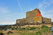
With our hemisphere spinning inexorably into winter, it was time to ‘fill the boots’. Having overspent the month already, a cheap local destination seemed prudent, with a chance to test a friend’s theory that often what is searched for far away can be found in the local. Thus the much unpublicised two-day coastal flanner from Calais to Bolougne seemed ideal.

Along the Cote d’Opale, Opal Coast, stretches the GR du Littoral, covering a stunning stretch of coast moving from expansive, flat, tidal washes edged with dunes to high, sheer cliffs, under constant attack from the south-westerlys. These winds carry with them the strange weather conditions forming the Opal in the name, a beautiful opalescent light which dissolves the horizon, merging the sea and sky. The tidal flats are the playgrounds for the region’s obsession with sand yachting, whilst the cliffs form two promontories, Cap Griz Nez and Cap Blanc Nez (the first ascent of the 2001 Tour de France) between which is some of the best windsurfing conditions in this part of Europe (sandy, no groynes, regular winds and tough waves around the two points, though with some strong currents – damn, I didn’t have my board on me!).

Punctuating the coastline are the once menacingly poised blockhausers (concrete bunkers), some the size of the Dutch barns nearby. Now their hulking smooth concrete bodies slide gracefully down the dunes, like some crashed otherworldly craft. One at Audinghemn could launch its shells at England, whilst another inland at Eperlecques, topping a vast subterranean network was to breed V2s and spit them at Britain, thankfully halted before completion.

The coast out of Calais has some cute enclaves of stylish house sized beach-huts fronting the expanse of dunes, which gradually rise into the cliffs. Sangatte is your last chance to decide whether to make it under the cliffs past Cap Blanc Nez (2.5km) before the tide gets you, or to take the high path. Having ascended Cap Blanc-Nez the Dover cliffs, lit from the south, seem almost reachable by lilo while the Flemish fields stretch eastwards. After this places to stop are beachy: Wissant (also a good base for windsurfing) and Audresselles, avoiding the lifeless Ambleteuse. Just before the cranes of Boulogne materialise is Wimeroux, whose northern beach is covered in large, disc-shaped rocks that must be scaled if the tide is rising.

For maps, the superbly accurate IGN TOP25 map of Calais 2103ET and IGN TOP25 Boulogne-sur-Mer map 2104ET are indispensable, whilst the Michelin Green Guide to Northern France & the Paris Region covers this region thoroughly.

Browse our collection of maps & guides:
> France travel guides
> France road maps and atlases
> Travel literature inspired by France

Author: Alex Webb