 US travel enthusiast James Hetherington describes his five favourite Grand Canyon hikes.
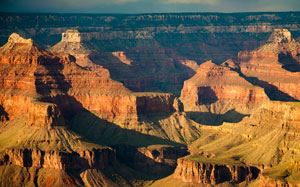
The Grand Canyon: the product of hundreds of millions of years of geological transformations, culminating in the creation of one of the greatest natural wonders in the world (and one visited by five million people per year). Few people are aware of the sheer size of its national park, which occupies an area more than 434 kilometres long; approximately twice the length of Wales. Here, we take a look at some of the national park’s most tantalising hiking routes, from those suitable for beginners to challenges suited to the more serious hiker:
1. Hermit Trail
The Hermit Trail was founded by Louis D Boucher, a local resident who created the Boucher Trail and was an important member of the South Rim community. This route begins and finishes at the Hermit Trailhead, situated at an elevation of 2,024 metres, before descending rapidly to a height of 884 metres at Hermit Creek. Here, visitors can witness some of the finest uninterrupted sunset views in the entire park, though during the summer hikers may need to arrive earlier to secure the best viewing spots.
2. Rim Trail
The Rim Trail is a relatively straightforward route and features an altitude variation of just 200 feet. This makes it much more suitable for winter hiking, when steeper routes are largely inaccessible. Much of the trail contains modern paving and visitors can enjoy superb vistas of the inner canyon. However, during thunderstorms the area is highly exposed and prospective visitors should consider checking the local weather forecast before embarking on this route.
3. Grandview Trail
Created by copper miner Peter Berry, hikers along the Grandview Trail are greeted by the sight of the Supai Group, which accompanies them to Horseshoe Mesa. Underneath Horseshoe Mesa is the Cave of the Domes, which is noted for its striking limestone formations, many of which have been developing for thousands of years. The trail is one of the steepest hikes in the park and is only recommended for experienced hikers.
4. North Kaibab Trail
One of the most rigorous hiking routes, the North Kaibab Trail is 45 kilometres in length and descends almost 1,800 metres. The journey begins near the narrow waterfall of Roaring Springs and finishes at the Colorado River. For less experienced hikers, however, the simple four-mile return trip to the Supai Tunnel or the 1.5-mile return trip to the Coconino Overlook should be more than enough to capture the intense beauty of this trail.
5. Bright Angel Point Trail
This is one of the easiest trips and is perfect for capturing the sunrise and the sunset over the canyon. The route can be completed in as little as 10 to 20 minutes and starts at a log shelter before continuing for approximately 0.8 kilometres. Along this narrow trail, hikers can observe the Kaibab limestone and enjoy fabulous panoramic views that extend as far as the towering San Francisco Peaks to the north of Flagstaff.
 The Grand Canyon: A desert landscape with undiscovered gems
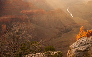
It would take years, if not decades, for even the most ambitious explorer to lay footsteps on every trail in the Grand Canyon National Park. Indeed, this vast wilderness hosts many more walking trails, some of which have remained largely unchanged for hundreds of years.
> Want to find out more about the Grand Canyon? Discover our collection of Grand Canyon maps and travel guides.