 Utah is an amazing destination for people who like outdoor fun. But my recent trip there started in the urban jungle of the metropolitan Los Angeles. It is just much cheaper to fly there than anywhere in Utah itself.
It was all great until I left the car hire depot. The first moments of driving on the notorious LA freeway network can be intimidating, frightening but also exciting in the same moment. It takes some time to get used to drivers completely ignoring rules, indicators or speed limits. And all this on roads with 12 or more lanes of bumper-to-bumper cars doing well over 80mph and overtaking on both sides, changing lanes just inches in front of you and so on. The only way to survive is to behave in the same way; it comes easier than you can imagine. It was the Friday before the long memorial weekend, when half of the Americans travel somewhere, so the situation was particularly bad.
Fortunately my friend from LA, using a highlighter pen and a Benchmark atlas of California(which we sell), showed me a route which avoided the main highways, and goes through the local desert roads instead. Thanks to him, in just a few hours I was able to move from the densely populated metropolis to the open desert landscapes. In one-and-a-half days I blasted through deserted parts of California, Nevada, some short stretch of Arizona and arrived to southern Utah.
And what a great state it is.
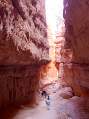
 I started exploring it from the Zion National Park. The main attraction there is a canyon which the river Virgin carved through the multicoloured sandstone formations. I won’t be describing all the geological details (first because it is boring for most people and second because I forgot the details of my geology classes a long time ago). But even if you can’t tell the difference between sandstone and granite, you will be stunned but all the wonders of Zion. There are plenty of good hikes for everyone. For the lazy or not very healthy ones I recommend Riverside Walk which is no more demanding than a stroll in Hyde Park but offers close contact with a narrow section of the canyon. Unfortunately it also offers close contact with hordes of tourists. Fortunately there are some short but steep hikes leading away from the crowds; for example Weeping Rock Trail. But if you are fit and don’t have agoraphobia I strongly recommend the Angels Landing Trail. It is a steep, strenuous walk where you gain 1,500 feet of elevation in the distance of 2.5 miles. First you fight many switchbacks which you think will never end and then you arrive to the best part of the trail. The last few hundred feet of it are formed by chains, steps cut into rocks, and ridges as narrow as three feet. Views from the top are well worth all the efforts, but remember to take plenty of water (not available anywhere on the trail), sunscreen and start early. Zion NP is quite low and can get unbearably hot during the midday.
The cheapest form of accommodation is camping, which also allows you the closest contact with nature. Try to get your spot early as park campgrounds fill up quickly and you might end up like me, camping somewhere on public lands out of the park, which is OK except for the fact that there are no facilities.
Zion NP is one of the most popular National Parks, and because it is also one of the smaller ones, it can get very crowded. Fortunately it is also he only park in the US which bans individual cars (at least in the summer season) and offers public transport instead. Anyway, try to avoid weekends.
 The next great national park of my trip was Bryce Canyon. It is just a short (about two hours) drive from Zion NP but the landscape there is completely different. Bryce lies at 8,000-9,000 feet above sea level, which places it over 3,000ft higher than Zion, and makes it a much cooler park, covered largely by pine forests. As in Zion, the main attractions of Bryce Canyon NP are geological formations. These are called hoodoos, types of rock pinnacles formed by specific erosion processes. Again, lets skip detailed geology classes (you know, my memory). They form landscapes which look like they’re from fairy-tales. It is the most impressive at sunrise or sunset when long shadows and warm sunlight form a magical atmosphere. I recommend hiking down to the formations early in the morning using combined Navajo and Queen’s Garden loops. They bring you close to hoodoos, slot canyons (some of them just a few feet wide but over 100 feet deep) and other less known wonders. Just beware that even if the trail is not difficult (with a combined ascent and descent of 800 feet), due to the elevation you will get tired much quicker than you think – and hope. Morning light is also great to take pictures.
In the afternoon you can drive the rim drive stopping at the various viewpoints to admire the whole park. Unfortunately camping in Bryce means freezing cold at night. It was one of the reasons I got up early enough to see sunrise – it was simply too cold to sleep.
West of Bryce Canyon is one of the best drives of my life. It is Utah Hwy 12 which is designated a US Scenic Byway. For well over 100 miles, the road turns and twists through the amazing landscape. It is a geology wonder, continuously unfolding in front of your car. I wanted to stop every few hundred yards to take yet another picture but eventually the batteries in my camera ran flat which let me just simply enjoy the drive. In my opinion this road is as good as the famous Pacific Coast Highway in California.
But getting to my next destination also involved driving some pretty boring, flat, straight roads and staring at desolated landscapes, sometimes for hours. Thank God for the satellite radio. It was getting dark and I really wanted to get to Green River to find a cheap motel (after few days of camping, including the freezing night at Bryce, I really deserved a normal bed). Fortunately I could easily drive 90-100mph as the road looked like a 40-mile long runway, completely straight, wide and empty. Did I mention I love driving?
Green River would be absolutely not worth writing about. Just a cluster of gas stations, motels and fast food restaurants with the population scattered around. A community which survives thanks to interstate highway, but somehow I like this sort of place (for a short time, of course), where everyone and everything is on the way to somewhere else. It is something you can’t find in Europe; it is part of the American road culture. So I mentioned it anyway.
 But let’s move on. The following day I arrived at Arches. It is another small and compact national park but also full of geological wonders. The main attractions here are the rock arches formed by complicated erosion processes in Navajo sandstone. What strikes you first is how red everything is. The rocks are red, the sand is red, the bit of soil you can find there is red. Even the tarmac on the park road is red. It contrasts with a few green patches of vegetation; this is a real desert park. Once I got out of the air-conditioned car I felt even my eyeballs drying, so don’t forget to carry plenty of water.
The most popular hike in Arches NP is to the famous and picturesque Delicate Arch. It is just 1.5 miles long with less than 500 feet elevation gain, but don’t underestimate it. Most of it goes along slippery slick rock, there is no shade on the way, no water, and it gets incredibly hot, even hotter than in Zion. The arch itself is amazing, many people have seen it in pictures or on TV, but nothing compares to the real thing. I got there an hour or so before the sunset and many people were waiting already with anticipation, like before an important sport event. Clouds obscured the sunset but the changing light made the time I spent there a really magical experience. There are of course other walks in the park; a few good ones are around the Devils Garden area. They let people explore features other than the arches (rock spines, ribs, enormous boulders; in one word: rocky labyrinth).
There is just one small campground in Arches itself but there are plenty of camping opportunities on the BLM lands alongside Utah Hwy 128 which follows the Colorado river just outside the park boundaries. Most of them don’t have showers but they do have pit toilets. If someone prefers the luxuries of a standard bed, the town of Moab (also just a few miles outside the park) offers plenty of options. It is a small, attractive, friendly, and a bit funky community dominated by young people in search of outdoor fun (mostly mountain biking). Not a typical small Utah town. It is a stark contrast with Green River.
Close to Arches NP and Moab lays Canyonlands NP. This is an absolutely enormous park, made of three districts separated by canyons at the confluence of the Green and Colorado rivers. To move from one district to another you have to drive hundreds of miles. I visited just a small section of the park but even that involved long driving and great vistas. There are a few short trails, but it is rather a destination for serious explorers who have much more time than I had. Anyway, it is worth visiting just to peep into the enormous labyrinth of canyons from a few viewpoints alongside the park roads. It is also much, much emptier than any of the parks I visited before.

From reading this quite boring article you might think Utah is all about deserts. Nothing could be more wrong. Most Europeans don’t realise how big and diverse most of the states are. After all, Utah is larger than Britain. I realised it when, after a few days of exploring southern Utah’s geological paradise, I decided to go north and visit Salt Lake City (it was on the way to Wyoming anyway). It was another long but spectacular drive. Gradually the landscape gets less desert-like and more alpine scenery starts dominating. Just before Salt Lake City the road navigates mountain passes almost like in Switzerland. One thing however stays constant: the low density of population.
It means that arriving to SLC feels like coming to a great metropolis, which is of course wrong. It is a mid-size US city with a pleasant downtown and great location at the foothills of the Wasatch Range. It is nice indeed (especially after one week in the deserts) but you can’t really call it a metropolis.
I skipped the greatest attraction in the city, the Temple Square, the heart of Mormon religion, and went to visit the State Capitol building instead. It has free admission and is quite interesting. Some of the paintings and sculptures inside somehow are similar to the socrealistic art of the former eastern bloc. Look at some of the titles: “Immigration & Settlement” or “Science & Technology”, not exactly how Van Gogh or Monet would call their works. Fits more into the Kremlin collection doesn’t it? And how about marble and granite toilets? How cool is that? You can visit the building pretty much on your own, no one even checks your bags. Or you can join a tour led by nice retired volunteers. How about buying a Utah fridge magnet from the capitol store? Only in America.
But it was time for me to move on. Wyoming was waiting. Another state larger than life. I’ll write about it next time…
For more details I suggest the Moon Guide to Utahor Moon Guide to Zion and Bryce(which includes Arches and Canyonlands National Parks as well).
For navigation I used the Utah Recreational & Road Atlas by Benchmarkand walking maps of the national parks (Zion, Bryce, Archesand Canyonlands) published by National Geographic.
Author: Gregor Swiderek
- Browse our collection of maps, guides and travel literature:
- > USA travel guides
- > USA road maps and atlases
- > Travel literature inspired by the USA