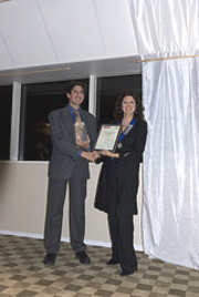
The winner of the Stanfords Award for Printed Mapping was announced at this year’s British Cartographic Society’s (BCS) symposium, and our own shop floor manager Stephen Edwards was there to present our awards certificates.
 The Stanfords Award for Printed Mapping was created to encourage any printed products to be entered, from coffee-table atlases to maps featured in leaflets or topical articles. Past entries have ranged from world map wallpaper to artistic interpretations.
Stephen said, “I really enjoyed visiting the BCS symposium and awarding the prizes. The maps entered were all of a very high standard and between them, the five winning entrants represented a diverse range of printed mapping.”
The judges decided as well as the winner, two highly commended and two commended certificates should be presented.
The top prize went to Helen Stirling for Moray Health Walks. Produced as part of a health initiative developed by Moray Council and NHS Grampian, this set of maps was described by the judges as “clear, well-designed and executed…ideal for the target non-map user.”
They added, “The small symbol set uses symbols that are easy to understand and should reduce ‘map phobia’, the choice of colours and the limited colour palette adds to the overall clarity. It was particularly interesting to see that as each walking map stands on its own they can be downloaded individually from the council website.” Ms Stirling was unable to attend, so BCS president Mary Spence received on her behalf.
High commendation went to Collins Geo 2009 Fold-out Road Atlas of Britain. The judges said, “The compact format, clear presentation, comprehensive detail and well determined name placement combined with a good balance of colours meant that this entry was a firm favourite. A very useful and usable product.” The other highly commended entry was Global Mapping – The Dynamic World. The judges said, “This is an educational world map depicting the natural phenomena that shape our planet. We liked the currency and relevance of the map and found it informative and the overall appearance and use of colour is pleasing to the eye.”
Commendation went to Collins Geo – The Times Comprehensive Atlas of the World, and the judging panel said, “This atlas continues to show the way in cartographic excellence.” The other commended award went to A&Z Cartography – Fishing Map of the Rackeve Branch of the Danube. The judges felt it used a good balance of colours and would provide the Fishing Association members with a product that would be useful to the experienced fisherman whilst providing excellent background detail for the ‘fishing-tourist’.
See how the Stanfords map award began
The British Cartographic Society website: British Cartographic Society