 There’s definitely something strange about the river country along the Severn Estuary. Whether it’s the influence of the mile-wide tideway, the big overarching skies, or the highly idiosyncratic dwellings and their occupants down the twisty lanes that end abruptly at the river, to walk here is to step away from the everyday into some parallel, Severn-centred universe.
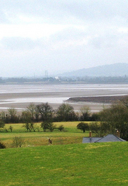
Setting out from Brookend, a few miles north of Bristol on the ‘English bank’, Jane and I found ourselves straight away in a tangle of wide old green lanes. You feel that the landscape must be flat, so close to such a big river, so it comes as a shock to top a rise of ground and find a 20-mile view unrolling. To the east the long South Cotswold ridge, May Hill and the heavy tree cover of the Forest of Dean swelling in the west, and between them the Severn hurrying seaward in a muscular double bend of low-tide tan and silver – we halted to gaze our fill before hurrying down the slope into Purton.
In the early 19th century a 16-mile-long canal was dug from Gloucester down to Sharpness on the lower Severn, cutting out some of the dangerous river bends. Purton, right beside the canal, became a busy little place. Nowadays it’s a sleepy waterside hamlet once more, full of charm and possessed of a true classic of a never-changing pub. No food, no late opening and no nonsense at the Berkeley Arms under the admirable guidance of Mrs Wendy Lord – just a huge fire, stone floors, comfortable old settles, and beer so good it sits up and begs to be drunk. Resistance is useless.
Just down the river path we found an extraordinary elephant’s graveyard of redundant boats – dozens of concrete barges and wooden Severn colliers, rammed into the mud during the late years of the 20th century to stabilise the tide-burrowed bank between river and canal. Lovingly labelled by the ‘Friends of Purton’, they cluster the margins of Severn in death as in life – Orby, Abbey, Huntley and Harriett, their timbers shivered, their sides split, tillers and hawseholes still bravely held aloft, a poignant gathering.
 On down the canal, and through the abutments of a mighty railway bridge that once spanned the Severn. On the night of 25 October 1960, in a thick autumn fog and pitch darkness, two tankers – one loaded with oil, the other with petrol – collided with the bridge piers and exploded, sheeting the river in flame and killing five of the eight crewmen. The damaged bridge was eventually demolished, but the remnants of the tankers are still seen on the riverbed at low tide, and plenty of people around the river port of Sharpness retain vivid memories of that awful night.
Sharpness itself is a rare survival, a working port handling cement, fertiliser and scrap metal far up the tidal Severn. We stopped to watch the cranes swinging bags of fertiliser out of the hold of Shetland Trader, then crossed the canal and made for the field path to Brookend with a sharp appetite apiece. ‘Try the antelope and ginger sauce,’ suggested cheery Dan in the Lammastide Inn. I thought he was pulling my leg, till I looked at the menu board. You’re not in Kansas any more, Toto.
Route map

Due to licensing restrictions in place on Ordnance Survey mapping the mapping extract must be removed prior to printing, or all printing must be limited to 10 paper copies or less and used for personal use only.
Chris’s map annotations:
1 – Lammastide Inn (START)
2 – Lip Lane
3 – Gloucester & Sharpness Canal
4 – Swing Bridge
5 – Berkeley Arms PH
6 – Boat ‘graveyard’
7 – Severn Railway Bridge Abutments
8 – Dockers’ Club
9 – Docks
10 – Swing Bridge
11 – Village Hall
Route profile

Use this GPX file: [FILE:137] for importing the route into digital mapping products, such as Memory Map and Anquet or drop it straight onto your GPS unit. Check the instructions for your particular model to see how this is done.
Use this KML file: [FILE:138] to see the route in Google Maps (under My maps) and Google Earth.
Start & finish
Lammastide PH, Brookend, Sharpness GL13 9SF (OS ref SO 684021).
Getting there
Train to Cam & Dursley (7 miles); several buses to Sharpness.
Road: M5 (Jct 14); A38 (‘Gloucester’); B4066 (‘Sharpness’); right to Brookend. Park at Lammastide PH (please ask permission, and give the pub your custom!)
Walk
6½ miles, easy grade, OS Explorer OL14
From pub, right past phone box; left on bend (‘bridleway’). In 100 yards at gate, keep left on green lane. At T-jct, right (686023 – blue arrow). In 300 yards, opposite gate, left (689022 – ‘footpath’ stone) across fields (gates, yellow arrows/YAs) for 1 mile to Purton. Reach road left of church. (682042). Ahead across canal; left to next bridge (691044); right past Berkeley Arms PH. Riverside path joins canal towpath (687044). NB To see beached boats, detour right here.
Towpath into Sharpness; cross canal (670030). Up steps (‘Severn Way’); ahead past bungalows; right past Dockers’ Club (671029) to road. Left across more seaward of 2 swing bridges (673029). Ahead to road (677026); right (‘Sharpness’). Left beside Village Hall (674021 – fingerpost); cross stile; left to cross stile in hedge (678021); up hedge, through gate at top; YAs to Brookend.
Lunch: Lammastide Inn (friendly and handy), tel: 01453 811337.
Drink: Berkeley Arms (open Wed-Sun,7-10pm; Sat-Sun 12-2pm).
More info:Stroud Tourist Information Centre, tel: 01453 760960.
See books by Christopher Somerville.
More walks: www.christophersomerville.co.uk.
A version of this article first appeared in The Times, 13/03/2010.
Author: Christopher Somerville
 Stanfords’ in-store café is in the running to win the prestigious London Lifestyle Award 2010. Sacred Café, which can be found at the Floral Street entrance of our London store, has been announced as a finalist in the Coffee Shop of the Year category.
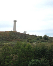
 Truth to tell, Hardy’s Monument looks more like a factory chimney than a memorial to a national hero. But the views over Dorset are sensational. Even more stunning is the prospect from the steep ridge above Waddon House, where we paused on the way back to Portesham. Downs and farmlands, the shingle bar of Chesil Beach, St Catherine’s Chapel on its knoll of strip lynchets, the Devil’s quoits pitch of Portland lying like the Gibraltar of Wessex on a bay of molten silver – if any view could entice an adventurous lad to sea, it would be this.

 If there was ever a fairytale castle… Castle Drogo looks down from a spur of rock, 300 feet to the Teign in the wooded gorge below. Edwardian tea tycoon Julius Drew excavated himself a Norman ancestry, decided to build himself a proper old castle, and got Sir Edwin Luyens to make his dream come true in stark granite. No Mad King Ludwig touches here – all is plain, strong and massive, a triumph of restraint. Marked ways lead from the gorge paths to the castle by way of beautiful gardens of roses and spring flowers. No wonder Drogo is called ‘the last great castle in England’.

 He was signing copies of his new book –
  China and Nepal have resolved a long-running dispute over the height of Mount Everest.
 Our second Walk of the Month from writer and journalist Christopher Somerville, who lives and loves the Bristol area…


 Bladgon Lake Walk