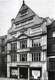
 Established in 1853, Stanfords has since made and supplied maps to royalty, the military, and famous adventurers, explorers, writers, and even dolls, for over 150 years.
Here we’ll be sharing some of the many fascinating stories in our rich history, as we discover more.
Cabinet War Rooms
Stanfords’ maps played an important role in World War II – many of the maps used by Churchill and his administration in the Cabinet War Rooms in London’s Westminster were produced by Edward Stanford Ltd.
To this day, visitors to the museum of the rooms – preserved as they were left on the last day of the war – can see our map of south-east Asia on the wall of the Map Room. And there are many more – the museum curator lists no less than 28 maps published by Stanfords – all to be found in the map chests’ drawers.
Stanfords in miniature

In 1924, as cartographers to the King, Edward Stanford’s was asked to produce a set of tiny maps in a miniature atlas to go in Queen Mary’s dolls’ house. The maps measured approximately 2 x 1.25 inches each and were made precisely to scale, one of which is said to be the smallest map of the world to have been produced.
There are two maps and an atlas currently in Queen Mary’s Dolls’ House which were made by Edward Stanford. The miniature ‘Motoring Map Round Windsor’ shows the counties around London, with the principal roads coloured in red. The ‘Hunt Map’ shows the countryside around Windsor Castle; a black line divides the map diagonally and shows the areas covered by the Old Berkley and Garth Hunts. The tiny Stanford’s Atlas of the British Empire is bound in brown leather with 12 double plates.
You can see Queen Mary’s dolls’ house on display at Windsor Castle.
The National Library of Australia have acquired a copy of the Atlas of the British Empire, reproduced from the original made for Her Majesty Queen Mary’s Doll’s House by Edward Stanford Ltd., cartographers to the King in 1925. You can view the doll’s house Atlas of the British Empire on their online catalogue here.
The Falklands War
Historically we have supplied maps to the military, but in the early 1980s the British Army was unable to procure maps of the Falklands (Malvinas) prior to the UK-Argentine war of 1982, as Argentine diplomats had bought out Stanfords’ entire supply! Officers then had to rely on captured maps, most of which had come from Stanfords.
Read more about the History of Stanfords
Author: Rachel Ricks